
This information is Issued for Puerto Rico and the Virgin Islands.For more information visit your corresponding Seismological Institution or theTsunami Warning Centers
| Event Details | |
|---|---|
| Estimated Maximum Intensity: | II in Juana Díaz, PR |
| Date: |
March 24, 2022 01:45:29 UTC March 23, 2022 21:45:29 Hora Local |
| Region: | Muertos Trough |
| Distances: |
91.25 Km South-Southeast of Mona Island,PR 107.47 Km Southwest of Cabo Rojo,PR 123.56 Km Southwest of Mayagüez,PR |
| Magnitude: | 3.39 Md |
| Location: | Latitude: 17.2841 Longitude: -67.7431 |
| Depth: | 10 Km |
| Tsunami Warning Level: | No Warning, Advisory or Watch is in effect for Puerto Rico and the Virgin Islands |
| Issued Date & Time | 2022-03-23 22:56:10 |
| ID: | 20220324014529 |
Epicentral Map
| BULLETIN 1 Seismic Event/Tsunami |
|
|---|---|
| DATE: | March 23, 2022 |
| LOCAL TIME: | 21:45:29 |
| LATITUDE: | 17.2841 N |
| LONGITUDE: | 67.7431 W |
| LOCATION: |
91.3 Km South-Southeast of Mona Island,PR
123.6 Km Southwest of Mayagüez,PR |
| DEPTH: | 10 Km |
| MAGNITUDE: | 3.39 Md |
| ESTIMATED MAXIMUM INTENSITY: | II in Juana Díaz, PR |
| TSUNAMI ALERT LEVEL: | No Warning, Advisory or Watch is in effect for Puerto Rico and the Virgin Islands |
| DATE & ISSUED TIME | 2022-03-23 22:56:21 |
|
The Puerto Rico Seismic Network (PRSN) received information that this
minor earthquake was reported as
felt in Juana DÃaz with a maximum
intensity of II (Modified Mercalli Scale, MM).
At the moment of generating this bulletin no damages has been reported, but given the size and location this can not be ruled out Based on magnitude, location and historic records the earthquake was not sufficient to generate a destructive tsunami to Puerto Rico and Virgin Islands. |
|

|
|
Technical Information
YEAR MO DA  --ORIGIN--  --LAT N-  --LON W--  DEPTH   RMS   ERH   ERZ  XMAG  FMAG  PMAG  INT
2022-03-24  0145 29.52  17 17.05   67 44.59  10.43  0.28  3.18  4.77        3.39  3.39D
                                                                                         SOURCE
NSTA NPHS  DMIN MODEL GAP ITR NFM NWR NWS NVR REMRKS-AVH  N.XMG-XMMAD-T   N.FMG-FMMAD-T  L F X
  21   21 104.4  PR1  247  11  11  18   7  21     Q  PPR   0.00  0.00      4.00  0.14 D

XMAG2-N.XMG2-XMMAD-T-S  FMAG2-N.FMG2-FMMAD-T-S  PREF.MAG-N.PMAG-PRMAD-T
                         3.39   4.00  0.14 Z        3.39   4.00  0.14 D

REGION= Muertos Trough

STA NET COM CR DIST AZM  AN P/S WT   SEC (TOBS -TCAL -DLY  =RES)  WT   SR  INFO  CAL DUR-W-FMAG-T -AMP-U-PER-W-XMAG-T
CRPR PR HHZ  A104.4  39  55 IPD    45.34 15.82 15.97 0.00 -0.15  1.81     0.361 0.55  87   3.54 Z
CRPR PR HH1  A104.4  39  55 ES  1  57.73 28.21 28.43 0.00 -0.22  0.90S    0.291
MLPR PR HHZ  A106.1  44  55 IPD    45.63 16.11 16.18 0.00 -0.07  1.81     0.296 0.55  62   3.24 Z
MLPR PR HH2  A106.1  44  55 ES  1  57.55 28.03 28.80 0.00 -0.77* 0.88S    0.205
GBPR PR HHZ  A119.4  50  55 EP+ 1  47.49 17.97 17.86 0.00  0.11  0.90     0.064 0.58  64   3.26 Z
GBPR PR HH2  A119.4  50  55 ES  1  61.59 32.07 31.79 0.00  0.28  0.90S    0.158
CELP PR HHZ  A151.4  54  55 EP+ 1  51.67 22.15 21.91 0.00  0.24  0.90     0.066 0.55  80   3.52 Z
CELP PR HH1  A151.4  54  55 ES  1  69.31 39.79 39.00 0.00  0.79* 0.85S    0.130
ECPR PR HHZ  A185.8  51  55 EP+ 1  56.12 26.60 26.28 0.00  0.32  0.90     0.064
ECPR PR HH2  A185.8  51  55 ES  1  76.63 47.11 46.78 0.00  0.33  0.90S    0.153
IGPR PR HHZ  A189.3  66  55 EP+ 1  56.25 26.73 26.72 0.00  0.01  0.90     0.126
IGPR PR HH1  A189.3  66  55 ES  1  76.73 47.21 47.56 0.00 -0.35  0.90S    0.288
GCPR PR HHZ  A209.4  56  55 EP- 1  58.83 29.31 29.26 0.00  0.05  0.90     0.070
GCPR PR HH1  A209.4  56  55 ES  1  79.64 50.12 52.08 0.00 -1.96* 0.00S    0.000
HUMP PR HHZ  A222.3  64  55 EP+ 1  60.35 30.83 30.89 0.00 -0.06  0.90     0.109
HMDR DR BHZ  A240.4 315  55 EP+ 1  62.74 33.22 33.18 0.00  0.04  0.90     0.995
HMDR DR BHE  A240.4 315  55 ES  1  87.04 57.52 59.06 0.00 -1.54* 0.00S    0.000
MTP  PR HHZ  A249.3  68  55 EP+ 1  63.78 34.26 34.30 0.00 -0.04  0.90     0.146
MTP  PR HH1  A249.3  68  55 ES  1  90.32 60.80 61.05 0.00 -0.25  0.90S    0.343
CUPR PR HHZ  A284.5  66  55 EP+ 1  68.22 38.70 38.76 0.00 -0.06  0.90     0.126
CUPR PR HH2  A284.5  66  55 ES  1  96.94 67.42 68.99 0.00 -1.57* 0.00S    0.000
Event Maps
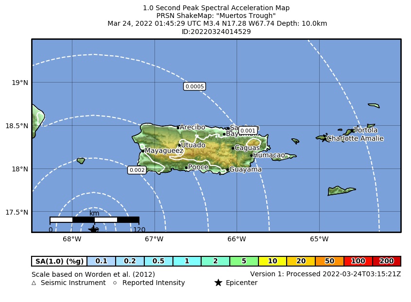 Spectral Acceleration |
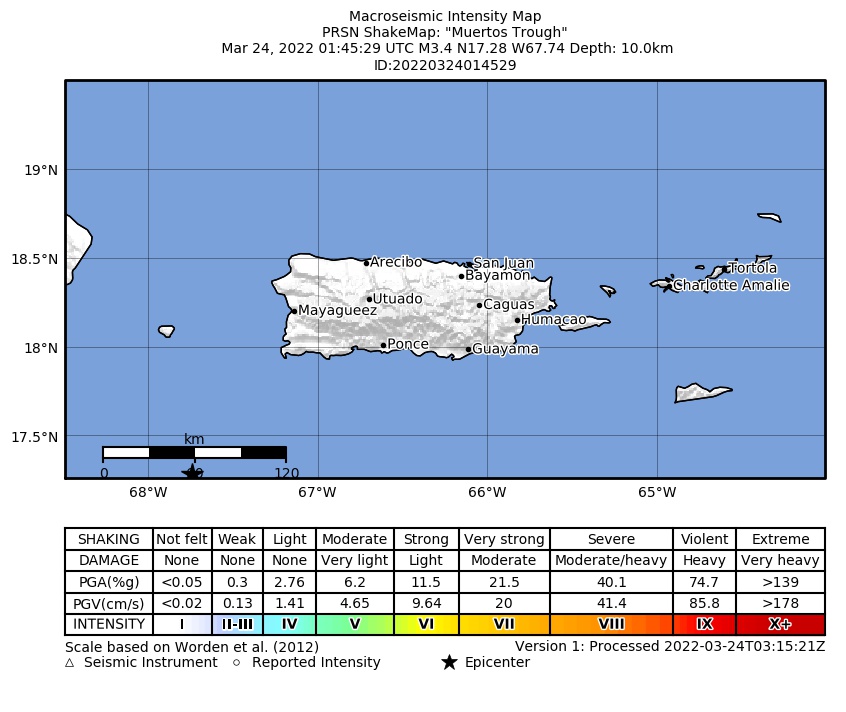 Intensity Map |
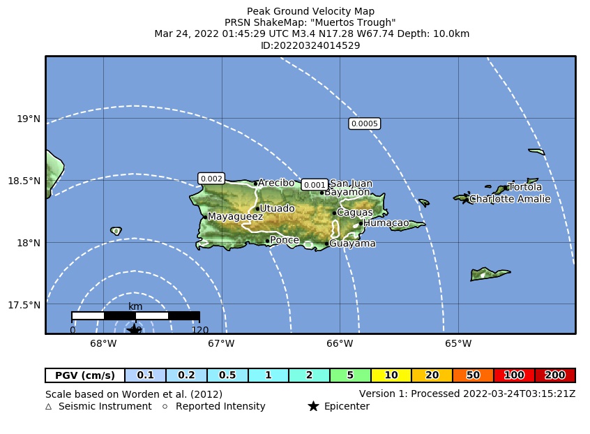 Peak Ground Velocity |
 Peak Ground Acceleration |
 DYFI Map |
Google Map for this Event |