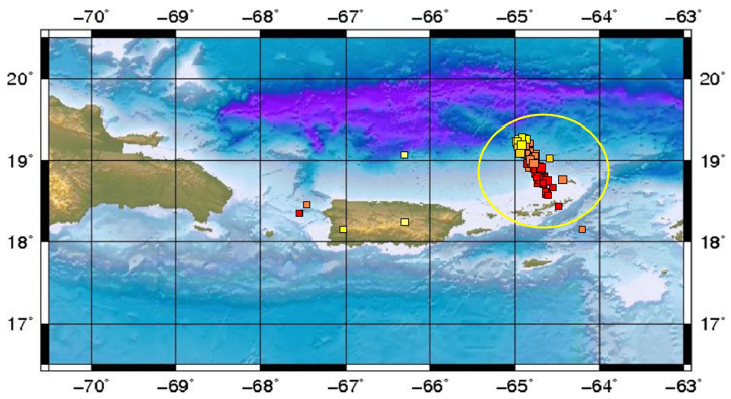
No Warning, Advisory or Watch is in effect for Puerto Rico and the Virgin Islands.

No Warning, Advisory or Watch is in effect for Puerto Rico and the Virgin Islands.
An earthquake is the sudden rapid movement between two rigid blocks of the Earth. This movement occurs along a surface between the two blocks called a fault. This movement releases energy and generates seismic waves that can be recorded by specialized instruments used by scientists. The point on a fault at which the first movement or break occurs during an earthquake is called the earthquake's hypocenter (focus) (Figure 1). In the case of a large earthquake, a section of a fault that is many kilometers long may slip, but there is always a point at which the first movement occurred. This point is reported with a latitude, longitude and depth of the earthquake. The point on the earth's surface, projected directly above the hypocenter is called the epicenter. The epicenter is usually what is reported on the news and ONLY has the latitude and longitude of the event.
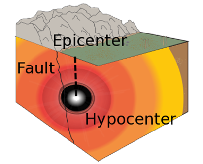
Figure 1. Earthquake hypocenter (focus) and epicenter.
Most commonly, earthquakes are directly or indirectly caused by movements of tectonic plates. Tectonic plates are moved by convection currents which are generated in Earth's mantle. The Earth's mantle is a solid that flows over long time periods in a manner similar to the famous pitch drop experiment that has been running at the University of Queensland since 1972 (Video 1). In the Earth's mantle, the convection currents are generated by changes in temperature and density. The warmer materials in the lower part of the mantle ascend, and the colder ones descend, generating constant changes by the circulation of materials (Figure 2).
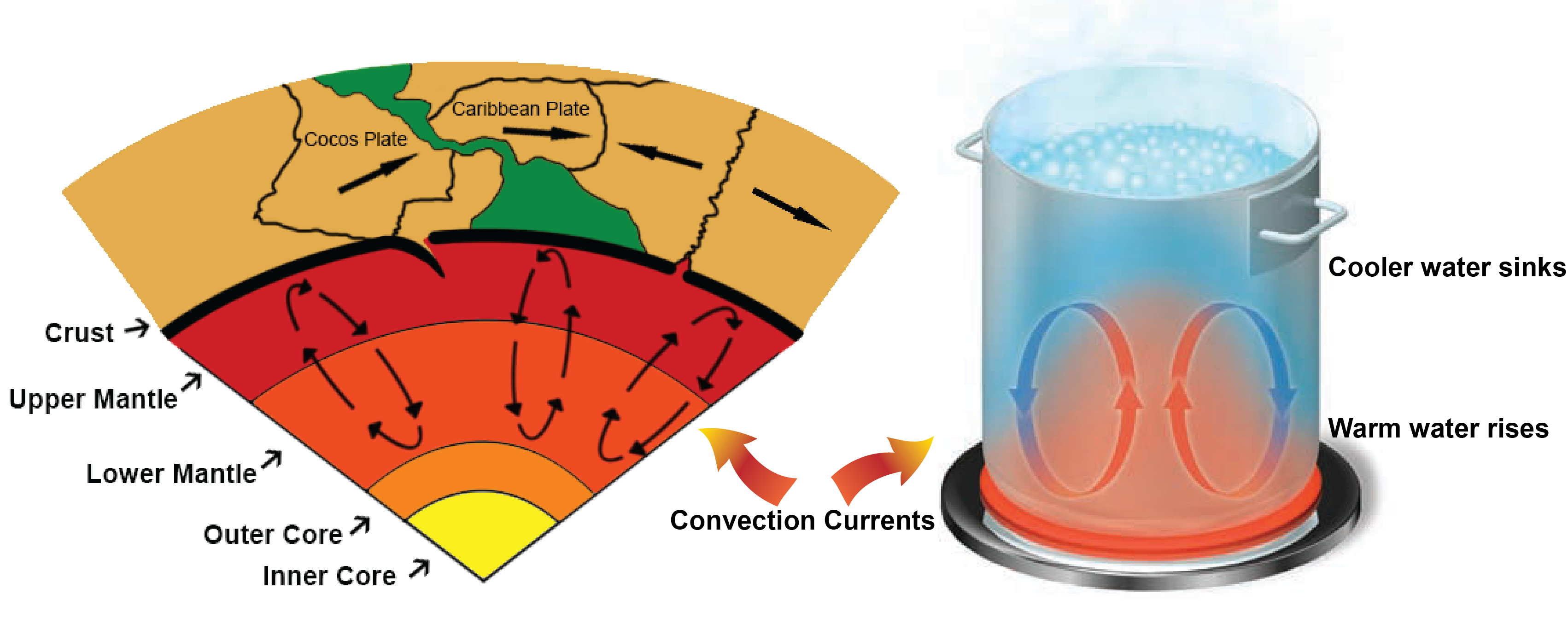
Figure 2. View of the Earth's different layers and convection currents that transform the Earth's crust
Tectonic plates are huge pieces of crust and rigid upper mantle that fit together at their edges and cover the Earth's surface. As illustrated in Figure 3, there are about 12 major plates and several smaller ones. These plates move very slowly-only a few centimeters each year which is similar to the rate at which fingernails grow. Tectonic plates move and shape Earth's surface. They move in different directions and at different rates relative to one another and they interact within their boundaries.
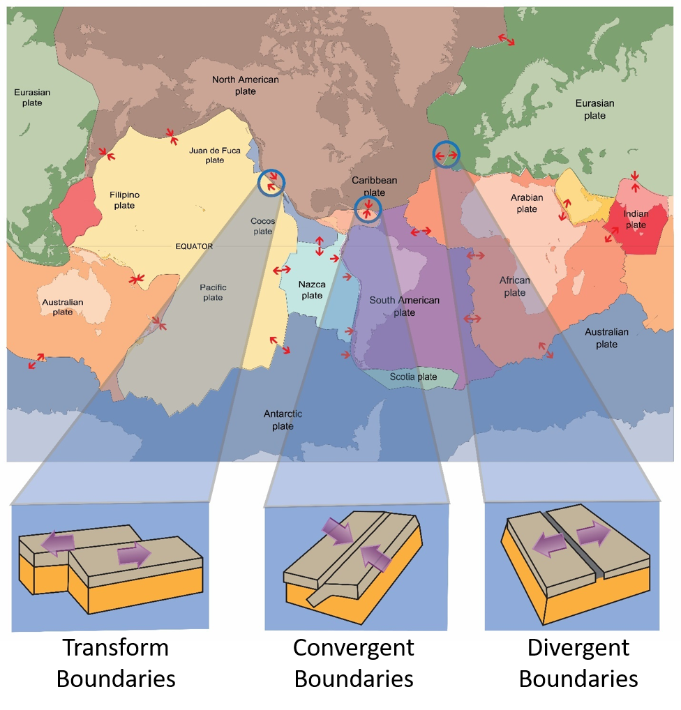
Figure 3. Mosaic of tectonic plates and their relative movement
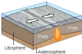
A region where two plates slide horizontally past each other is a transform boundary. Transform boundaries are characterized by long faults, sometimes hundreds of kilometers in length, and by shallow earthquakes. Transform boundaries were named for the way Earth's crust changes, or transforms, its relative direction and velocity from one side of the boundary to the other.
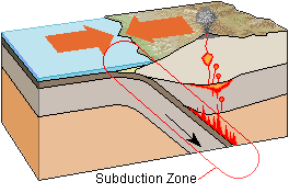
A convergent boundary is when two tectonic plates move toward each other. When two plates collide, the denser plate eventually descends below the other less dense plate and into the mantle (downward convection currents from Figure 2) in a process called subduction.
Regions where two tectonic plates move apart are called divergent boundaries. Most divergent boundaries are found along the seafloor, where they form mid-ocean ridges. The formation of new ocean crust at most divergent boundaries accounts for the high heat flow, volcanism, and earthquakes associated with these boundaries.
The friction between plates can also cause aftershocks, earthquake swarms and sequences.
When an earthquake occurs, it releases the stored-up energy in the form of seismic waves. These travel away from the hypocenter in all directions. These are used to locate and measure the magnitude of an earthquake. The types of seismic waves are:
Named after their capacity to travel across the earth, these are divided into two types—primary (P) waves and secondary (S) waves.
P waves are compressional waves. As P waves travel through matter, the matter alternatively compresses and expands. P waves travel through the earth, as much as sound waves travel through the air. A compressional sort of wave can be illustrated with a Slinky in (Figure 6).
S waves are shear waves, involving a side-to-side motion of molecules. Shear-type waves can also be demonstrated with a Slinky in Figure 6. S waves change the shape of the material that transmits them. Because fluids (gases and liquids) do not resist stresses that cause changes in shape-meaning fluids will not return to their original shape once the stress is removed-they will not transmit S waves.
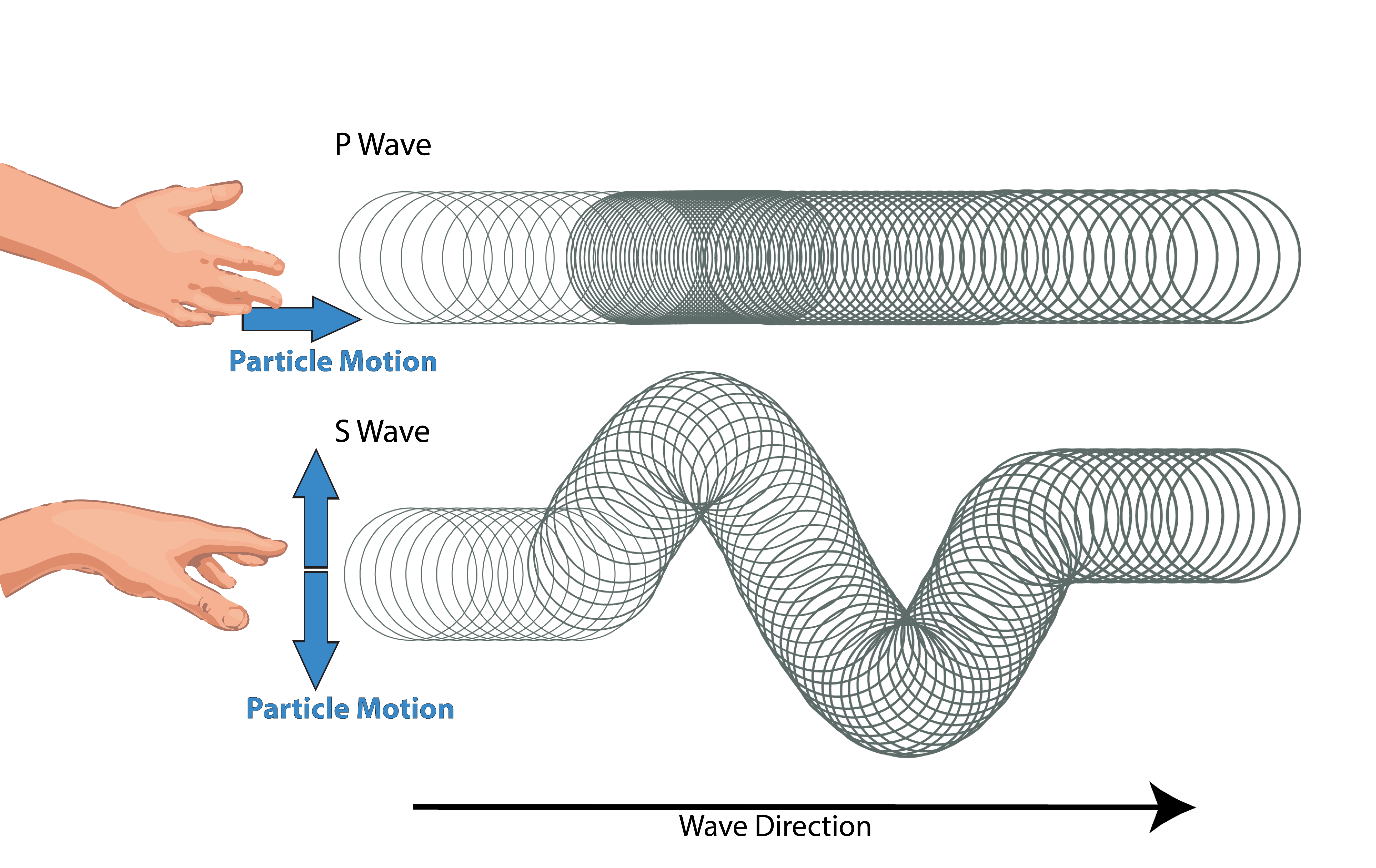
Figure 6. Analogy of Body waves taught using a slinky
Surface waves are named after their restricted movement to the near-earth surface. They are larger in amplitude (amount of ground displacement) than the body waves of an earthquake. Therefore, most of the shaking and resultant structural damage from earthquakes is caused by these waves. Surface waves are divided into two types: Love waves and Rayleigh waves
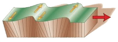
A Love wave is a surface wave with a horizontal motion, transverse (or perpendicular) to the direction the wave is traveling. This wave is one of the last recorded on the seismographs. In our case they are used when more specialized studies of some seismic events are made.
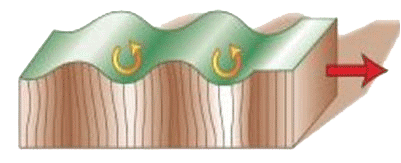
A Rayleigh wave is a seismic surface wave causing the ground to shake in an elliptical motion, with no transverse, or perpendicular motion.
A smaller earthquake that follows the main earthquake within the same region. Aftershocks can continue over a period of weeks, months, or years. In general, the larger the main shock, the larger and more numerous the aftershocks, and the longer they will continue. In the earthquake of October 11, 1918 in Puerto Rico, aftershocks continued for up to six months. The most severe of them occurred on October 24th at 11:43 p.m. and November 12th at 5:45 p.m. A more recent example took place on November 2, 2008, in which an event of magnitude 5.5 (Mw) was recorded in the Trench of Puerto Rico, generating a total of 369 aftershocks.
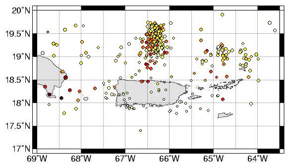
Swarms are many seismic events that occur in the same area with the same characteristics (similar magnitudes) in a given period of time. In our area, for example, twelve swarms were generated in the region of Puerto Rico and the Virgin Islands in 2011. One of these swarms occurred in the Sombrero Seismic Zone and the platform of Virgin Islands, from the 14th to the 15th of July, 2011. For more information please refer to the official report of the Puerto Rico Seismic Network at the following link:http://redsismica.uprm.edu/Spanish/sismos/repanual.php