No Warning, Advisory or Watch is in effect for Puerto Rico and the Virgin Islands.

No Warning, Advisory or Watch is in effect for Puerto Rico and the Virgin Islands.
No. Earthquakes cannot be predicted. Earthquake prediction can be considered the "holy grail" of earthquake science. Despite efforts of many scientists including geologists, physicist, mathematicians, engineers, biologists, amongst others, of today is not possible to predict location, time, or the magnitude (size) of an earthquake in a specific region (e.g. Puerto Rico).
One classic example of an attempt at earthquake prediction occurred in what is dubbed the earthquake capital of the world, Parkfield, CA. Scientists observed that in Parkfield an event with a magnitude greater than 6.0 occurred approximately every 22 years. Based on this observation it was predicted that the next event would occur between 1988 and 1992. Therefore, a dense network of seismographic stations was installed and equipment for geodesic measurements assembled with a series of devices to measure the levels of phreatic mantle electric resistance, magnetic fields and geochemical changes in the zone. The awaited earthquake with a magnitude of 6.0, did not occur until September 28 of 2004 over a decade later than the scientists predicted. Needless to say, this example shows that currently the only thing predictable about earthquakes is that they are unpredictable.
Earthquake forecasting is different from earthquake prediction. Like weather forecasting, earthquake forecasting attempts to provide the probability of a significant earthquake in a specific region over a specific time range, usually on the order of 20 or 50 years. These forecasts are based on multiple datasets including historic seismicity, mapping of faults, and measurements of tectonic plate velocities.
In Puerto Rico, between 1670 and today, 4 significant, destructive
earthquakes have occurred in 1670, 1787, 1867, and 1918. This historical
earthquake record reflects a 51 to 117-year cycle or an average of 83 years
for destructive earthquakes. However, it should be noted that each one of
these events were generated along a different fault, therefore, a calculation
of their re-occurrence rate cannot be based exclusively from these events.
For more comprehensive studies, geologic maps of a particular zone are studied,
giving special attention to active faults and other geologic structures. This
is correlated with intensity distributions of historical earthquakes,
seismic attenuation models, and other statistical data. The result of this
analysis is a map of seismically active zones that identify the regions where
varying degrees of strong earthquakes may occur. The identification of these
high-risk zones is indispensable for deciding the land use and the preparation
of emergency plans.
In Puerto Rico, a study of probabilistic seismic hazard realized in 1987 by
Dr. William McCann calculated a 33 to 50% probability of a strong earthquake
(Intensity VII or more in a Modified Mercalli scale) for different parts of
the island within a 50-year period (Figure 1).
A 2003 research of the Geologic Service of the United States revealed that an area
West-Southwest of Puerto Rico is the most likely location for strong earthquakes
to occur on the island (Figure 1). This probabilistic map does not consider the
secondary effects of earthquakes such as tsunamis, liquefaction, and seismic wave
amplifications that will mostly impact the low coast zones and the highlands that
are capable of generating landslides.
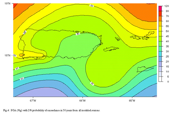
Figure 1