No Warning, Advisory or Watch is in effect for Puerto Rico and the Virgin Islands.

No Warning, Advisory or Watch is in effect for Puerto Rico and the Virgin Islands.
TsunamiReady is a voluntary community recognition program created by the National Weather Service (NWS-NOAA) as an effort to minimize loss of life and property caused by a tsunami and to promote preparedness for tsunami hazards. In Puerto Rico, the Seismic Network (RSPR) manages funds from the National Tsunami Hazard Mitigation Program (NTHMP) and the TsunamiReady Program, in partnership with the NWS forecast office in San Juan, the Federal Emergency Management Agency (FEMA), the Puerto Rico Emergency Management Bureau (PREMB), Municipal Offices for Emergency Management (OMMEs), and communities. Through this program, numerous tools and educational materials are developed, including tsunami flood and evacuation maps, web applications, tsunami evacuation signs, tutorials for seminars and training, pamphlets, brochures, educational materials, media guide, and the Tsunami Curriculum for schools.
By the year 2016, 46 municipalities in Puerto Rico had achieved TsunamiReady recognition from the NWS, with 44 being coastal municipalities and 2 non-coastal ones (Canóvanas and Bayamón). Currently, the RSPR is working diligently to implement the TsunamiReady Supporter program to recognize primarily the private sector, such as resorts, supermarkets, and other facilities located in the evacuation zone. As part of the TsunamiReady Program, and to meet recognition guidelines, we provide 24/7 EMWIN systems, NOAA Radios, and other systems to enhance alert reception capabilities at Tsunami Warning Centers. Technical assistance is also provided in the preparation of response plans and presentations for communities.
This is a summary of the expectations of the TsunamiReady program following the new guidelines from June 1st, 2016. These program guidelines are divided into 3 parts, Mitigation, Preparation and Response:
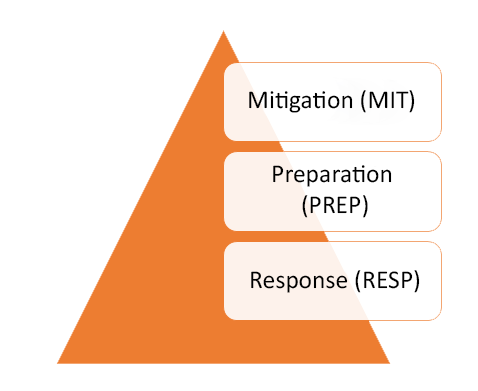
| Mitigation: | Preparation: | Response: |
| MIT-1 Have designated and mapped tsunami hazard zones. | PREP-1 Produce easily understood tsunami evacuation maps as determined to be appropriate by local authorities. | RESP-1 Address tsunami hazards in the community's emergency operations plan (EOP). |
| MIT-2 Include tsunami hazard and community vulnerability information in the community's FEMA-approved multi-hazard mitigation plan. | PREP-2 Support an ongoing sustained tsunami public education effort. This effort should include the development and distribution of outreach materials. | RESP-2 Address tsunami hazards in the emergency operations plans (EOP) for all public schools in the tsunami hazard zone. |
| MIT-3 Install signage, as needed, that identifies for example: | PREP-3 Support an ongoing sustained tsunami education effort specific to public schools in coastal community pursuing TsunamiReady recognition. | RESP-3 Commit to supporting the emergency operations center (EOC) during tsunami incidents if an EOC is opened and activated. |
| (1) tsunami danger area and/or hazard zone (entering and leaving signs), evacuation routes, and assembly area; | PREP-4 Hold at least one community-wide outreach or education activity annually. | RESP-4 Have redundant and reliable means for a 24-hour warning point (and EOC if activated) to receive official tsunami watch, advisory, and warning alerts. |
| (2) provides tsunami response education (go to high ground). | PREP-5 Conduct community exercises that reinforce the concepts contained in PREP-1 through PREP-4. | RESP-5 Have redundant and reliable means for 24-hour warning point and/or EOC to disseminate official tsunami watch, advisory, and warning alerts to the public. |
| PREP-6 Conduct evacuation drills for all public schools in the mapped tsunami evacuation zone to reinforce the concepts contained in PREP-1 through PREP-4. | RESP-6 Have Public Alert-certified NOAA Weather Radio (NWR) receivers in critical facilities and public venues. | |
| RESP-7 Conduct emergency operations plan exercises that test at least one component of the community's EOP or one item from RESP-4 through RESP-6. |