No Warning, Advisory or Watch is in effect for Puerto Rico and the Virgin Islands.

No Warning, Advisory or Watch is in effect for Puerto Rico and the Virgin Islands.
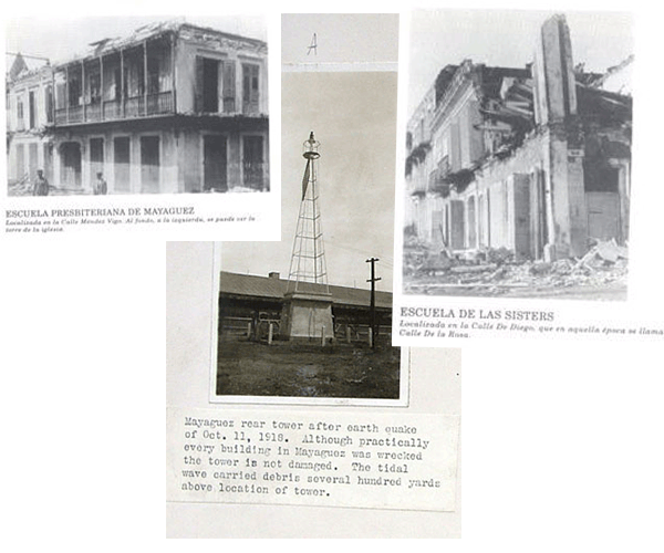
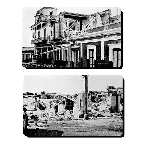
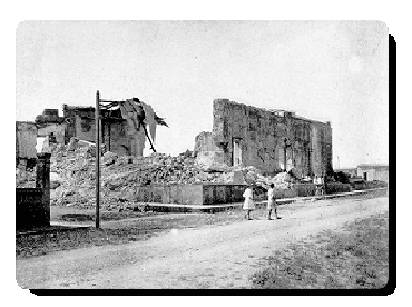
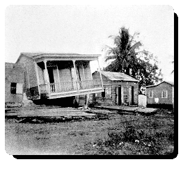
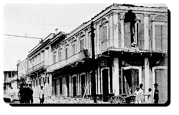
The 11th of October of 1918, the island of Puerto Rico was shaken by one of the most severe earthquakes of its history. The shaking began at 10:14 AM. According to official data, one hundred and sixteen people died, while the economic loss was calculated at four million dollars, two times the annual budget for the whole island at the time. A tsunami which was generated by the earthquake, began affecting the western side of the island within minutes of the strong ground shaking. Wave heights of up to 20 feet were observed and 40 of the deaths from the earthquake were caused by the tsunami itself.
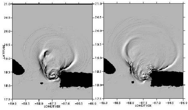
The earthquake originated in the Mona Canyon, 30 miles northwest of Aguadilla, off the northwestern coast of Puerto Rico. Several normal faults have been identified in this submarine canyon. Recent tsunami modeling performed by Mercado and others (1998) at the University of Puerto Rico at Mayagüez suggested that up to four fault segments had to have ruptured to have produced the ensuing tsunami.
The strongest ground shaking was observed in the western and northwestern part of the Island, mostly due to its proximity to the epicenter. At the time of the earthquake the Rossi-Forel intensity scale was in use to determine the intensity of an earthquake, instead of the Modified Mercalli (MM) scale, which is the one presently used in the Western Hemishpere. But, for comparative purposes the corresponding MM Intensity has been determined. The strongest ground shaking occurred in Aguadilla where the intensity was VIII-IX. The ground shaking was also very intense (MM VII-VIII) in surrounding cities of Isabela, Aguada, Añasco and Mayagüez. Nevertheless, the town of Rincón which was closer to the epicenter than the aforementioned towns, suffered less damage, most probably due to the more competent ground conditions. Along the northern coast, the ground shaking was stronger in the east - west direction. In general, the intensity was stronger in the non consolidated alluvial lands that in the corresponding hard rock sites. The difference in intensity was accentuated where the water level was near the surface.
A great number of observers in the areas of heaviest ground shaking reported having seen undulations on the ground surface. In a great number of the cases, these undulations were observed in low lying, water saturated lands.
Fissures were formed on the ground of low level terrain and level areas where subterranean water was close to the surface. These cracks were due to the incoherence of the terrain after being shaken by the passing of the undulations from the earthquake. During large earthquakes, water-saturated sands can liquefy and behave like a dense fluid, rather than a wet solid. Liquefaction can be characterized by cracks or sand boils on the ground surface. During the 1918 earthquake fountain of sands of up to 10 - 12 feet were observed during the earthquake, especially in cane fields in western Puerto Rico.
Despite the steep topography of the island, no significant landslides occurred. Rock falls occurred in areas where the intensity was VI or greater and the ground conditions, were favorable. Most of the rock falls were concentrated in the steep limestone hills near Arecibo and along the limestone cliffs along the shore of northwestern Puerto Rico.
Many bridges were damaged by the earthquake and some were even destroyed.
In those places where the intensity reached or surpassed VI (MM) almost all the brick chimneys of the sugar mills collapsed or were seriously damaged. Those of concrete and steel had very little, if any, damage.
A significant tsunami, ocean waves which can be caused by the displacement of the seafloor during an earthquake, was generated. It reached its greatest elevation in the northwestern corner of the Island (20 feet), where it was observed almost immediately after the earthquake.
In all the places that the wave was observed, people reported that the sea first retreated, exposing in some parts, reefs and the seafloor which had never been seen, even in the lowest of tides. Afterwards, the water returned, reaching equally high elevations. At some localities, the large wave was followed by one or two smaller ones. In the closed bays the water remained disturbed for some time.
Collection of photos of the disaster caused by the 1918 earthquake