No Warning, Advisory or Watch is in effect for Puerto Rico and the Virgin Islands.

No Warning, Advisory or Watch is in effect for Puerto Rico and the Virgin Islands.
In this special report, we present the seismic activity processed by the Puerto Rico Seismic Network of the Geology Department (UPRM Mayagüez) in the local Puerto Rico region (Latitude 17°N-20°N and longitude 63.5°W-69°W), specifically for the Guayama area during 2007 and 2008.
During 2007, the PRSN localized and processed a total of 2,349 earthquakes in the Puerto Rico region. Of these earthquakes, 49 were reported as felt. In the Guayama region (Latitude 18°N-18.3°N and longitude 66.0°W-66.3°W) there was a total of 103 earthquakes localized during that year (Figure 1). Of these earthquakes, 11 were reported as felt in Guayama (Figure 2). Of these 11 earthquakes, 5 had a reported maximum intensity of IV in the Mercalli Modified Scale (MM). The biggest magnitude calculated was 3.0 Fmag (CODA, duration magnitude) for the earthquake that ocurred on April 10th at 03:35. The magnitudes of these microseisms ranged between 2.2 and 3.0 Fmag. The depths ranged between 4.3 to 8.4 km, making these shallow earthquakes.
During 2008, the PRSN localized and processed a total of 684 earthquakes (up to may 15th) in the Puerto Rico region. Of these earthquakes, 21 were reported as felt. In the Guayama region (Latitude 18°N-18.3°N and longitude 66.0°W-66.3°W) there was a total of 26 earthquakes localized during that year (Figure 3). Of these earthquakes, 9 were reported as felt in Guayama (Figure 4). Of these 9 earthquakes, one had a reported maximum intensity of V in the Mercalli Modified Scale (MM) for an earthquake that occurred on May 6th at 21:05. The biggest magnitude calculated was 3.0 Fmag (CODA, duration magnitude) for the earthquake that ocurred on May 15th at 04:48. The magnitudes of these microseisms ranged between 2.1 and 3.0 Fmag. The depths ranged between 5.3 to 17.5 km, making these shallow earthquakes.
Damages asociated to these felt events have not been reported and are not expected due to this seismicity pattern (localization and magnitude). The felt earthquakes in the Guayama area from 2006 to 2008 are listed in table 1 in this report.
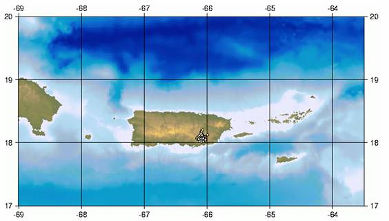
Figure 1: Earthquakes localized in the Puerto Rico region during 2007 in the Guayama area (Latitude 18°N-18.3°N and longitude 66.0°W-66.3°W) (RSPR-UPRM).
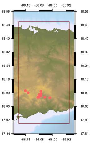
Figure 2: Felt earthquakes in the Guayama area in 2007 (RSPR-UPRM).
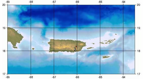
Figure 3: Earthquakes localized in the Puerto Rico region during 2008 in the Guayama area (Latitude 18°N-18.3°N and longitude 66.0°W-66.3°W) (RSPR-UPRM).
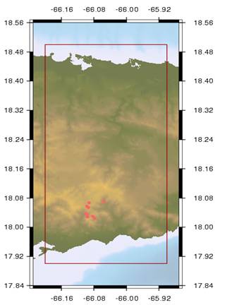
Figure 4: Felt earthquakes in the Guayama area in 2008 (RSPR-UPRM).
Table 1: Felt earthquakes in the Guayama area in the years 2006, 2007 and 2008 (RSPR-UPRM).
| Date | Local Time | Lat. N | Lat. W | Depth. (km) | Magnitude (fmag) | Max Intensity (MM) | Localization |
|
2006/12/06 |
20:38:56 |
18.044 |
66.123 |
6.4 |
2.9 |
III |
7 km N of Guayama |
|
2007/03/07 |
06:11:50 |
18.056 |
66.081 |
7.4 |
3.0 |
IV |
Bo. Carite, Guayama |
|
2007/03/07 |
17:10:49 |
18.089 |
66.069 |
5.9 |
2.3 |
III |
Bo. Carite, Guayama |
|
2007/03/08 |
03:04:38 |
18.074 |
66.068 |
4.7 |
2.4 |
IV |
Bo. Carite, Guayama |
|
2007/03/11 |
04:41:30 |
18.053 |
66.087 |
7.0 |
3.0 |
IV |
Bo. Carite, Guayama |
|
2007/03/11 |
09:14:17 |
18.053 |
66.081 |
7.0 |
2.7 |
III |
9 km NNE of Guayama |
|
2007/03/15 |
10:16:41 |
18.093 |
66.160 |
4.3 |
2.5 |
III |
Bo. Carite, Guayama |
|
2007/04/10 |
03:35:30 |
18.054 |
66.046 |
7.6 |
3.0 |
IV |
Bo. Carite, Guayama |
|
2007/04/10 |
07:26:54 |
18.051 |
66.016 |
8.1 |
2.8 |
IV |
Bo. Carite, Guayama |
|
2007/04/10 |
15:38:03 |
18.081 |
66.144 |
5.5 |
2.2 |
III |
Bo. Carite, Guayama |
|
2007/09/05 |
20:32:14 |
18.070 |
66.078 |
8.4 |
2.8 |
III |
Guayama, P.R |
|
2007/09/16 |
04:17:53 |
18.063 |
66.07 |
7.9 |
2.9 |
II |
39 km S of San Juan |
|
2008/04/15 |
02:34:50 |
18.035 |
66.098 |
6.4 |
2.7 |
II |
6 km NNE of Guayama |
|
2008/05/05 |
16:14:40 |
18.028 |
66.096 |
5.3 |
2.1 |
III |
6 km NNE of Guayama |
|
2008/05/05 |
16:45:36 |
18.037 |
66.099 |
6.6 |
2.4 |
III |
6 km NNE of Guayama |
|
2008/05/06 |
21:05:51 |
18.054 |
66.094 |
8.0 |
2.7 |
V |
8 km NNE of Guayama |
|
2008/05/06 |
22:29:05 |
18.030 |
66.083 |
8.1 |
2.7 |
III |
6 km NNE of Guayama |
|
2008/05/14 |
18:04:54 |
18.025 |
66.079 |
17.5 |
2.3 |
III |
6 km NE of Guayama, PR |
|
2008/05/14 |
20:47:53 |
18.057 |
66.097 |
7.2 |
2.8 |
II |
9 km North of Guayama |
|
2008/05/15 |
04:48:18 |
18.067 |
66.092 |
5.6 |
3.0 |
IV |
9.09 SE of Cayey |
|
2008/05/15 |
05:28:56 |
18.071 |
66.055 |
5.9 |
2.3 |
II |
12 km NNE of Guayama, P.R. |
The area around the Carite neighborhood is localized inside the Patillas Quadrangle as defined by the United States Geological Survey (USGS). Until this moment, there isn't a geological map available for this Quadrangle. The inspection realized by geologists from the PRSN and DRNA found that most of the volcanic sandstone and siltstone altered. There was evidence of hydrothermal alteration as well as deep saprolithic terrain with very little stability. Plutonic rocks were also observed. In the short trip we took around the area, we did not find the presence of faults or terrain cracks that could be associated with the registered earthquakes. However, these observations are preliminary and due to the intensity of the fractured rocks (Figure 1) it should not be discarded. A satelite image obtained of the area through Google Earth shows some valleys in the NE and SW area (Figure 2)
*Taken from the Special Field Report of Carite in Guayama, PR during 2007.
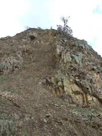
Figure 5. Volcanic rock basset in the 9.2 Kilometer of the State Road Num. 179 in Guayama. Notice the great number of rockfalls.
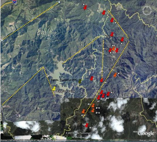
Figure 6. Google Earth Satellite image of Carite Lake and the epicenter of some of the earthquakes analysed by PRSN personnel in 2007.
Special Report prepared (in Spanish) by: Gisela Báez-Sánchez Geologist Analysis and Data Processing Department Coordinator Field Report (in Spanish) prepared by: David N. Cuevas Miranda, M.S. Geologist and Data Analyst Graduate Student May 15th, 2008