
This information is Issued for Puerto Rico and the Virgin Islands.For more information visit your corresponding Seismological Institution or theTsunami Warning Centers
| Event Details | |
|---|---|
| Estimated Maximum Intensity: | V in Guánica, PR |
| Date: |
May 20, 2022 09:40:10 UTC May 20, 2022 05:40:10 Hora Local |
| Region: | Southern Puerto Rico |
| Distances: |
9.29 Km South-Southeast of Guánica,PR 18 Km South-Southeast of Guayanilla,PR 33.07 Km West-Southeast of Ponce,PR |
| Magnitude: | 3.66 Md |
| Location: | Latitude: 17.9153 Longitude: -66.8736 |
| Depth: | 13 Km |
| Tsunami Warning Level: | No Warning, Advisory or Watch is in effect for Puerto Rico and the Virgin Islands |
| Issued Date & Time | 2022-05-20 06:10:06 |
| ID: | 20220520094011 |
Epicentral Map
| BULLETIN 2 Seismic Event/Tsunami |
|
|---|---|
| DATE: | May 20, 2022 |
| LOCAL TIME: | 05:40:10 |
| LATITUDE: | 17.9153 N |
| LONGITUDE: | 66.8736 W |
| LOCATION: |
9.3 Km South-Southeast of Guánica,PR
33.1 Km West-Southeast of Ponce,PR |
| DEPTH: | 13 Km |
| MAGNITUDE: | 3.66 Md |
| ESTIMATED MAXIMUM INTENSITY: | V in Guánica, PR |
| TSUNAMI ALERT LEVEL: | No Warning, Advisory or Watch is in effect for Puerto Rico and the Virgin Islands |
| DATE & ISSUED TIME | 2022-05-20 06:10:12 |
|
The Puerto Rico Seismic Network (PRSN) received information that this
minor earthquake was reported as
felt in the Central region of Puerto Rico and the Southern region of Puerto Rico with a maximum
intensity of V (Modified Mercalli Scale, MM).
At the moment of generating this bulletin no damages has been reported, but given the size and location this can not be ruled out Based on magnitude, location and historic records the earthquake was not sufficient to generate a destructive tsunami to Puerto Rico and Virgin Islands. |
|

|
|
Technical Information
YEAR MO DA  --ORIGIN--  --LAT N-  --LON W--  DEPTH   RMS   ERH   ERZ  XMAG  FMAG  PMAG  INT
2022-05-20  0940 10.94  17 54.92   66 52.42  13.22  0.15  0.57  0.38        3.66  3.66D V
                                                                                         SOURCE
NSTA NPHS  DMIN MODEL GAP ITR NFM NWR NWS NVR REMRKS-AVH  N.XMG-XMMAD-T   N.FMG-FMMAD-T  L F X
  46   46   6.6  PR1  195  14  23  31  13  46     Q  PPX   0.00  0.00     12.00  0.10 D

XMAG2-N.XMG2-XMMAD-T-S  FMAG2-N.FMG2-FMMAD-T-S  PREF.MAG-N.PMAG-PRMAD-T
                         3.66  12.00  0.10 Z        3.66  12.00  0.10 D

REGION= South of Puerto Rico

STA NET COM CR DIST AZM  AN P/S WT   SEC (TOBS -TCAL -DLY  =RES)  WT   SR  INFO  CAL DUR-W-FMAG-T -AMP-U-PER-W-XMAG-T
GBPR PR HHZ  A  6.6 355 149 IPD    13.68  2.74  2.63 0.00  0.11  1.50     0.199
GBPR PR HH1  A  6.6 355 149 ES  1  15.83  4.89  4.68 0.00  0.21  0.75S    0.153
PR05 GS HHZ  A 14.6   5 124 IPU    14.58  3.64  3.48 0.00  0.16  1.50     0.141
PR05 GS HH1  A 14.6   5 124 ES  1  17.83  6.89  6.19 0.00  0.70* 0.00S    0.000
PR03 GS HHZ  A 18.1 338 117 IPU    14.88  3.94  3.94 0.00  0.00  1.50     0.113
PR03 GS HH2  A 18.1 338 117 ES  1  18.08  7.14  7.01 0.00  0.13  0.75S    0.137
MLPR PR HHZ  A 19.0 289 116 IPU    14.96  4.02  4.07 0.00 -0.05  1.50     0.210
MLPR PR HH2  A 19.0 289 116 ES  1  18.12  7.18  7.24 0.00 -0.06  0.75S    0.083
PR06 GS HHZ  A 22.1  45 111 EP+ 1  15.22  4.28  4.51 0.00 -0.23  0.75     0.034
PR06 GS HH1  A 22.1  45 111 ES  1  18.90  7.96  8.03 0.00 -0.07  0.75S    0.140
PR04 GS HHZ  A 22.6  72 111 IPD    15.44  4.50  4.58 0.00 -0.08  1.50     0.214
PR04 GS HH1  A 22.6  72 111 ES  1  19.00  8.06  8.15 0.00 -0.09  0.75S    0.121
PR01 GS HHZ  A 24.4 303 109 IPU    15.64  4.70  4.84 0.00 -0.14  1.50     0.140
PR01 GS HH1  A 24.4 303 109 ES  1  19.17  8.23  8.62 0.00 -0.39  0.75S    0.075
CRPR PR HHZ  A 26.9 292 106 IPU    16.01  5.07  5.20 0.00 -0.13  1.50     0.195
CRPR PR HH2  A 26.9 292 106 ES  1  19.94  9.00  9.26 0.00 -0.26  0.75S    0.080
OBIP PR BHZ  A 31.7  63 103 EP- 1  16.63  5.69  5.90 0.00 -0.21  0.75     0.038
OBIP PR BHE  A 31.7  63 103 ES  1  21.35 10.41 10.50 0.00 -0.09  0.75S    0.104
CELP PR HHZ  A 35.8  60  66 IPD    17.41  6.47  6.53 0.00 -0.06  1.50     0.143 0.55 105   3.62 Z
CELP PR HH2  A 35.8  60  66 ES  1  22.20 11.26 11.62 0.00 -0.36  0.75S    0.078
ICMP PR HHZ  A 36.9  94  66 IPU    17.58  6.64  6.68 0.00 -0.04  1.50     0.369 0.55 103   3.61 Z
ICMP PR HH2  A 36.9  94  66 ES  1  23.11 12.17 11.89 0.00  0.28  0.75S    0.143
UUPR PR HHZ  A 40.7  23  66 IPU    18.09  7.15  7.22 0.00 -0.07  1.50     0.136 0.55 110   3.69 Z
UUPR PR HH1  A 40.7  23  66 ES  1  23.48 12.54 12.85 0.00 -0.31  0.75S    0.149
PRSN PR HHZ  A 44.1 320  66 IPU    18.73  7.79  7.69 0.00  0.10  1.50     0.209
PRSN PR HH2  A 44.1 320  66 ES  1  23.83 12.89 13.69 0.00 -0.80* 0.00S    0.000
AOPR PR HHZ  A 49.4  14  66 IPU    19.39  8.45  8.44 0.00  0.01  1.50     0.147 0.55  97   3.58 Z
AOPR PR HH2  A 49.4  14  66 ES  1  25.86 14.92 15.02 0.00 -0.10  0.75S    0.165
AGPR PR HHZ  A 66.1 338  66 IPU    22.06 11.12 10.79 0.00  0.33  1.26     0.130 0.55  85   3.48 Z
AGPR PR HH1  A 66.1 338  66 ES  1  28.54 17.60 19.21 0.00 -1.61* 0.00S    0.000
ECPR PR HHZ  A 70.1  50  66 IPU    22.28 11.34 11.36 0.00 -0.02  1.12     0.069 0.55 123   3.82 Z
ECPR PR HH2  A 70.1  50  66 ES  1  31.60 20.66 20.22 0.00  0.44  0.55S    0.049
EMPR PR HHZ  A 72.1  30  55 IPU    23.30 12.36 11.63 0.00  0.73* 0.00     0.000 0.55  98   3.62 Z
EMPR PR HH2  A 72.1  30  55 ES  1  32.88 21.94 20.70 0.00  1.24* 0.00S    0.000
SJG  IU BHZ  A 79.7  74  55 EP- 1  23.94 13.00 12.59 0.00  0.41  0.35     0.013 0.73 102   3.54 Z
SJG  IU BH2  A 79.7  74  55 ES  1  32.64 21.70 22.41 0.00 -0.71* 0.00S    0.000
IGPR PR HHZ  A 81.4  85  55 EP+ 1  24.35 13.41 12.82 0.00  0.59* 0.04     0.000 0.55 116   3.78 Z
IGPR PR HH1  A 81.4  85  55 ES  1  36.38 25.44 22.82 0.00  2.62* 0.00S    0.000
IDE  PR EHZ  A 81.5 310  55 EP- 1  24.27 13.33 12.83 0.00  0.50  0.23     0.006 0.58 109   3.70 Z
IDE  PR EHE  A 81.5 310  55 ES  1  34.65 23.71 22.84 0.00  0.87* 0.00S    0.000
PCDR PR BHZ  A172.7 293  55 EP- 1  37.89 26.95 24.37 0.00  2.58* 0.00     0.000 0.55 117   3.89 Z
PCDR PR BHN  A172.7 293  55 ES  1  62.24 51.30 43.38 0.00  7.92* 0.00S    0.000
CUPR PR HHZ  A173.9  75  55 EP+ 1  38.35 27.41 24.52 0.00  2.89* 0.00     0.000 0.55 111   3.84 Z
CUPR PR HH2  A173.9  75  55 ES  1  57.92 46.98 43.65 0.00  3.33* 0.00S    0.000
HMDR DR BHZ  A282.1 291  55 EP+ 1  52.34 41.40 38.22 0.00  3.18* 0.00     0.000
HMDR DR BHE  A282.1 291  55 ES  1  84.56 73.62 68.03 0.00  5.59* 0.00S    0.000
Event Maps
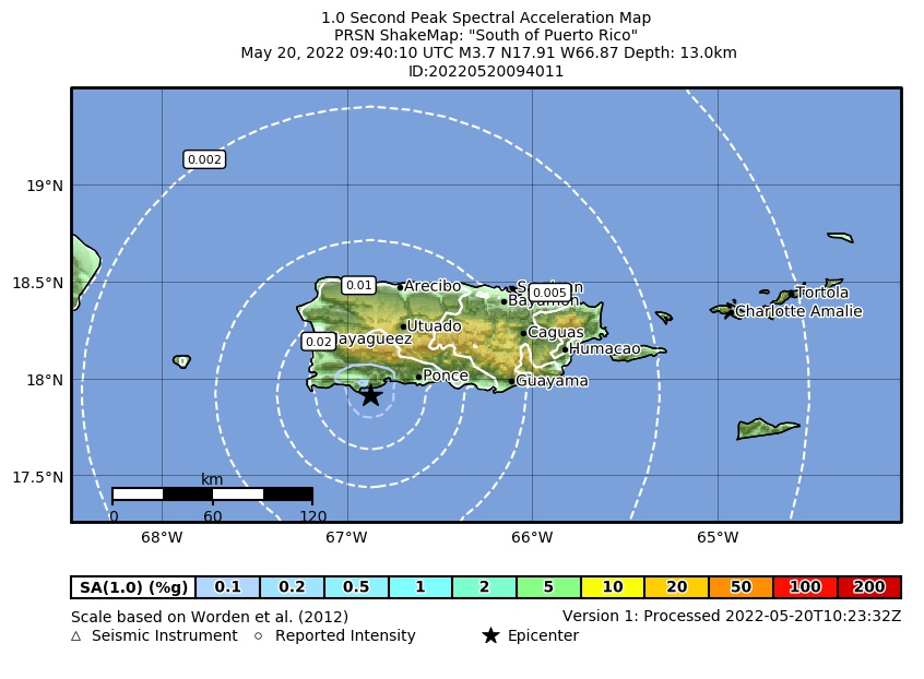 Spectral Acceleration |
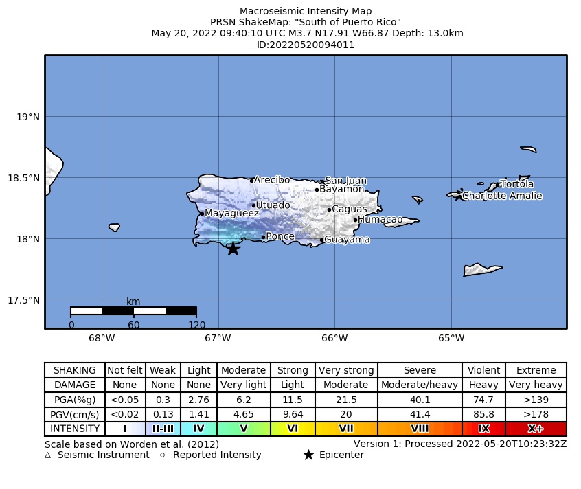 Intensity Map |
 Peak Ground Velocity |
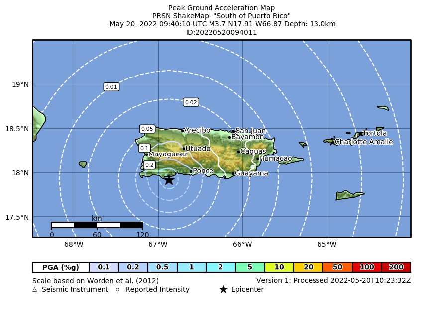 Peak Ground Acceleration |
 DYFI Map |
Google Map for this Event |