
This information is Issued for Puerto Rico and the Virgin Islands.For more information visit your corresponding Seismological Institution or theTsunami Warning Centers
| Event Details | |
|---|---|
| Estimated Maximum Intensity: | IV in Peñuelas, PR |
| Date: |
May 31, 2022 11:44:09 UTC May 31, 2022 07:44:09 Hora Local |
| Region: | South Region of Puerto Rico |
| Distances: |
5.58 Km South-Southeast of Peñuelas,PR 6.54 Km East-Southeast of Guayanilla,PR 14.27 Km West-Southeast of Ponce,PR |
| Magnitude: | 3.28 Md |
| Location: | Latitude: 18.026 Longitude: -66.739 |
| Depth: | 10 Km |
| Tsunami Warning Level: | No Warning, Advisory or Watch is in effect for Puerto Rico and the Virgin Islands |
| Issued Date & Time | 2022-05-31 08:04:18 |
| ID: | 20220531114409 |
Epicentral Map
| BULLETIN 2 Seismic Event/Tsunami |
|
|---|---|
| DATE: | May 31, 2022 |
| LOCAL TIME: | 07:44:09 |
| LATITUDE: | 18.026 N |
| LONGITUDE: | 66.739 W |
| LOCATION: |
5.6 Km South-Southeast of Peñuelas,PR
14.3 Km West-Southeast of Ponce,PR |
| DEPTH: | 10 Km |
| MAGNITUDE: | 3.28 Md |
| ESTIMATED MAXIMUM INTENSITY: | IV in Peñuelas, PR |
| TSUNAMI ALERT LEVEL: | No Warning, Advisory or Watch is in effect for Puerto Rico and the Virgin Islands |
| DATE & ISSUED TIME | 2022-05-31 08:04:26 |
|
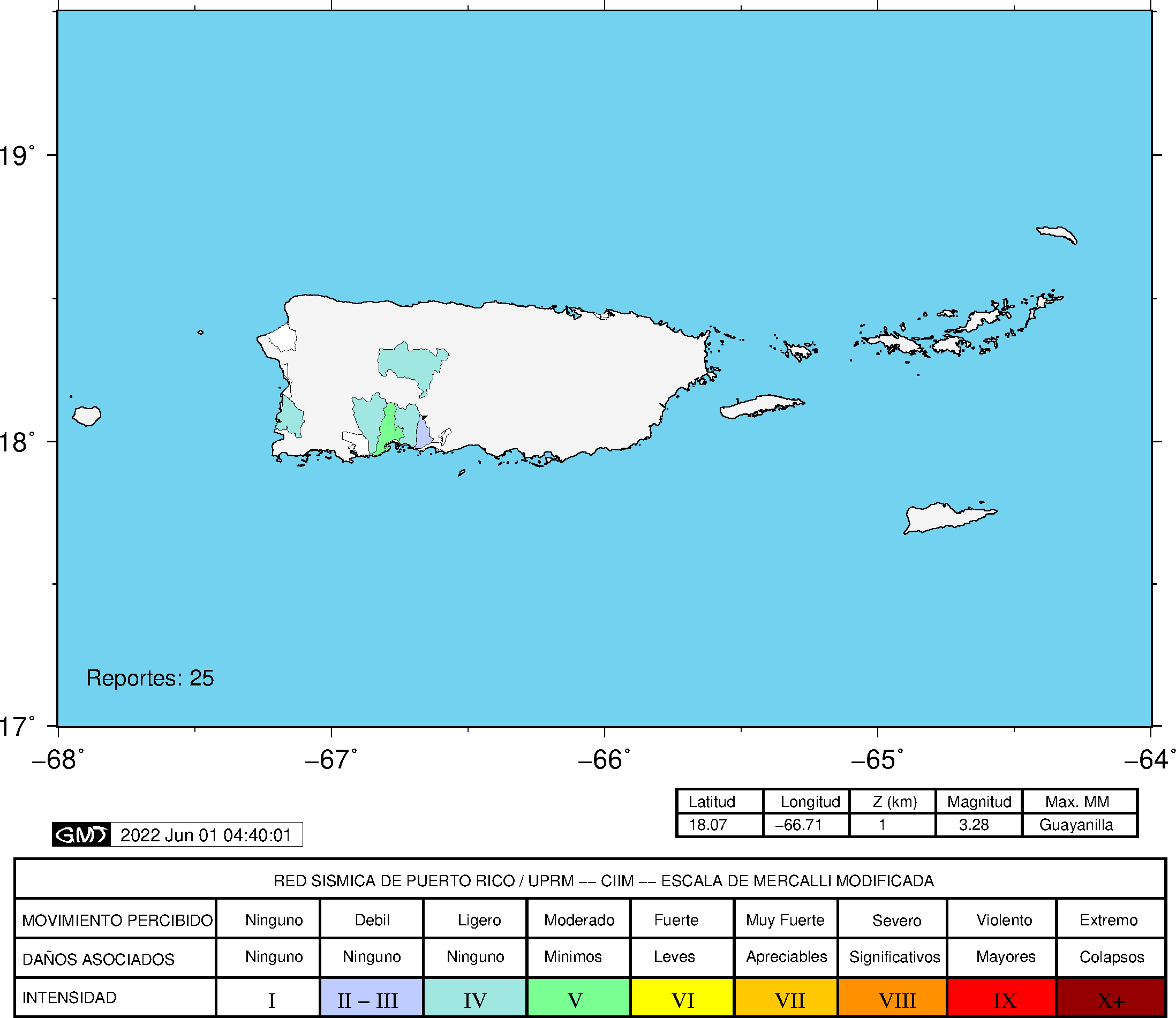
The Puerto Rico Seismic Network (PRSN) received information that this
minor earthquake was reported as
felt in the Southern region of Puerto Rico with a maximum
intensity of IV (Modified Mercalli Scale, MM).
At the moment of generating this bulletin no damages has been reported, but given the size and location this can not be ruled out Based on magnitude, location and historic records the earthquake was not sufficient to generate a destructive tsunami to Puerto Rico and Virgin Islands. |
|

|
|
Technical Information
YEAR MO DA  --ORIGIN--  --LAT N-  --LON W--  DEPTH   RMS   ERH   ERZ  XMAG  FMAG  PMAG  INT
2022-05-31  1144  9.07  18  1.56   66 44.34  10.12  0.23  0.34  0.59        3.28  3.28D IV
                                                                                         SOURCE
NSTA NPHS  DMIN MODEL GAP ITR NFM NWR NWS NVR REMRKS-AVH  N.XMG-XMMAD-T   N.FMG-FMMAD-T  L F X
  45   45   3.6  PR1  121  13  23  36  16  45     Q  PPM   0.00  0.00      9.00  0.11 D

XMAG2-N.XMG2-XMMAD-T-S  FMAG2-N.FMG2-FMMAD-T-S  PREF.MAG-N.PMAG-PRMAD-T
                         3.28   9.00  0.11 Z        3.28   9.00  0.11 D

REGION= Southern Puerto Rico

STA NET COM CR DIST AZM  AN P/S WT   SEC (TOBS -TCAL -DLY  =RES)  WT   SR  INFO  CAL DUR-W-FMAG-T -AMP-U-PER-W-XMAG-T
PR02 GS HHZ  A  3.6 247 156 IPD    11.09  2.02  1.99 0.00  0.03  1.88     0.222
PR02 GS HH1  A  3.6 247 156 ES  1  12.74  3.67  3.54 0.00  0.13  0.94S    0.198
PR06 GS HHZ  A  3.6  24 156 EP+ 1  10.98  1.91  2.00 0.00 -0.09  0.94     0.065
PR06 GS HH1  A  3.6  24 156 ES  1  12.36  3.29  3.56 0.00 -0.27  0.94S    0.252
PR04 GS HHZ  A  9.0 126 129 IPU    11.52  2.45  2.50 0.00 -0.05  1.88     0.257
PR04 GS HH1  A  9.0 126 129 ES  1  13.66  4.59  4.45 0.00  0.14  0.94S    0.156
PR05 GS HHZ  A 13.1 281 115 EP- 1  12.05  2.98  3.04 0.00 -0.06  0.94     0.032
PR05 GS HH1  A 13.1 281 115 ES  1  14.65  5.58  5.41 0.00  0.17  0.94S    0.087
OBIP PR BHZ  A 14.2  82 112 EP+ 1  12.16  3.09  3.19 0.00 -0.10  0.94     0.051
OBIP PR BHN  A 14.2  82 112 ES  1  14.01  4.94  5.68 0.00 -0.74* 0.02S    0.000
GBPR PR HHZ  A 15.9 250 108 IPD    12.41  3.34  3.44 0.00 -0.10  1.88     0.192 0.58  67   3.07 Z
GBPR PR HH1  A 15.9 250 108 ES  1  15.39  6.32  6.12 0.00  0.20  0.94S    0.094
CELP PR HHZ  A 17.8  72 105 EP+ 1  12.74  3.67  3.72 0.00 -0.05  0.94     0.050 0.55  63   3.04 Z
CELP PR HH1  A 17.8  72 105 ES  1  15.10  6.03  6.62 0.00 -0.59* 0.74S    0.066
PR03 GS HHZ  A 21.5 283 100 EP+ 1  13.39  4.32  4.28 0.00  0.04  0.94     0.037
PR03 GS HH1  A 21.5 283 100 ES  1  16.99  7.92  7.62 0.00  0.30  0.94S    0.077
UUPR PR HHZ  A 25.2   4  98 IPU    13.91  4.84  4.83 0.00  0.01  1.88     0.178
UUPR PR HH1  A 25.2   4  98 ES  1  17.28  8.21  8.60 0.00 -0.39  0.94S    0.127
ICMP PR HHZ  A 27.3 124  97 EP+ 1  14.38  5.31  5.16 0.00  0.15  0.94     0.095
ICMP PR HH1  A 27.3 124  97 ES  1  18.57  9.50  9.18 0.00  0.32  0.94S    0.181
MLPR PR HHZ  A 32.9 260  95 EP- 1  14.89  5.82  6.02 0.00 -0.20  0.94     0.055 0.55  75   3.29 Z
MLPR PR HH1  A 32.9 260  95 ES  1  19.74 10.67 10.72 0.00 -0.05  0.94S    0.100
PR01 GS HHZ  A 34.8 272  95 EP+ 1  15.33  6.26  6.31 0.00 -0.05  0.94     0.047
PR01 GS HH1  A 34.8 272  95 ES  1  20.16 11.09 11.23 0.00 -0.14  0.94S    0.087
AOPR PR HHZ  A 35.5 358  94 IPU    15.45  6.38  6.42 0.00 -0.04  1.88     0.181 0.55  80   3.37 Z
AOPR PR HH2  A 35.5 358  94 ES  1  19.97 10.90 11.43 0.00 -0.53* 0.93S    0.122
CRPR PR HHZ  A 39.3 267  94 EP- 1  15.90  6.83  7.00 0.00 -0.17  0.94     0.052 0.55  58   3.10 Z
CRPR PR HH1  A 39.3 267  94 ES  1  21.19 12.12 12.46 0.00 -0.34  0.94S    0.094
PRSN PR HHZ  A 47.9 297  93 EP+ 1  17.14  8.07  8.31 0.00 -0.24  0.94     0.040
PRSN PR HH2  A 47.9 297  93 ES  1  24.02 14.95 14.79 0.00  0.16  0.94S    0.085
EMPR PR HHZ  A 54.6  23  92 IPU    18.98  9.91  9.35 0.00  0.56* 1.67     0.153 0.55  69   3.28 Z
EMPR PR HH1  A 54.6  23  92 ES  1  26.11 17.04 16.64 0.00  0.40  0.94S    0.118
AGPR PR HHZ  A 62.7 322  66 EP+ 1  19.68 10.61 10.51 0.00  0.10  0.86     0.067 0.55  67   3.26 Z
AGPR PR HH1  A 62.7 322  66 ES  1  26.47 17.40 18.71 0.00 -1.31* 0.00S    0.000
SJG  IU BHZ  A 63.1  81  66 EP- 1  19.54 10.47 10.56 0.00 -0.09  0.85     0.096
IGPR PR HHZ  A 67.3  95  66 EP- 1  20.12 11.05 11.15 0.00 -0.10  0.77     0.088
IGPR PR HH1  A 67.3  95  66 ES  1  28.42 19.35 19.85 0.00 -0.50  0.77S    0.173
IDE  PR EHZ  A 86.6 298  55 EP+ 1  23.25 14.18 13.75 0.00  0.43  0.26     0.008
IDE  PR EHN  A 86.6 298  55 ES  1  34.54 25.47 24.48 0.00  1.00* 0.00S    0.000
HUMP PR HHZ  A 95.1  82  55 EP+ 1  24.04 14.97 14.82 0.00  0.15  0.08     0.001 0.55  74   3.39 Z
HUMP PR HH1  A 95.1  82  55 ES  1  34.55 25.48 26.38 0.00 -0.90* 0.00S    0.000
MTP  PR HHZ  A125.9  86  55 EP+ 1  28.80 19.73 18.71 0.00  1.02* 0.00     0.000 0.55  89   3.59 Z
MTP  PR HH1  A125.9  86  55 ES  1  43.65 34.58 33.30 0.00  1.28* 0.00S    0.000
CUPR PR HHZ  A157.2  78  55 EP+ 1  33.76 24.69 22.68 0.00  2.01* 0.00     0.000
CUPR PR HH1  A157.2  78  55 ES  1  51.49 42.42 40.37 0.00  2.05* 0.00S    0.000
Event Maps
 Spectral Acceleration |
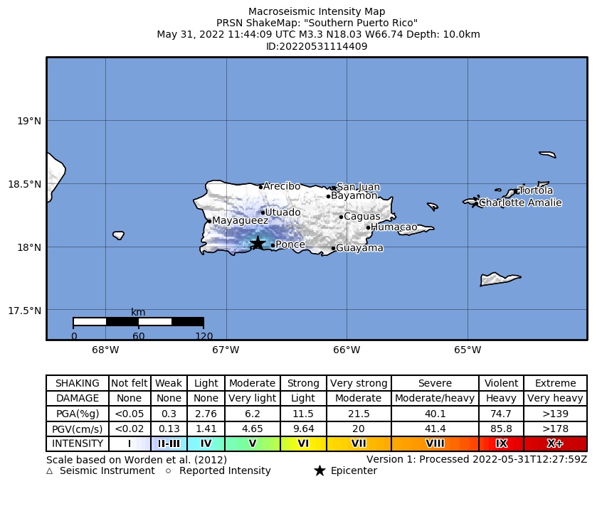 Intensity Map |
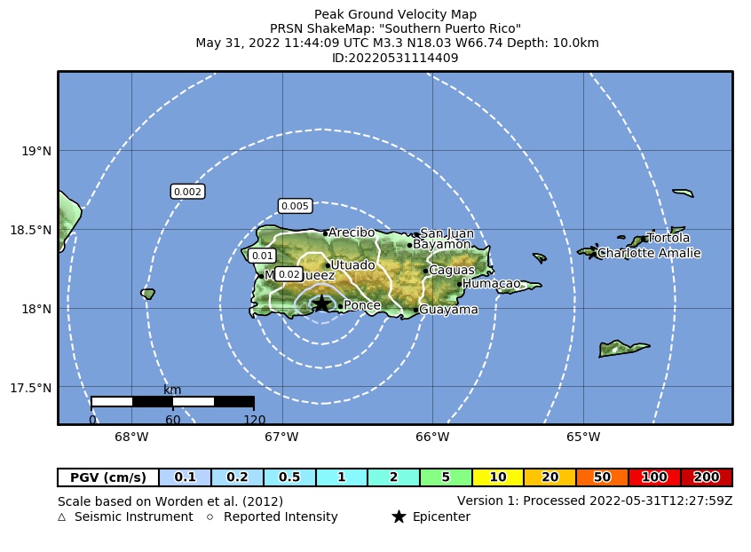 Peak Ground Velocity |
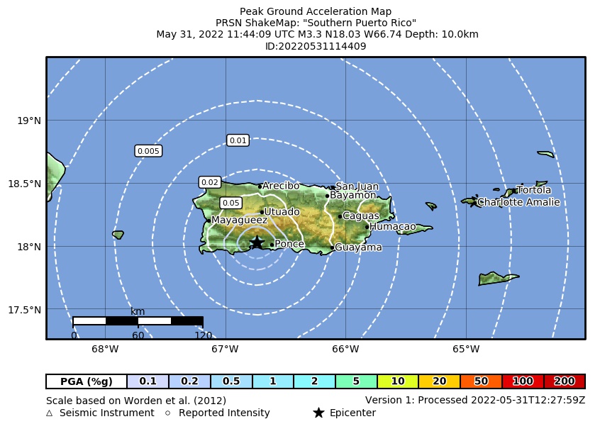 Peak Ground Acceleration |
 DYFI Map |
Google Map for this Event |