
This information is Issued for Puerto Rico and the Virgin Islands.For more information visit your corresponding Seismological Institution or theTsunami Warning Centers
| Event Details | |
|---|---|
| Estimated Maximum Intensity: | III in Lajas, PR |
| Date: |
July 16, 2022 01:32:48 UTC July 15, 2022 21:32:48 Hora Local |
| Region: | South Region of Puerto Rico |
| Distances: |
5.39 Km Southwest of Guánica,PR 12.34 Km East-Southeast of Lajas,PR 32.69 Km South-Southeast of Mayagüez,PR |
| Magnitude: | 3.31 Md |
| Location: | Latitude: 17.9545 Longitude: -66.946 |
| Depth: | 9 Km |
| Tsunami Warning Level: | No Warning, Advisory or Watch is in effect for Puerto Rico and the Virgin Islands |
| Issued Date & Time | 2022-07-15 21:54:09 |
| ID: | 20220716013248 |
Epicentral Map
| BULLETIN 2 Seismic Event/Tsunami |
|
|---|---|
| DATE: | July 15, 2022 |
| LOCAL TIME: | 21:32:48 |
| LATITUDE: | 17.9545 N |
| LONGITUDE: | 66.946 W |
| LOCATION: |
5.4 Km Southwest of Guánica,PR
32.7 Km South-Southeast of Mayagüez,PR |
| DEPTH: | 9 Km |
| MAGNITUDE: | 3.31 Md |
| ESTIMATED MAXIMUM INTENSITY: | III in Lajas, PR |
| TSUNAMI ALERT LEVEL: | No Warning, Advisory or Watch is in effect for Puerto Rico and the Virgin Islands |
| DATE & ISSUED TIME | 2022-07-15 21:54:28 |
|
The Puerto Rico Seismic Network (PRSN) received information that this
minor earthquake was reported as
felt in the Southern region of Puerto Rico with a maximum
intensity of III (Modified Mercalli Scale, MM).
At the moment of generating this bulletin no damages has been reported and are not expected to occur Based on magnitude, location and historic records the earthquake was not sufficient to generate a destructive tsunami to Puerto Rico and Virgin Islands. |
|

|
|
Technical Information
YEAR MO DA  --ORIGIN--  --LAT N-  --LON W--  DEPTH   RMS   ERH   ERZ  XMAG  FMAG  PMAG  INT
2022-07-16  0132 48.55  17 57.27   66 56.76   9.89  0.18  0.36  0.47        3.31  3.31D
                                                                                         SOURCE
NSTA NPHS  DMIN MODEL GAP ITR NFM NWR NWS NVR REMRKS-AVH  N.XMG-XMMAD-T   N.FMG-FMMAD-T  L F X
  48   48   7.4  PR1  181  19  24  36  16  48     Q  PPT   0.00  0.00     21.00  0.16 D

XMAG2-N.XMG2-XMMAD-T-S  FMAG2-N.FMG2-FMMAD-T-S  PREF.MAG-N.PMAG-PRMAD-T
                         3.31  21.00  0.16 Z        3.31  21.00  0.16 D

REGION= Southern Puerto Rico

STA NET COM CR DIST AZM  AN P/S WT   SEC (TOBS -TCAL -DLY  =RES)  WT   SR  INFO  CAL DUR-W-FMAG-T -AMP-U-PER-W-XMAG-T
GBPR PR HHZ  A  7.4  72 134 EP- 1  50.80  2.25  2.30 0.00 -0.05  1.17     0.097
GBPR PR HH2  A  7.4  72 134 ES  1  52.65  4.10  4.09 0.00  0.01  1.17S    0.286
MLPR PR HHZ  A 10.5 280 121 EP+ 1  51.25  2.70  2.67 0.00  0.03  1.17     0.135 0.55  61   2.97 Z
MLPR PR HH1  A 10.5 280 121 ES  1  53.36  4.81  4.75 0.00  0.06  1.17S    0.250
PR03 GS HHZ  A 12.4   4 115 EP+ 1  51.54  2.99  2.93 0.00  0.06  1.17     0.059 0.55  64   3.02 Z
PR03 GS HH1  A 12.4   4 115 ES  1  53.86  5.31  5.22 0.00  0.09  1.17S    0.285
PR05 GS HHZ  A 13.6  41 112 EP- 1  51.70  3.15  3.10 0.00  0.05  1.17     0.043 0.55  42   2.65 Z
PR05 GS HH2  A 13.6  41 112 ES  1  54.80  6.25  5.52 0.00  0.73* 0.00S    0.000
PR01 GS HHZ  A 15.7 305 107 EP+ 1  51.82  3.27  3.40 0.00 -0.13  1.17     0.079
PR01 GS HH1  A 15.7 305 107 ES  1  54.57  6.02  6.05 0.00 -0.03  1.17S    0.157
CRPR PR HHZ  A 18.3 289 103 EP+ 1  52.26  3.71  3.78 0.00 -0.07  1.17     0.114 0.55  57   2.95 Z
CRPR PR HH2  A 18.3 289 103 ES  1  55.12  6.57  6.73 0.00 -0.16  1.17S    0.170
PR02 GS HHZ  A 19.7  70 101 EP- 1  52.55  4.00  4.00 0.00  0.00  1.17     0.051 0.55  83   3.31 Z
PR02 GS HH2  A 19.7  70 101 ES  1  56.08  7.53  7.12 0.00  0.41  1.17S    0.093
PR06 GS HHZ  A 26.0  64  97 EP- 1  53.31  4.76  4.95 0.00 -0.19  1.17     0.046
PR06 GS HH1  A 26.0  64  97 ES  1  57.62  9.07  8.81 0.00  0.26  1.17S    0.091
PR04 GS HHZ  A 29.3  84  95 EP- 1  53.86  5.31  5.46 0.00 -0.15  1.17     0.084 0.55  71   3.22 Z
PR04 GS HH1  A 29.3  84  95 ES  1  59.00 10.45  9.72 0.00  0.73* 0.00S    0.000
PRSN PR HHZ  A 35.9 325  94 EP+ 1  55.11  6.56  6.47 0.00  0.09  1.17     0.066 0.55  61   3.12 Z
PRSN PR HH2  A 35.9 325  94 ES  1  60.91 12.36 11.52 0.00  0.84* 0.00S    0.000
OBIP PR BHZ  A 37.3  74  94 EP- 1  54.97  6.42  6.69 0.00 -0.27  1.17     0.063 0.87  90   3.29 Z
OBIP PR BHN  A 37.3  74  94 ES  1  60.43 11.88 11.91 0.00 -0.03  1.17S    0.089
UUPR PR HHZ  A 40.8  35  93 EP- 1  55.56  7.01  7.22 0.00 -0.21  1.17     0.041 0.55  92   3.53 Z
UUPR PR HH1  A 40.8  35  93 ES  1  60.98 12.43 12.85 0.00 -0.42  1.17S    0.166
CELP PR HHZ  A 41.1  71  93 EP- 1  55.57  7.02  7.26 0.00 -0.24  1.17     0.058 0.55  80   3.40 Z
CELP PR HH1  A 41.1  71  93 ES  1  61.41 12.86 12.92 0.00 -0.06  1.17S    0.087
ICMP PR HHZ  A 45.1  99  93 EP- 1  56.39  7.84  7.88 0.00 -0.04  1.17     0.141 0.55  62   3.17 Z
ICMP PR HH1  A 45.1  99  93 ES  1  62.75 14.20 14.03 0.00  0.17  1.17S    0.198
AOPR PR HHZ  A 47.9  25  92 EP- 1  56.77  8.22  8.32 0.00 -0.10  1.17     0.046 0.55  98   3.59 Z
AOPR PR HH2  A 47.9  25  92 ES  1  63.19 14.64 14.81 0.00 -0.17  1.17S    0.195
AGPR PR HHZ  A 59.4 343  66 EP+ 1  58.75 10.20 10.06 0.00  0.14  1.12     0.113 0.55  71   3.31 Z
AGPR PR HH1  A 59.4 343  66 ES  1  66.60 18.05 17.91 0.00  0.14  1.12S    0.271
EMPR PR HHZ  A 72.7  37  66 EP+ 1  61.15 12.60 11.93 0.00  0.67* 0.06     0.000 0.55  61   3.19 Z
EMPR PR HH2  A 72.7  37  66 ES  1  70.76 22.21 21.24 0.00  0.97* 0.00S    0.000
IDE  PR EHZ  A 72.9 311  66 EP+ 1  60.68 12.13 11.95 0.00  0.18  0.79     0.073 0.58  85   3.47 Z
IDE  PR EHN  A 72.9 311  66 ES  1  70.23 21.68 21.27 0.00  0.41  0.79S    0.137
ECPR PR HHZ  A 73.7  56  66 EP- 1  60.48 11.93 12.07 0.00 -0.14  0.76     0.048 0.55  91   3.55 Z
ECPR PR HH1  A 73.7  56  66 ES  1  69.81 21.26 21.48 0.00 -0.22  0.76S    0.092
SJG  IU BHZ  A 86.1  78  55 EP- 1  62.35 13.80 13.69 0.00  0.11  0.34     0.017 0.73  70   3.20 Z
SJG  IU BH1  A 86.1  78  55 ES  1  73.43 24.88 24.37 0.00  0.51* 0.32S    0.028
IGPR PR HHZ  A 88.9  89  55 EP- 1  62.81 14.26 14.05 0.00  0.21  0.25     0.011 0.55  79   3.44 Z
IGPR PR HH1  A 88.9  89  55 ES  1  74.58 26.03 25.01 0.00  1.02* 0.00S    0.000
GCPR PR HHZ  A 99.3  66  55 EP- 1  64.07 15.52 15.38 0.00  0.14  0.03     0.000 0.55  79   3.45 Z
GCPR PR HH1  A 99.3  66  55 ES  1  76.97 28.42 27.38 0.00  1.04* 0.00S    0.000
HUMP PR HHZ  A118.0  79  55 EP+ 1  66.83 18.28 17.74 0.00  0.54* 0.00     0.000 0.55  82   3.51 Z
HUMP PR HH2  A118.0  79  55 ES  1  81.75 33.20 31.58 0.00  1.62* 0.00S    0.000
MTP  PR HHZ  A148.4  83  55 EP+ 1  71.72 23.17 21.58 0.00  1.59* 0.00     0.000 0.55  96   3.68 Z
MTP  PR HH1  A148.4  83  55 ES  1  90.31 41.76 38.41 0.00  3.35* 0.00S    0.000
Event Maps
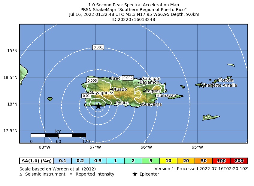 Spectral Acceleration |
 Intensity Map |
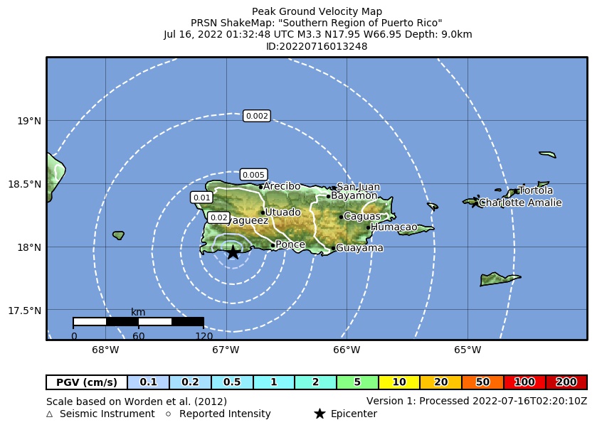 Peak Ground Velocity |
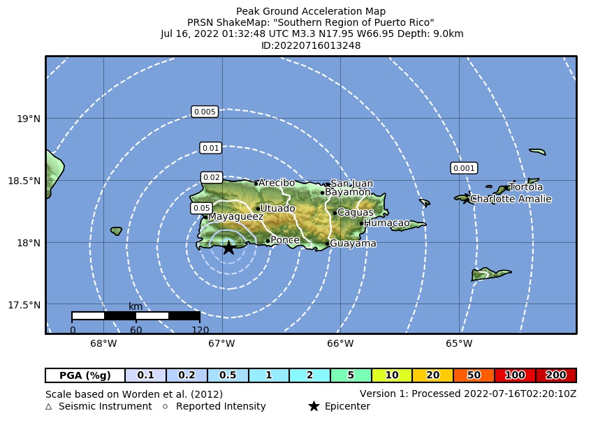 Peak Ground Acceleration |
 DYFI Map |
Google Map for this Event |