
This information is Issued for Puerto Rico and the Virgin Islands.For more information visit your corresponding Seismological Institution or theTsunami Warning Centers
| Event Details | |
|---|---|
| Estimated Maximum Intensity: | V in Guánica, PR |
| Date: |
August 06, 2022 19:53:30 UTC August 06, 2022 15:53:30 Hora Local |
| Region: | Southern Puerto Rico |
| Distances: |
14.28 Km South of Guánica,PR 22.91 Km Southeast of Lajas,PR 38.89 Km Southwest of Ponce,PR |
| Magnitude: | 4.20 Md |
| Location: | Latitude: 17.861 Longitude: -66.9003 |
| Depth: | 12 Km |
| Tsunami Warning Level: | No Warning, Advisory or Watch is in effect for Puerto Rico and the Virgin Islands |
| Issued Date & Time | 2022-08-06 16:31:03 |
| ID: | 20220806195330 |
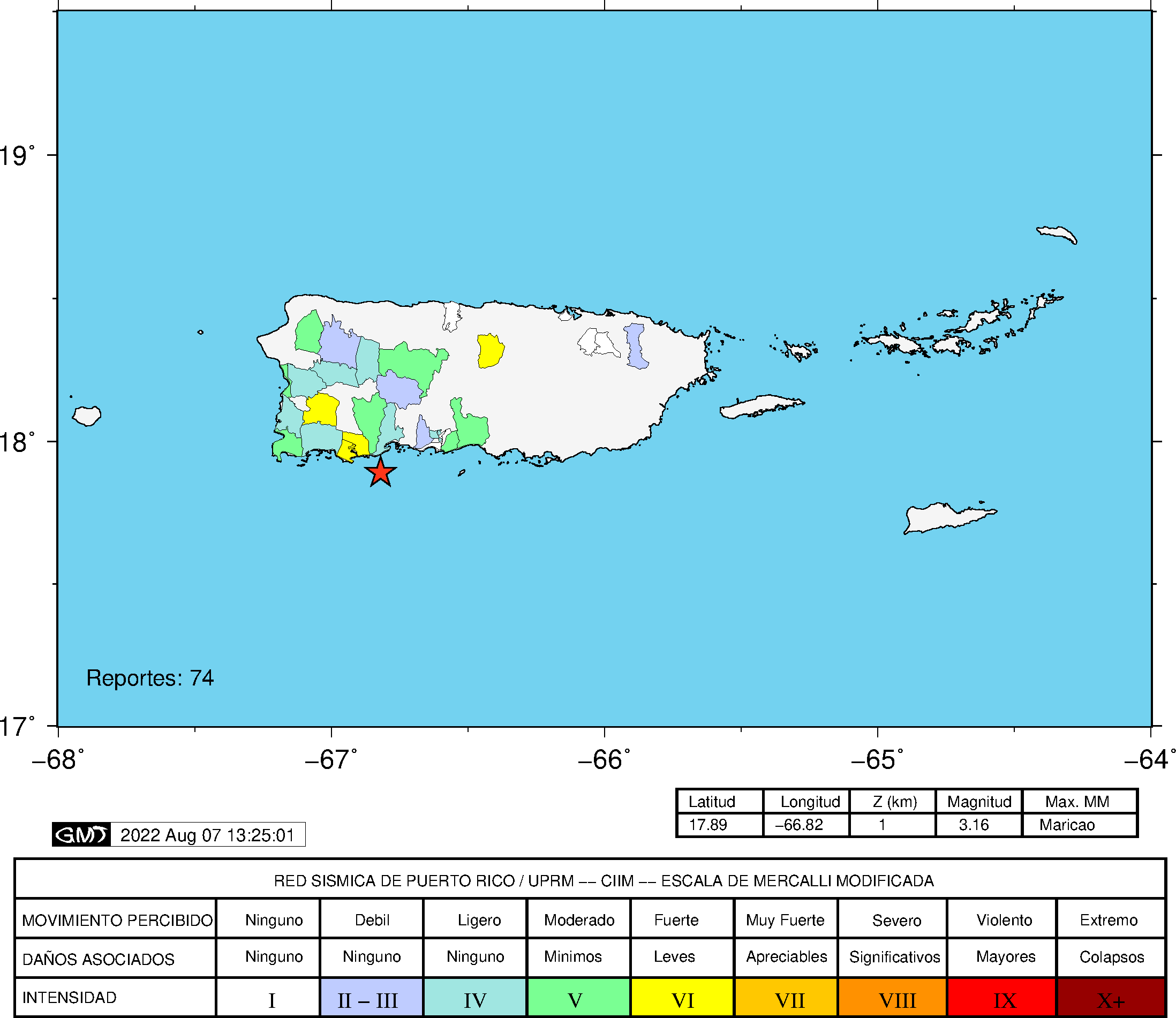
Epicentral Map
| BULLETIN 3 Seismic Event/Tsunami |
|
|---|---|
| DATE: | August 06, 2022 |
| LOCAL TIME: | 15:53:30 |
| LATITUDE: | 17.861 N |
| LONGITUDE: | 66.9003 W |
| LOCATION: |
14.3 Km South of Guánica,PR
38.9 Km Southwest of Ponce,PR |
| DEPTH: | 12 Km |
| MAGNITUDE: | 4.20 Md |
| ESTIMATED MAXIMUM INTENSITY: | V in Guánica, PR |
| TSUNAMI ALERT LEVEL: | No Warning, Advisory or Watch is in effect for Puerto Rico and the Virgin Islands |
| DATE & ISSUED TIME | 2022-08-19 12:51:59 |
|
The Puerto Rico Seismic Network (PRSN) received information that this
light earthquake was reported as
felt in widely throughout Puerto Rico with a maximum
intensity of V (Modified Mercalli Scale, MM).
At the moment of generating this bulletin no damages has been reported, but given the size and location this can not be ruled out Based on magnitude, location and historic records the earthquake was not sufficient to generate a destructive tsunami to Puerto Rico and Virgin Islands. |
|

|
|
Technical Information
YEAR MO DA  --ORIGIN--  --LAT N-  --LON W--  DEPTH   RMS   ERH   ERZ  XMAG  FMAG  PMAG  INT
2022-08-06  1953 30.21  17 51.66   66 54.02  12.93  0.17  0.62  0.39        4.20  4.20D V
                                                                                         SOURCE
NSTA NPHS  DMIN MODEL GAP ITR NFM NWR NWS NVR REMRKS-AVH  N.XMG-XMMAD-T   N.FMG-FMMAD-T  L F X
  57   57  12.8  PR1  221  14  29  30  13  54     Q  PPP   0.00  0.00     15.00  0.11 D

XMAG2-N.XMG2-XMMAD-T-S  FMAG2-N.FMG2-FMMAD-T-S  PREF.MAG-N.PMAG-PRMAD-T
                         4.20  15.00  0.11 Z        4.20  15.00  0.11 D

REGION= South of Puerto Rico

STA NET COM CR DIST AZM  AN P/S WT   SEC (TOBS -TCAL -DLY  =RES)  WT   SR  INFO  CAL DUR-W-FMAG-T -AMP-U-PER-W-XMAG-T
GBPR PR HHZ  A 12.8  10 128 EP- 1  33.38  3.17  3.23 0.00 -0.06  0.87     0.050
GBPR PR HH2  A 12.8  10 128 ES  1  36.10  5.89  5.75 0.00  0.14  0.87S    0.146
MLPR PR HHZ  A 19.4 309 114 EP+ 1  34.35  4.14  4.10 0.00  0.04  0.87     0.080
MLPR PR HH1  A 19.4 309 114 ES  1  37.38  7.17  7.30 0.00 -0.13  0.87S    0.120
PR05 GS HHZ  A 21.0  11 112 IPU    34.56  4.35  4.32 0.00  0.03  1.74     0.117
PR05 GS HH2  A 21.0  11 112 ES  1  38.33  8.12  7.69 0.00  0.43  0.79S    0.126
PR02 GS HHZ  A 21.8  39 111 IPD    34.58  4.37  4.43 0.00 -0.06  1.74     0.146
PR02 GS HH1  A 21.8  39 111 ES  1  38.29  8.08  7.89 0.00  0.19  0.87S    0.133
PR03 GS HHZ  A 23.1 351 109 IPU    34.67  4.46  4.63 0.00 -0.17  1.74     0.119
PR03 GS HH1  A 23.1 351 109 ES  1  38.31  8.10  8.24 0.00 -0.14  0.87S    0.144
PR01 GS HHZ  A 26.2 318 106 EP+ 1  35.15  4.94  5.07 0.00 -0.13  0.87     0.054
PR01 GS HH2  A 26.2 318 106 ES  1  38.54  8.33  9.02 0.00 -0.69* 0.00S    0.000
CRPR PR HHZ  A 27.4 306 105 IPU    35.49  5.28  5.26 0.00  0.02  1.74     0.317
CRPR PR HH2  A 27.4 306 105 ES  1  39.35  9.14  9.36 0.00 -0.22  0.87S    0.119
PR04 GS HHZ  A 27.6  61 105 IPD    35.36  5.15  5.29 0.00 -0.14  1.74     0.220 0.55 178   4.05 Z
PR04 GS HH2  A 27.6  61 105 ES  1  39.76  9.55  9.42 0.00  0.13  0.87S    0.116
OBIP PR BHZ  A 37.1  57 100 EP- 1  36.73  6.52  6.72 0.00 -0.20  0.87     0.042 0.87 187   3.95 Z
OBIP PR BHE  A 37.1  57 100 ES  1  42.04 11.83 11.96 0.00 -0.13  0.87S    0.107
ICMP PR HHZ  A 39.7  85  66 IPD    37.28  7.07  7.09 0.00 -0.02  1.74     0.350 0.55 172   4.09 Z
ICMP PR HH1  A 39.7  85  66 ES  1  43.09 12.88 12.62 0.00  0.26  0.87S    0.124
CELP PR HHZ  A 41.4  55  66 IPD    37.28  7.07  7.34 0.00 -0.27  1.74     0.154 0.55 187   4.17 Z
CELP PR HH2  A 41.4  55  66 ES  1  43.05 12.84 13.07 0.00 -0.23  0.87S    0.133
PRSN PR HHZ  A 47.2 327  66 IPU    38.47  8.26  8.14 0.00  0.12  1.74     0.272
PRSN PR HH2  A 47.2 327  66 ES  1  44.20 13.99 14.49 0.00 -0.50  0.38S    0.045
AOPR PR HHZ  A 55.9  16  66 IPU    39.59  9.38  9.38 0.00  0.00  1.73     0.181 0.55 188   4.19 Z
AOPR PR HH2  A 55.9  16  66 ES  1  46.61 16.40 16.70 0.00 -0.30  0.86S    0.257
AGPR PR HHZ  A 70.7 342  66 IPU    42.02 11.81 11.46 0.00  0.35  1.27     0.127 0.55 185   4.20 Z
AGPR PR HH1  A 70.7 342  66 ES  1  51.22 21.01 20.40 0.00  0.61* 0.00S    0.000
ECPR PR HHZ  A 76.2  48  55 IPD    42.54 12.33 12.18 0.00  0.15  1.00     0.065 0.55 186   4.21 Z
ECPR PR HH1  A 76.2  48  55 ES  1  52.16 21.95 21.68 0.00  0.27  0.50S    0.059
EMPR PR HHZ  A 78.7  29  55 IPD    43.45 13.24 12.49 0.00  0.75* 0.00     0.000 0.55 201   4.28 Z
EMPR PR HH1  A 78.7  29  55 ES  1  53.51 23.30 22.23 0.00  1.07* 0.00S    0.000
IDE  PR EHZ  A 83.4 315  55 IPD    43.87 13.66 13.09 0.00  0.57* 0.01     0.000 0.58 184   4.18 Z
SJG  IU BHZ  A 84.2  70  55 IPD    43.78 13.57 13.19 0.00  0.38  0.59     0.029 0.73 169   4.00 Z
SJG  IU BH1  A 84.2  70  55 ES  1  55.15 24.94 23.48 0.00  1.46* 0.00S    0.000
IGPR PR HHZ  A 84.9  82  55 IPD    43.88 13.67 13.28 0.00  0.39  0.56     0.035 0.55 189   4.23 Z
IGPR PR HH1  A 84.9  82  55 ES  1  55.77 25.56 23.64 0.00  1.92* 0.00S    0.000
GCPR PR HHZ  A 99.7  60  55 IPD    45.90 15.69 15.15 0.00  0.54* 0.01     0.000 0.55 215   4.36 Z
GCPR PR HH1  A 99.7  60  55 ES  1  57.72 27.51 26.97 0.00  0.54* 0.00S    0.000
HUMP PR HHZ  A115.6  74  55 IPD    48.24 18.03 17.17 0.00  0.86* 0.00     0.000 0.55 206   4.34 Z
HUMP PR HH1  A115.6  74  55 ES  1  63.46 33.25 30.56 0.00  2.69* 0.00S    0.000
MTP  PR HHZ  A145.1  79  55 IPD    52.94 22.73 20.91 0.00  1.82* 0.00     0.000 0.55 196   4.33 Z
MTP  PR HH2  A145.1  79  55 ES  1  70.48 40.27 37.22 0.00  3.05* 0.00S    0.000
CUPR PR HHZ  A178.3  73  55 EP+ 1  57.63 27.42 25.10 0.00  2.32* 0.00     0.000
CUPR PR HH1  A178.3  73  55 ES  1  78.57 48.36 44.68 0.00  3.68* 0.00S    0.000
SADR DR BHZ  A202.4 281  55 EP+ 1  60.79 30.58 28.15 0.00  2.43* 0.00     0.000
SADR DR BHN  A202.4 281  55 ES  1  84.50 54.29 50.11 0.00  4.18* 0.00S    0.000
HIDR DR BHZ  A208.3 294  55 EP+ 1  62.06 31.85 28.90 0.00  2.95* 0.00     0.000
STVI PR HHZ  A212.8  74  55 EP+ 2  63.44 33.23 29.48 0.00  3.75* 0.00     0.000 0.55 176   4.31 Z
HMDR DR BHZ  A281.7 292  55 EP+ 1  71.62 41.41 38.19 0.00  3.22* 0.00     0.000
HMDR DR BHN  A281.7 292  55 ES  1 102.15 71.94 67.98 0.00  3.96* 0.00S    0.000
SMDR PR BHZ  A288.7 304  55 EP- 2  74.91 44.70 39.08 0.00  5.62* 0.00     0.000
SDD  DR BHZ  A326.2 283  55 EP+ 2  77.85 47.64 43.82 0.00  3.82* 0.00     0.000
SDD  DR BHN  A326.2 283  55 ES  1 112.75 82.54 78.00 0.00  4.54* 0.00S    0.000
   3 UNWEIGHTED STATIONS NOT PRINTED.
Event Maps
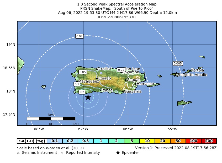 Spectral Acceleration |
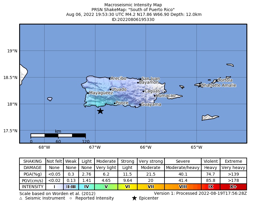 Intensity Map |
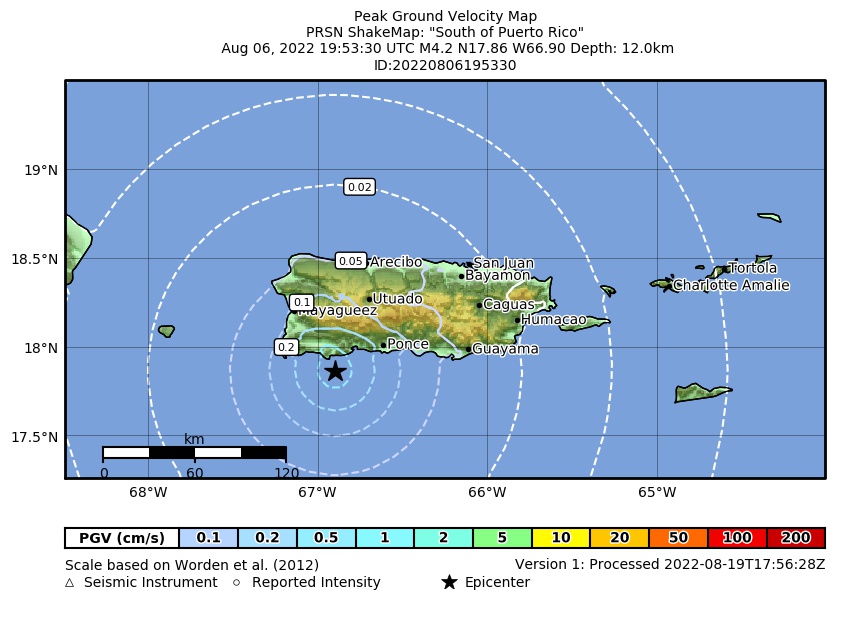 Peak Ground Velocity |
 Peak Ground Acceleration |
 DYFI Map |
Google Map for this Event |