
This information is Issued for Puerto Rico and the Virgin Islands.For more information visit your corresponding Seismological Institution or theTsunami Warning Centers
| Event Details | |
|---|---|
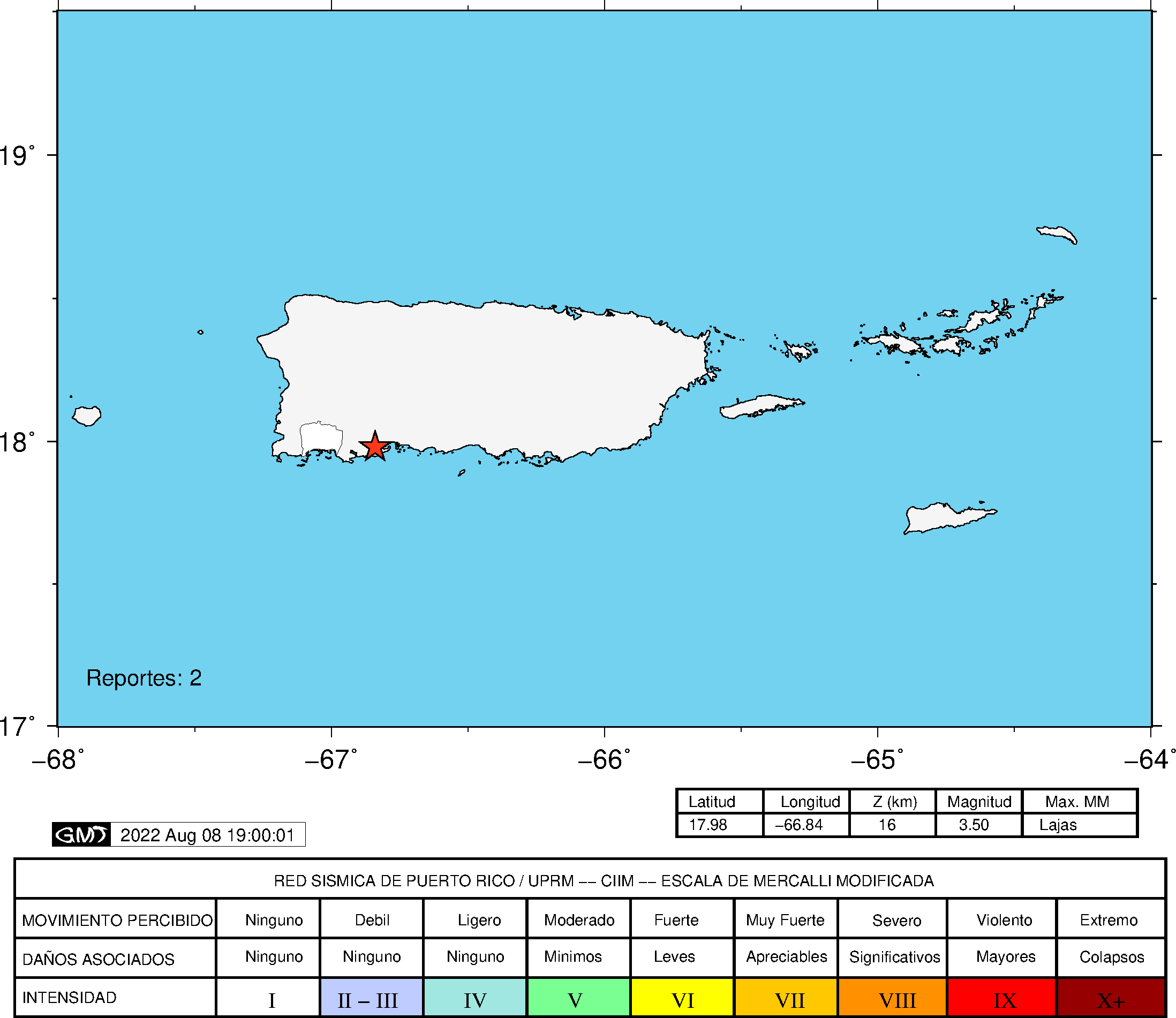
| Estimated Maximum Intensity: | II in San Germán, PR |
| Date: |
August 08, 2022 07:25:35 UTC August 08, 2022 03:25:35 Hora Local |
| Region: | South Region of Puerto Rico |
| Distances: |
8.49 Km East of Guánica,PR 9.97 Km South-Southeast of Guayanilla,PR 26.19 Km West-Southeast of Ponce,PR |
| Magnitude: | 3.50 Md |
| Location: | Latitude: 17.978 Longitude: -66.8363 |
| Depth: | 16 Km |
| Tsunami Warning Level: | No Warning, Advisory or Watch is in effect for Puerto Rico and the Virgin Islands |
| Issued Date & Time | 2022-08-08 04:35:35 |
| ID: | 20220808072535 |
Epicentral Map
| BULLETIN 1 Seismic Event/Tsunami |
|
|---|---|
| DATE: | August 08, 2022 |
| LOCAL TIME: | 03:25:35 |
| LATITUDE: | 17.978 N |
| LONGITUDE: | 66.8363 W |
| LOCATION: |
8.5 Km East of Guánica,PR
26.2 Km West-Southeast of Ponce,PR |
| DEPTH: | 16 Km |
| MAGNITUDE: | 3.50 Md |
| ESTIMATED MAXIMUM INTENSITY: | II in San Germán, PR |
| TSUNAMI ALERT LEVEL: | No Warning, Advisory or Watch is in effect for Puerto Rico and the Virgin Islands |
| DATE & ISSUED TIME | 2022-08-08 04:35:40 |
|
The Puerto Rico Seismic Network (PRSN) received information that this
minor earthquake was reported as
felt in San Germán with a maximum
intensity of II (Modified Mercalli Scale, MM).
At the moment of generating this bulletin no damages has been reported, but given the size and location this can not be ruled out Based on magnitude, location and historic records the earthquake was not sufficient to generate a destructive tsunami to Puerto Rico and Virgin Islands. |
|

|
|
Technical Information
YEAR MO DA  --ORIGIN--  --LAT N-  --LON W--  DEPTH   RMS   ERH   ERZ  XMAG  FMAG  PMAG  INT
2022-08-08  0725 35.68  17 58.68   66 50.18  16.11  0.10  0.34  0.26        3.50  3.50D II
                                                                                         SOURCE
NSTA NPHS  DMIN MODEL GAP ITR NFM NWR NWS NVR REMRKS-AVH  N.XMG-XMMAD-T   N.FMG-FMMAD-T  L F X
  58   58   4.6  PR1  159  17  29  33  16  58     Q  PPW   0.00  0.00     26.00  0.21 D

XMAG2-N.XMG2-XMMAD-T-S  FMAG2-N.FMG2-FMMAD-T-S  PREF.MAG-N.PMAG-PRMAD-T
                         3.50  26.00  0.21 Z        3.50  26.00  0.21 D

REGION= Southern Puerto Rico

STA NET COM CR DIST AZM  AN P/S WT   SEC (TOBS -TCAL -DLY  =RES)  WT   SR  INFO  CAL DUR-W-FMAG-T -AMP-U-PER-W-XMAG-T
GBPR PR HHZ  A  4.6 266 160 IPD    38.63  2.95  2.88 0.00  0.07  1.49     0.161 0.58 109   3.44 Z
GBPR PR HH2  A  4.6 266 160 ES  1  41.03  5.35  5.13 0.00  0.22  0.75S    0.121
PR05 GS HHZ  A  8.0 342 147 IPD    38.82  3.14  3.09 0.00  0.05  1.49     0.123 0.55 131   3.65 Z
PR05 GS HH2  A  8.0 342 147 ES  1  41.47  5.79  5.50 0.00  0.29  0.75S    0.142
PR02 GS HHZ  A  8.0  61 147 IPU    38.71  3.03  3.09 0.00 -0.06  1.49     0.129 0.55  69   3.07 Z
PR02 GS HH2  A  8.0  61 147 ES  1  41.36  5.68  5.50 0.00  0.18  0.75S    0.129
PR03 GS HHZ  A 14.5 313 128 IPU    39.37  3.69  3.71 0.00 -0.02  1.49     0.098 0.55  83   3.27 Z
PR03 GS HH1  A 14.5 313 128 ES  1  42.04  6.36  6.60 0.00 -0.24  0.75S    0.096
PR04 GS HHZ  A 17.6  89 121 IPU    39.67  3.99  4.06 0.00 -0.07  1.49     0.135 0.55  85   3.32 Z
PR04 GS HH2  A 17.6  89 121 ES  1  42.98  7.30  7.23 0.00  0.07  0.75S    0.081
MLPR PR HHZ  A 22.0 268 112 IPD    40.22  4.54  4.62 0.00 -0.08  1.49     0.194 0.55 104   3.53 Z
MLPR PR HH2  A 22.0 268 112 ES  1  43.86  8.18  8.22 0.00 -0.04  0.75S    0.082
PR01 GS HHZ  A 25.3 285 107 IPD    40.74  5.06  5.06 0.00  0.00  1.49     0.141 0.55  92   3.43 Z
PR01 GS HH1  A 25.3 285 107 ES  1  44.62  8.94  9.01 0.00 -0.07  0.75S    0.063
OBIP PR BHZ  A 25.4  73 107 IPD    40.72  5.04  5.07 0.00 -0.03  1.49     0.106 0.87  86   3.17 Z
OBIP PR BHN  A 25.4  73 107 ES  1  44.53  8.85  9.02 0.00 -0.17  0.75S    0.067
CRPR PR HHZ  A 29.1 277 103 IPD    41.18  5.50  5.57 0.00 -0.07  1.49     0.184 0.55 128   3.76 Z
CRPR PR HH2  A 29.1 277 103 ES  1  45.39  9.71  9.91 0.00 -0.20  0.75S    0.075
CELP PR HHZ  A 29.3  68 102 IPD    41.24  5.56  5.60 0.00 -0.04  1.49     0.105 0.55 117   3.68 Z
CELP PR HH2  A 29.3  68 102 ES  1  45.37  9.69  9.97 0.00 -0.28  0.75S    0.068
UUPR PR HHZ  A 32.8  21 100 IPU    41.74  6.06  6.09 0.00 -0.03  1.49     0.149 0.55 133   3.82 Z
UUPR PR HH1  A 32.8  21 100 ES  1  45.81 10.13 10.84 0.00 -0.71* 0.00S    0.000
ICMP PR HHZ  A 34.3 107  99 IPU    41.93  6.25  6.30 0.00 -0.05  1.49     0.261
ICMP PR HH2  A 34.3 107  99 ES  1  47.01 11.33 11.21 0.00  0.12  0.75S    0.114
AOPR PR HHZ  A 41.7  12  96 IPU    43.01  7.33  7.33 0.00  0.00  1.49     0.163 0.55 124   3.80 Z
AOPR PR HH2  A 41.7  12  96 ES  1  48.58 12.90 13.05 0.00 -0.15  0.75S    0.158
PRSN PR HHZ  A 42.0 310  95 IPU    43.14  7.46  7.37 0.00  0.09  1.49     0.136 0.55  85   3.45 Z
PRSN PR HH2  A 42.0 310  95 ES  1  48.86 13.18 13.12 0.00  0.06  0.75S    0.085
AGPR PR HHZ  A 61.5 332  63 IPU    46.17 10.49 10.09 0.00  0.40  0.18     0.003 0.55  91   3.54 Z
AGPR PR HH2  A 61.5 332  63 ES  1  53.68 18.00 17.96 0.00  0.04  0.69S    0.139
ECPR PR HHZ  A 62.7  52  63 IPU    45.97 10.29 10.25 0.00  0.04  1.36     0.193 0.55 140   3.93 Z
ECPR PR HH1  A 62.7  52  63 ES  1  53.18 17.50 18.24 0.00 -0.74* 0.00S    0.000
EMPR PR HHZ  A 64.1  30  63 IPU    46.87 11.19 10.42 0.00  0.77* 0.00     0.000 0.55  75   3.36 Z
EMPR PR HH1  A 64.1  30  63 ES  1  54.02 18.34 18.55 0.00 -0.21  0.66S    0.115
SJG  IU BHZ  A 74.2  78  63 IPU    47.66 11.98 11.70 0.00  0.28  0.95     0.115 0.73  62   3.08 Z
SJG  IU BH2  A 74.2  78  63 ES  1  56.80 21.12 20.83 0.00  0.29  0.47S    0.051
IGPR PR HHZ  A 77.3  90  63 IPU    48.24 12.56 12.09 0.00  0.47  0.00     0.000 0.55  83   3.47 Z
IGPR PR HH1  A 77.3  90  63 ES  1  57.88 22.20 21.52 0.00  0.68* 0.00S    0.000
IDE  PR EHZ  A 80.5 305  63 IPD    49.13 13.45 12.50 0.00  0.95* 0.00     0.000 0.58  55   3.08 Z
IDE  PR EHE  A 80.5 305  63 ES  1  58.32 22.64 22.25 0.00  0.39  0.07S    0.001
GCPR PR HHZ  A 87.7  65  63 IPU    49.52 13.84 13.41 0.00  0.43  0.00     0.000 0.55  93   3.59 Z
GCPR PR HH1  A 87.7  65  63 ES  1  58.85 23.17 23.87 0.00 -0.70* 0.00S    0.000
HUMP PR HHZ  A106.1  79  63 IPD    52.19 16.51 15.74 0.00  0.77* 0.00     0.000 0.55 108   3.74 Z
HUMP PR HH2  A106.1  79  63 ES  1  63.90 28.22 28.02 0.00  0.20  0.00S    0.000
MTP  PR HHZ  A136.6  84  63 IPU    56.90 21.22 19.60 0.00  1.62* 0.00     0.000 0.55  97   3.68 Z
MTP  PR HH1  A136.6  84  63 ES  1  72.43 36.75 34.89 0.00  1.86* 0.00S    0.000
CUPR PR HHZ  A168.4  77  63 EP- 2  62.33 26.65 23.63 0.00  3.02* 0.00     0.000 0.55 132   3.99 Z
CUPR PR HH1  A168.4  77  63 ES  2  80.99 45.31 42.06 0.00  3.25* 0.00S    0.000
PCDR PR BHZ  A173.8 291  63 EP- 2  63.05 27.37 24.31 0.00  3.06* 0.00     0.000
PCDR PR BHN  A173.8 291  63 ES  1  79.11 43.43 43.27 0.00  0.16  0.00S    0.000
STVI PR HHZ  A203.2  77  63 EP+ 2  67.58 31.90 28.03 0.00  3.87* 0.00     0.000 0.55 110   3.87 Z
STVI PR HH2  A203.2  77  63 ES  1  88.67 52.99 49.89 0.00  3.10* 0.00S    0.000
SADR DR BHZ  A207.1 277  63 EP- 2  67.65 31.97 28.53 0.00  3.44* 0.00     0.000
SADR DR BHN  A207.1 277  63 ES  1  87.34 51.66 50.78 0.00  0.88* 0.00S    0.000
HIDR DR BHZ  A210.0 290  63 EP- 2  67.11 31.43 28.89 0.00  2.54* 0.00     0.000 0.00  83   2.76 Z
HIDR DR BHE  A210.0 290  63 ES  1  88.06 52.38 51.42 0.00  0.96* 0.00S    0.000
HMDR DR BHZ  A283.5 289  63 EP+ 1  75.30 39.62 38.20 0.00  1.42* 0.00     0.000 0.00 149   3.38 Z
HMDR DR BHE  A283.5 289  63 ES  1 104.44 68.76 68.00 0.00  0.76* 0.00S    0.000
Event Maps
 Spectral Acceleration |
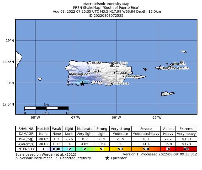 Intensity Map |
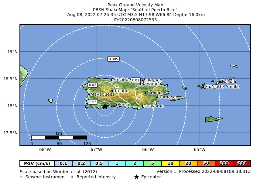 Peak Ground Velocity |
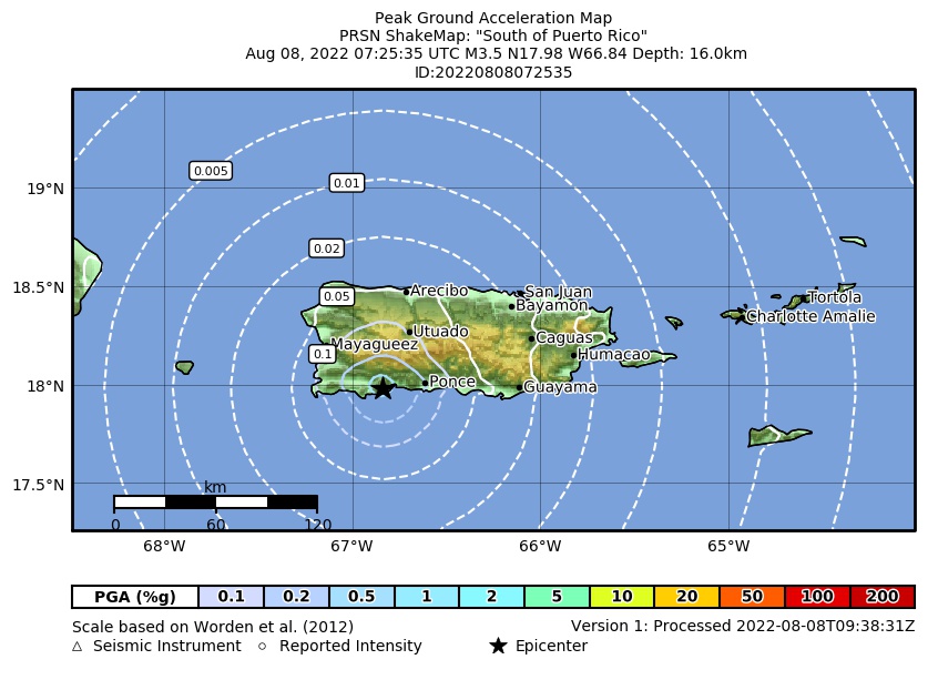 Peak Ground Acceleration |
 DYFI Map |
Google Map for this Event |