
This information is Issued for Puerto Rico and the Virgin Islands.For more information visit your corresponding Seismological Institution or theTsunami Warning Centers
| Event Details | |
|---|---|
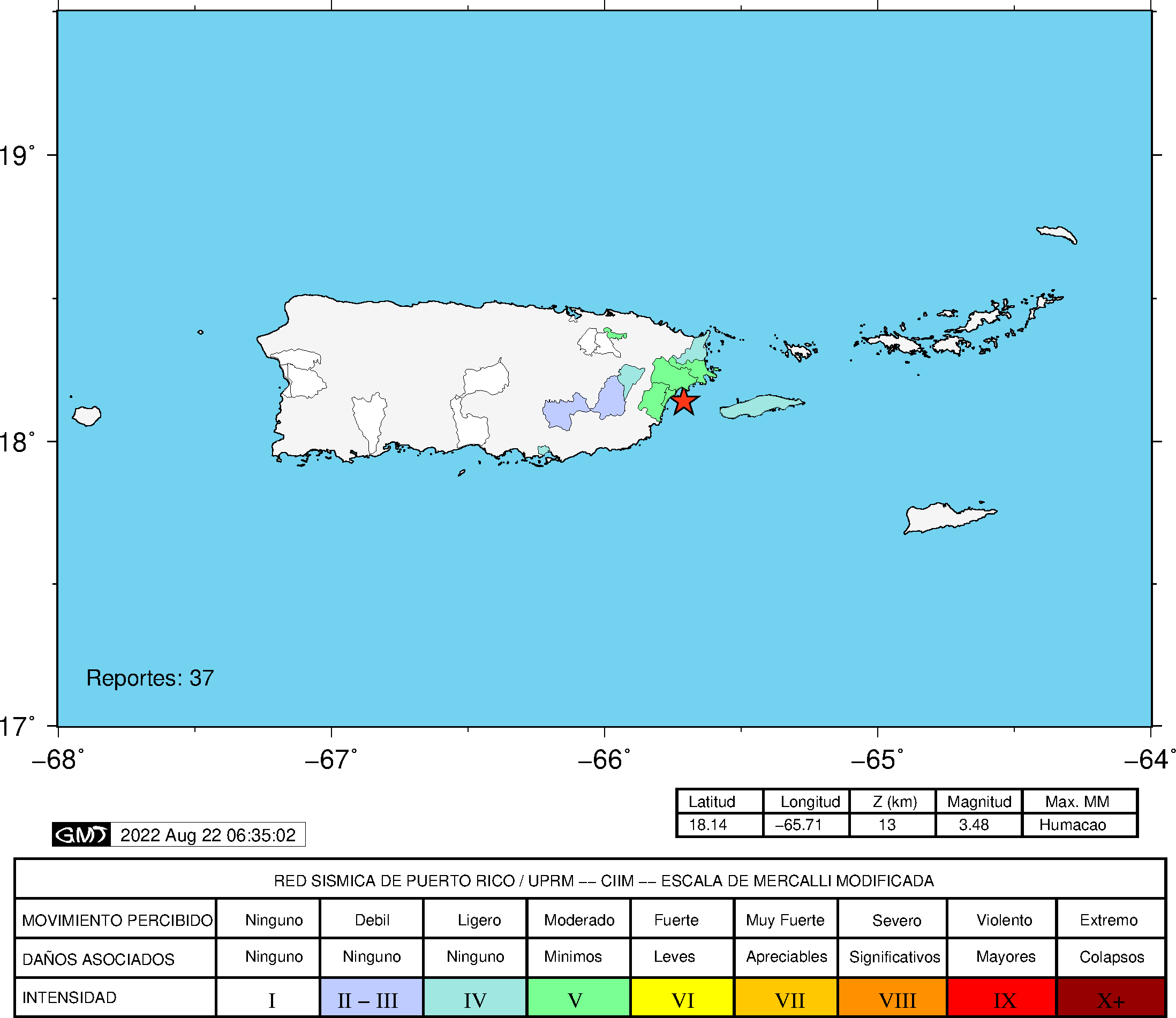
| Estimated Maximum Intensity: | IV in Humacao, PR |
| Date: |
August 21, 2022 07:49:09 UTC August 21, 2022 03:49:09 Hora Local |
| Region: | East Region of Puerto Rico |
| Distances: |
9.86 Km Southeast of Naguabo,PR 11.13 Km South-Southeast of Ceiba,,PR 46.93 Km East-Southeast of San Juan,PR |
| Magnitude: | 3.71 Md |
| Location: | Latitude: 18.1656 Longitude: -65.7015 |
| Depth: | 14 Km |
| Tsunami Warning Level: | No Warning, Advisory or Watch is in effect for Puerto Rico and the Virgin Islands |
| Issued Date & Time | 2022-08-21 03:53:04 |
| ID: | 20220821074908 |
Epicentral Map
| BULLETIN 1 Seismic Event/Tsunami |
|
|---|---|
| DATE: | August 21, 2022 |
| LOCAL TIME: | 03:49:09 |
| LATITUDE: | 18.1656 N |
| LONGITUDE: | 65.7015 W |
| LOCATION: |
9.9 Km Southeast of Naguabo,PR
46.9 Km East-Southeast of San Juan,PR |
| DEPTH: | 14 Km |
| MAGNITUDE: | 3.71 Md |
| ESTIMATED MAXIMUM INTENSITY: | IV in Humacao, PR |
| TSUNAMI ALERT LEVEL: | No Warning, Advisory or Watch is in effect for Puerto Rico and the Virgin Islands |
| DATE & ISSUED TIME | 2022-08-21 04:31:32 |
|
The Puerto Rico Seismic Network (PRSN) received information that this
minor earthquake was reported as
felt in the Eastern region of Puerto Rico with a maximum
intensity of IV (Modified Mercalli Scale, MM).
At the moment of generating this bulletin no damages has been reported, but given the size and location this can not be ruled out Based on magnitude, location and historic records the earthquake was not sufficient to generate a destructive tsunami to Puerto Rico and Virgin Islands. |
|

|
|
Technical Information
YEAR MO DA  --ORIGIN--  --LAT N-  --LON W--  DEPTH   RMS   ERH   ERZ  XMAG  FMAG  PMAG  INT
2022-08-21  0749  9.49  18  9.94   65 42.09  14.98  0.24  0.91  0.94        3.71  3.71D  IV
                                                                                         SOURCE
NSTA NPHS  DMIN MODEL GAP ITR NFM NWR NWS NVR REMRKS-AVH  N.XMG-XMMAD-T   N.FMG-FMMAD-T  L F X
  56   56  15.8  PR1  138  13  28  19  10  56     Q  PP0   0.00  0.00     20.00  0.13 D

XMAG2-N.XMG2-XMMAD-T-S  FMAG2-N.FMG2-FMMAD-T-S  PREF.MAG-N.PMAG-PRMAD-T
                         3.71  20.00  0.13 Z        3.71  20.00  0.13 D

REGION= Eastern Puerto Rico

STA NET COM CR DIST AZM  AN P/S WT   SEC (TOBS -TCAL -DLY  =RES)  WT   SR  INFO  CAL DUR-W-FMAG-T -AMP-U-PER-W-XMAG-T
HUMP PR HHZ  A 15.8 261 120 EP+ 1  13.47  3.98  3.77 0.00  0.21  1.19     0.135 0.55  75   3.19 Z
HUMP PR HH1  A 15.8 261 120 ES  1  16.56  7.07  6.71 0.00  0.36  1.19S    0.387
MTP  PR HHZ  A 17.5 115 116 EP- 1  13.58  4.09  3.97 0.00  0.12  1.19     0.196 0.55  72   3.16 Z
MTP  PR HH1  A 17.5 115 116 ES  1  16.57  7.08  7.07 0.00  0.01  1.19S    0.456
GCPR PR HHZ  A 43.4 292  92 EP- 1  17.03  7.54  7.56 0.00 -0.02  1.19     0.145 0.55  90   3.51 Z
GCPR PR HH2  A 43.4 292  92 ES  1  22.69 13.20 13.46 0.00 -0.26  1.19S    0.391
CUPR PR HHZ  A 47.0  70  92 EP+ 1  17.46  7.97  8.06 0.00 -0.09  1.19     0.176 0.55  94   3.55 Z
CUPR PR HH1  A 47.0  70  92 ES  1  23.40 13.91 14.35 0.00 -0.44  1.19S    0.370
SJG  IU BHZ  A 47.8 263  92 IPU    17.68  8.19  8.18 0.00  0.01  2.38     0.285 0.73  98   3.47 Z
SJG  IU BH1  A 47.8 263  92 ES  1  23.78 14.29 14.56 0.00 -0.27  1.19S    0.133
IGPR PR HHZ  A 48.3 243  92 EP- 1  17.72  8.23  8.24 0.00 -0.01  1.19     0.145 0.55 102   3.63 Z
IGPR PR HH1  A 48.3 243  92 ES  1  23.67 14.18 14.67 0.00 -0.49  1.19S    0.345
ECPR PR HHZ  A 72.0 284  63 EP+ 1  21.24 11.75 11.49 0.00  0.26  0.94     0.102 0.55 133   3.90 Z
ECPR PR HH1  A 72.0 284  63 ES  1  30.24 20.75 20.45 0.00  0.30  0.94S    0.235
STVI PR HHZ  A 81.5  75  63 IPU    22.55 13.06 12.69 0.00  0.37  1.30     0.292 0.55 109   3.72 Z
STVI PR HH2  A 81.5  75  63 ES  1  31.95 22.46 22.59 0.00 -0.13  0.65S    0.157
ICMP PR HHZ  A 92.7 251  63 EP- 1  24.59 15.10 14.11 0.00  0.99* 0.00     0.000
ICMP PR HH1  A 92.7 251  63 ES  1  36.68 27.19 25.12 0.00  2.07* 0.00S    0.000
CELP PR HHZ  A 93.4 264  63 EP- 1  24.28 14.79 14.21 0.00  0.58* 0.19     0.004 0.55 114   3.78 Z
CELP PR HH1  A 93.4 264  63 ES  1  35.22 25.73 25.29 0.00  0.44  0.26S    0.023
EMPR PR HHZ  A 94.1 292  63 IPU    24.97 15.48 14.29 0.00  1.19* 0.00     0.000 0.55 118   3.81 Z
EMPR PR HH1  A 94.1 292  63 ES  1  37.14 27.65 25.44 0.00  2.21* 0.00S    0.000
OBIP PR BHZ  A 96.7 263  63 EP+ 1  24.76 15.27 14.62 0.00  0.65* 0.05     0.000 0.87  97   3.44 Z
OBIP PR BHN  A 96.7 263  63 ES  1  35.90 26.41 26.02 0.00  0.39  0.18S    0.011
PR04 GS HHZ  A104.7 259  63 EP- 1  26.32 16.83 15.63 0.00  1.20* 0.00     0.000
PR04 GS HH2  A104.7 259  63 ES  1  38.97 29.48 27.82 0.00  1.66* 0.00S    0.000
UUPR PR HHZ  A108.2 276  63 IPD    26.46 16.97 16.07 0.00  0.90* 0.00     0.000 0.55 114   3.79 Z
UUPR PR HH1  A108.2 276  63 ES  1  39.10 29.61 28.60 0.00  1.01* 0.00S    0.000
PR06 GS HHZ  A109.0 264  63 EP+ 1  26.50 17.01 16.17 0.00  0.84* 0.00     0.000
PR06 GS HH2  A109.0 264  63 ES  1  39.77 30.28 28.78 0.00  1.50* 0.00S    0.000
AOPR PR HHZ  A113.1 281  63 EP+ 1  27.25 17.76 16.70 0.00  1.06* 0.00     0.000 0.55 126   3.89 Z
AOPR PR HH2  A113.1 281  63 ES  1  40.26 30.77 29.73 0.00  1.04* 0.00S    0.000
PR02 GS HHZ  A114.4 262  63 IPD    27.48 17.99 16.86 0.00  1.13* 0.00     0.000 0.55  83   3.51 Z
PR02 GS HH1  A114.4 262  63 ES  1  41.54 32.05 30.01 0.00  2.04* 0.00S    0.000
PR05 GS HHZ  A123.4 265  63 IPD    28.71 19.22 18.00 0.00  1.22* 0.00     0.000
PR05 GS HH1  A123.4 265  63 ES  1  43.38 33.89 32.04 0.00  1.85* 0.00S    0.000
GBPR PR HHZ  A126.5 261  63 EP- 1  29.29 19.80 18.39 0.00  1.41* 0.00     0.000 0.58 118   3.82 Z
GBPR PR HH1  A126.5 261  63 ES  1  43.56 34.07 32.73 0.00  1.34* 0.00S    0.000
PR03 GS HHZ  A131.3 266  63 EP+ 1  29.99 20.50 19.00 0.00  1.50* 0.00     0.000 0.55 110   3.79 Z
PR03 GS HH1  A131.3 266  63 ES  1  45.51 36.02 33.82 0.00  2.20* 0.00S    0.000
MLPR PR HHZ  A143.8 262  63 EP- 1  31.84 22.35 20.58 0.00  1.77* 0.00     0.000 0.55 114   3.83 Z
MLPR PR HH1  A143.8 262  63 ES  1  48.11 38.62 36.63 0.00  1.99* 0.00S    0.000
PR01 GS HHZ  A145.4 265  63 EP- 1  31.34 21.85 20.78 0.00  1.07* 0.00     0.000 0.55 116   3.85 Z
PR01 GS HH1  A145.4 265  63 ES  1  46.66 37.17 36.99 0.00  0.18  0.00S    0.000
AGPR PR HHZ  A152.7 283  63 EP- 1  32.58 23.09 21.71 0.00  1.38* 0.00     0.000
AGPR PR HH1  A152.7 283  63 ES  1  49.04 39.55 38.64 0.00  0.91* 0.00S    0.000
PRSN PR HHZ  A152.8 273  63 EP- 1  33.06 23.57 21.72 0.00  1.85* 0.00     0.000 0.55  92   3.65 Z
PRSN PR HH2  A152.8 273  63 ES  1  49.58 40.09 38.66 0.00  1.43* 0.00S    0.000
IDE  PR EHZ  A188.3 278  63 EP+ 1  37.96 28.47 26.21 0.00  2.26* 0.00     0.000 0.58  96   3.70 Z
IDE  PR EHE  A188.3 278  63 ES  2  59.38 49.89 46.65 0.00  3.24* 0.00S    0.000
PCDR PR BHZ  A285.9 279  63 EP- 1  51.43 41.94 38.57 0.00  3.37* 0.00     0.000
PCDR PR BHE  A285.9 279  63 ES  1  80.77 71.28 68.65 0.00  2.63* 0.00S    0.000
SADR DR BHZ  A325.8 272  63 EP- 2  56.81 47.32 43.62 0.00  3.70* 0.00     0.000
SADR DR BHE  A325.8 272  63 ES  2  88.89 79.40 77.64 0.00  1.76* 0.00S    0.000
HMDR DR BHZ  A394.9 281  63 EP- 2  66.16 56.67 52.37 0.00  4.30* 0.00     0.000
HMDR DR BHN  A394.9 281  63 ES  2 106.76 97.27 93.22 0.00  4.05* 0.00S    0.000
Event Maps
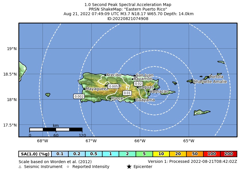 Spectral Acceleration |
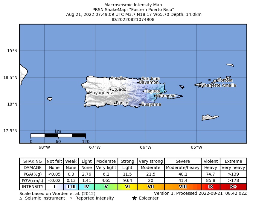 Intensity Map |
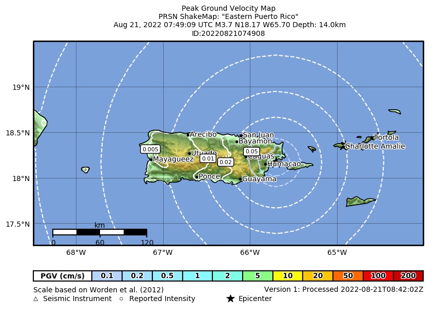 Peak Ground Velocity |
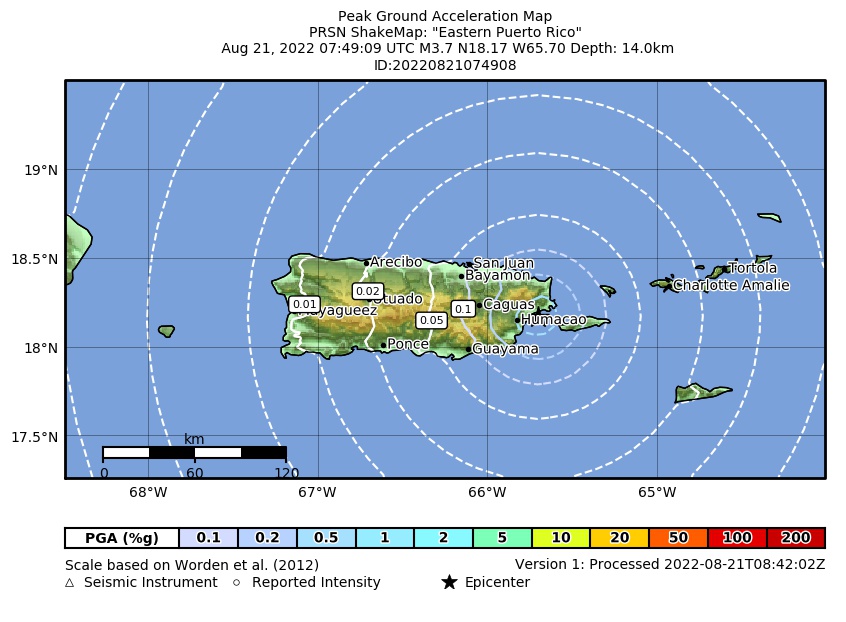 Peak Ground Acceleration |
 DYFI Map |
Google Map for this Event |