
This information is Issued for Puerto Rico and the Virgin Islands.For more information visit your corresponding Seismological Institution or theTsunami Warning Centers
| Event Details | |
|---|---|
| Estimated Maximum Intensity: | III in Yauco, PR |
| Date: |
September 01, 2022 03:36:55 UTC August 31, 2022 23:36:55 Hora Local |
| Region: | South Region of Puerto Rico |
| Distances: |
5.79 Km Southwest of Guayanilla,PR 7.36 Km South-Southeast of Yauco,PR 23.81 Km West-Southeast of Ponce,PR |
| Magnitude: | 3.35 Md |
| Location: | Latitude: 18.0195 Longitude: -66.8281 |
| Depth: | 17 Km |
| Tsunami Warning Level: | No Warning, Advisory or Watch is in effect for Puerto Rico and the Virgin Islands |
| Issued Date & Time | 2022-09-01 00:16:33 |
| ID: | 20220901033655 |
Epicentral Map
| BULLETIN 2 Seismic Event/Tsunami |
|
|---|---|
| DATE: | August 31, 2022 |
| LOCAL TIME: | 23:36:55 |
| LATITUDE: | 18.0195 N |
| LONGITUDE: | 66.8281 W |
| LOCATION: |
5.8 Km Southwest of Guayanilla,PR
23.8 Km West-Southeast of Ponce,PR |
| DEPTH: | 17 Km |
| MAGNITUDE: | 3.35 Md |
| ESTIMATED MAXIMUM INTENSITY: | III in Yauco, PR |
| TSUNAMI ALERT LEVEL: | No Warning, Advisory or Watch is in effect for Puerto Rico and the Virgin Islands |
| DATE & ISSUED TIME | 2022-09-01 00:16:37 |
|
The Puerto Rico Seismic Network (PRSN) received information that this
minor earthquake was reported as
felt in Adjuntas, Ponce and Yauco with a maximum
intensity of III (Modified Mercalli Scale, MM).
At the moment of generating this bulletin no damages has been reported, but given the size and location this can not be ruled out Based on magnitude, location and historic records the earthquake was not sufficient to generate a destructive tsunami to Puerto Rico and Virgin Islands. |
|

|
|
Technical Information
YEAR MO DA  --ORIGIN--  --LAT N-  --LON W--  DEPTH   RMS   ERH   ERZ  XMAG  FMAG  PMAG  INT
2022-09-01  0336 55.07  18  1.17   66 49.69  17.07  0.17  0.40  0.38        3.35  3.35D III
                                                                                         SOURCE
NSTA NPHS  DMIN MODEL GAP ITR NFM NWR NWS NVR REMRKS-AVH  N.XMG-XMMAD-T   N.FMG-FMMAD-T  L F X
  48   48   4.6  PR1  114  14  25  36  17  48     Q  PP0   0.00  0.00     24.00  0.23 D

XMAG2-N.XMG2-XMMAD-T-S  FMAG2-N.FMG2-FMMAD-T-S  PREF.MAG-N.PMAG-PRMAD-T
                         3.35  24.00  0.23 Z        3.35  24.00  0.23 D

REGION= Southern Puerto Rico

STA NET COM CR DIST AZM  AN P/S WT   SEC (TOBS -TCAL -DLY  =RES)  WT   SR  INFO  CAL DUR-W-FMAG-T -AMP-U-PER-W-XMAG-T
PR05 GS HHZ  A  4.6 312 162 IPD    58.21  3.14  3.01 0.00  0.13  1.58     0.129 0.55  60   2.92 Z
PR05 GS HH1  A  4.6 312 162 ES  1  60.99  5.92  5.36 0.00  0.56* 0.00S    0.000
PR02 GS HHZ  A  6.2  96 156 IPD    58.24  3.17  3.09 0.00  0.08  1.58     0.116 0.55  78   3.17 Z
PR02 GS HH2  A  6.2  96 156 ES  1  60.93  5.86  5.50 0.00  0.36  0.79S    0.105
GBPR PR HHZ  A  7.3 228 152 IPD    58.28  3.21  3.16 0.00  0.05  1.58     0.169 0.58  83   3.21 Z
GBPR PR HH1  A  7.3 228 152 ES  1  60.75  5.68  5.62 0.00  0.06  0.79S    0.108
PR06 GS HHZ  A 11.7  69 138 IPD    58.48  3.41  3.51 0.00 -0.10  1.58     0.108 0.55  60   2.96 Z
PR06 GS HH1  A 11.7  69 138 ES  1  61.27  6.20  6.25 0.00 -0.05  0.79S    0.109
PR03 GS HHZ  A 12.7 295 135 IPD    58.64  3.57  3.61 0.00 -0.04  1.58     0.125 0.55  65   3.04 Z
PR03 GS HH1  A 12.7 295 135 ES  1  61.60  6.53  6.43 0.00  0.10  0.79S    0.103
PR04 GS HHZ  A 17.3 105 124 IPD    59.17  4.10  4.10 0.00  0.00  1.58     0.136 0.55  54   2.90 Z
PR04 GS HH1  A 17.3 105 124 ES  1  62.47  7.40  7.30 0.00  0.10  0.79S    0.076
OBIP PR BHZ  A 23.6  83 113 EP+ 1  59.58  4.51  4.89 0.00 -0.38  0.79     0.028 0.87  68   2.95 Z
OBIP PR BHN  A 23.6  83 113 ES  1  63.49  8.42  8.70 0.00 -0.28  0.79S    0.072
PR01 GS HHZ  A 25.4 274 110 IPU    60.04  4.97  5.12 0.00 -0.15  1.58     0.188 0.55  70   3.19 Z
PR01 GS HH1  A 25.4 274 110 ES  1  63.81  8.74  9.11 0.00 -0.37  0.79S    0.090
CELP PR HHZ  A 27.1  76 108 IPD    60.22  5.15  5.33 0.00 -0.18  1.58     0.117 0.55  82   3.34 Z
CELP PR HH1  A 27.1  76 108 ES  1  63.88  8.81  9.49 0.00 -0.68* 0.00S    0.000
UUPR PR HHZ  A 28.2  23 107 IPD    60.61  5.54  5.49 0.00  0.05  1.58     0.163 0.55  71   3.22 Z
UUPR PR HH1  A 28.2  23 107 ES  1  64.61  9.54  9.77 0.00 -0.23  0.79S    0.156
CRPR PR HHZ  A 29.8 268 105 IPU    60.51  5.44  5.71 0.00 -0.27  1.58     0.229 0.55  84   3.38 Z
CRPR PR HH1  A 29.8 268 105 ES  1  64.60  9.53 10.16 0.00 -0.63* 0.00S    0.000
ICMP PR HHZ  A 35.2 114 101 IPU    61.44  6.37  6.44 0.00 -0.07  1.58     0.250 0.55  79   3.36 Z
ICMP PR HH1  A 35.2 114 101 ES  1  66.59 11.52 11.46 0.00  0.06  0.79S    0.114
AOPR PR HHZ  A 37.0  12 100 IPU    61.80  6.73  6.69 0.00  0.04  1.58     0.175 0.55  81   3.39 Z
AOPR PR HH2  A 37.0  12 100 ES  1  66.87 11.80 11.91 0.00 -0.11  0.79S    0.158
PRSN PR HHZ  A 40.0 304  99 EP+ 1  62.03  6.96  7.11 0.00 -0.15  0.79     0.039 0.55  65   3.21 Z
PRSN PR HH1  A 40.0 304  99 ES  1  67.60 12.53 12.66 0.00 -0.13  0.79S    0.090
AGPR PR HHZ  A 57.9 329  63 IPU    64.98  9.91  9.58 0.00  0.33  1.54     0.255 0.55 100   3.62 Z
AGPR PR HH1  A 57.9 329  63 ES  1  72.10 17.03 17.05 0.00 -0.02  0.77S    0.132
ECPR PR HHZ  A 59.3  55  63 EP+ 1  64.62  9.55  9.76 0.00 -0.21  0.76     0.060 0.55 104   3.66 Z
ECPR PR HH1  A 59.3  55  63 ES  1  72.52 17.45 17.37 0.00  0.08  0.76S    0.123
EMPR PR HHZ  A 59.7  31  63 EP- 1  65.57 10.50  9.81 0.00  0.69* 0.00     0.000 0.55 119   3.78 Z
EMPR PR HH2  A 59.7  31  63 ES  1  73.13 18.06 17.46 0.00  0.60* 0.00S    0.000
SJG  IU BHZ  A 72.5  81  63 EP+ 1  66.75 11.68 11.43 0.00  0.25  0.54     0.038 0.73  79   3.30 Z
SJG  IU BH1  A 72.5  81  63 ES  1  74.95 19.88 20.35 0.00 -0.47  0.29S    0.020
IGPR PR HHZ  A 76.6  94  63 IPU    67.28 12.21 11.95 0.00  0.26  0.89     0.122 0.55  85   3.49 Z
IGPR PR HH2  A 76.6  94  63 ES  1  76.78 21.71 21.27 0.00  0.44  0.32S    0.030
IDE  PR EHZ  A 78.8 302  63 IPD    67.87 12.80 12.22 0.00  0.58* 0.00     0.000 0.58  91   3.53 Z
IDE  PR EHN  A 78.8 302  63 ES  1  77.23 22.16 21.75 0.00  0.41  0.36S    0.031
GCPR PR HHZ  A 85.0  67  63 EP+ 1  68.28 13.21 13.02 0.00  0.19  0.25     0.007 0.55  98   3.63 Z
GCPR PR HH1  A 85.0  67  63 ES  1  78.30 23.23 23.18 0.00  0.05  0.25S    0.013
HUMP PR HHZ  A104.6  82  63 EP- 1  71.16 16.09 15.49 0.00  0.60* 0.00     0.000 0.55 113   3.78 Z
HUMP PR HH1  A104.6  82  63 ES  1  83.24 28.17 27.57 0.00  0.60* 0.00S    0.000
IMPR PR HHZ  A117.0 274  63 EP+ 1  72.79 17.72 17.06 0.00  0.66* 0.00     0.000
MTP  PR HHZ  A135.3  86  63 EP+ 2  75.90 20.83 19.38 0.00  1.45* 0.00     0.000 0.55  96   3.67 Z
CUPR PR HHZ  A166.6  78  63 EP- 2  80.84 25.77 23.34 0.00  2.43* 0.00     0.000 0.55 141   4.05 Z
CUPR PR HH2  A166.6  78  63 ES  2  98.42 43.35 41.55 0.00  1.80* 0.00S    0.000
Event Maps
 Spectral Acceleration |
 Intensity Map |
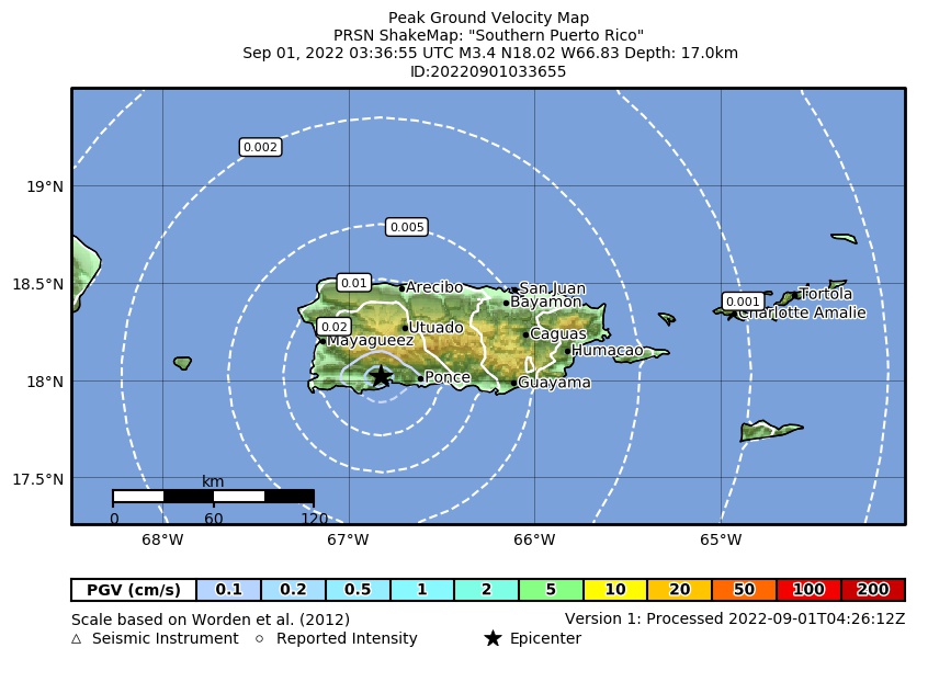 Peak Ground Velocity |
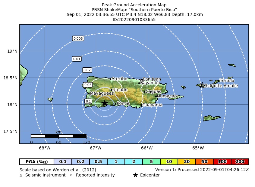 Peak Ground Acceleration |
 DYFI Map |
Google Map for this Event |