
This information is Issued for Puerto Rico and the Virgin Islands.For more information visit your corresponding Seismological Institution or theTsunami Warning Centers
| Event Details | |
|---|---|
| Estimated Maximum Intensity: | V in Isabela, PR |
| Date: |
December 30, 2022 18:49:25 UTC December 30, 2022 14:49:25 Hora Local |
| Region: | Northern Puerto Rico |
| Distances: |
21.12 Km North-Northeast of Aguadilla,PR 21.37 Km North of Isabela,PR 48.24 Km West-Northwest of Arecibo,PR |
| Magnitude: | 4.18 Md |
| Location: | Latitude: 18.6438 Longitude: -67.0435 |
| Depth: | 108 Km |
| Tsunami Warning Level: | No Warning, Advisory or Watch is in effect for Puerto Rico and the Virgin Islands |
| Issued Date & Time | 2022-12-30 15:12:55 |
| ID: | 20221230184925 |
Epicentral Map
| BULLETIN 2 Seismic Event/Tsunami |
|
|---|---|
| DATE: | December 30, 2022 |
| LOCAL TIME: | 14:49:25 |
| LATITUDE: | 18.6438 N |
| LONGITUDE: | 67.0435 W |
| LOCATION: |
21.1 Km North-Northeast of Aguadilla,PR
48.2 Km West-Northwest of Arecibo,PR |
| DEPTH: | 108 Km |
| MAGNITUDE: | 4.18 Md |
| ESTIMATED MAXIMUM INTENSITY: | V in Isabela, PR |
| TSUNAMI ALERT LEVEL: | No Warning, Advisory or Watch is in effect for Puerto Rico and the Virgin Islands |
| DATE & ISSUED TIME | 2022-12-30 15:13:00 |
|
The Puerto Rico Seismic Network (PRSN) received information that this
light earthquake was reported as
felt in the Central region of Puerto Rico, the Northern region of Puerto Rico and the Western region of Puerto Rico with a maximum
intensity of V (Modified Mercalli Scale, MM).
At the moment of generating this bulletin no damages has been reported and are not expected to occur Based on magnitude, location and historic records the earthquake was not sufficient to generate a destructive tsunami to Puerto Rico and Virgin Islands. |
|

|
|
Technical Information
YEAR MO DA  --ORIGIN--  --LAT N-  --LON W--  DEPTH   RMS   ERH   ERZ  XMAG  FMAG  PMAG  INT
2022-12-30  1849 25.07  18 38.63   67  2.61 108.11  0.25  1.47  0.94        4.18  4.18D V
                                                                                         SOURCE
NSTA NPHS  DMIN MODEL GAP ITR NFM NWR NWS NVR REMRKS-AVH  N.XMG-XMMAD-T   N.FMG-FMMAD-T  L F X
  56   56  20.8  PR1  231  20  28  34  16  56     Q  PPT   0.00  0.00     25.00  0.11 D

XMAG2-N.XMG2-XMMAD-T-S  FMAG2-N.FMG2-FMMAD-T-S  PREF.MAG-N.PMAG-PRMAD-T
                         4.18  25.00  0.11 Z        4.18  25.00  0.11 D

REGION= North of Puerto Rico

STA NET COM CR DIST AZM  AN P/S WT   SEC (TOBS -TCAL -DLY  =RES)  WT   SR  INFO  CAL DUR-W-FMAG-T -AMP-U-PER-W-XMAG-T
AGPR PR HHZ  A 20.8 201 168 EP+ 1  39.81 14.74 14.74 0.00  0.00  1.24     0.111 0.55 140   3.96 Z
AGPR PR HH1  A 20.8 201 168 ES  1  51.17 26.10 26.24 0.00 -0.14  1.24S    0.397
AOPR PR HHZ  A 44.9 137 156 EP+ 1  40.42 15.35 15.66 0.00 -0.31  1.24     0.078 0.55 181   4.31 Z
AOPR PR HH2  A 44.9 137 156 ES  1  53.22 28.15 27.87 0.00  0.28  1.24S    0.190
PRSN PR HHZ  A 48.4 193 154 EP+ 1  40.48 15.41 15.84 0.00 -0.43  1.24     0.056 0.55 147   4.13 Z
PRSN PR HH1  A 48.4 193 154 ES  1  52.51 27.44 28.20 0.00 -0.76* 0.13S    0.001
LSP  PR HHZ  A 52.0 185 153 EP- 1  40.68 15.61 16.04 0.00 -0.43  1.24     0.052 0.58 180   4.29 Z
LSP  PR HH2  A 52.0 185 153 ES  1  53.73 28.66 28.55 0.00  0.11  1.24S    0.149
IDE  PR EHZ  A 53.1 238 152 IPU    41.42 16.35 16.10 0.00  0.25  2.48     0.520 0.58 162   4.20 Z
UUPR PR HHZ  A 55.1 141 151 EP+ 1  41.28 16.21 16.22 0.00 -0.01  1.24     0.066 0.55 151   4.16 Z
UUPR PR HH2  A 55.1 141 151 ES  1  53.69 28.62 28.87 0.00 -0.25  1.24S    0.124
PR03 GS HHZ  A 64.9 170 147 EP+ 1  41.82 16.75 16.84 0.00 -0.09  1.24     0.060 0.55 132   4.05 Z
PR03 GS HH2  A 64.9 170 147 ES  1  55.13 30.06 29.98 0.00  0.08  1.24S    0.119
PR05 GS HHZ  A 68.9 163 146 EP+ 1  42.22 17.15 17.12 0.00  0.03  1.24     0.065
PR05 GS HH1  A 68.9 163 146 ES  1  55.78 30.71 30.47 0.00  0.24  1.24S    0.111
CRPR PR HHZ  A 70.9 186 145 EP+ 1  42.14 17.07 17.27 0.00 -0.20  1.24     0.083 0.55 147   4.15 Z
CRPR PR HH2  A 70.9 186 145 ES  1  54.91 29.84 30.74 0.00 -0.90* 0.00S    0.000
PR06 GS HHZ  A 73.3 152 144 EP+ 1  42.60 17.53 17.44 0.00  0.09  1.24     0.074
PR06 GS HH1  A 73.3 152 144 ES  1  56.19 31.12 31.04 0.00  0.08  1.24S    0.102
MLPR PR HHZ  A 74.6 181 143 EP- 1  42.30 17.23 17.54 0.00 -0.31  1.24     0.089 0.55 136   4.08 Z
MLPR PR HH1  A 74.6 181 143 ES  1  56.03 30.96 31.22 0.00 -0.26  1.24S    0.198
PR02 GS HHZ  A 75.6 157 143 EP+ 1  43.10 18.03 17.61 0.00  0.42  1.24     0.077 0.55 136   4.09 Z
PR02 GS HH1  A 75.6 157 143 ES  1  56.93 31.86 31.35 0.00  0.51* 1.24S    0.116
GBPR PR HHZ  A 76.0 166 143 EP+ 1  43.07 18.00 17.64 0.00  0.36  1.23     0.081 0.58 171   4.27 Z
GBPR PR HH2  A 76.0 166 143 ES  1  56.49 31.42 31.40 0.00  0.02  1.23S    0.145
CELP PR HHZ  A 79.9 141 142 EP+ 1  42.92 17.85 17.94 0.00 -0.09  1.21     0.088
CELP PR HH1  A 79.9 141 142 ES  1  56.62 31.55 31.93 0.00 -0.38  1.21S    0.110
ECPR PR HHZ  A 80.4 116 141 EP+ 1  43.01 17.94 17.98 0.00 -0.04  1.21     0.148 0.55 182   4.36 Z
ECPR PR HH2  A 80.4 116 141 ES  1  57.05 31.98 32.00 0.00 -0.02  1.21S    0.255
GCPR PR HHZ  A107.9 109 133 EP+ 1  45.64 20.57 20.34 0.00  0.23  0.65     0.064 0.55 152   4.22 Z
GCPR PR HH1  A107.9 109 133 ES  1  61.43 36.36 36.21 0.00  0.15  0.65S    0.109
SJG  IU BHZ  A111.3 121 132 EP+ 1  45.82 20.75 20.65 0.00  0.10  0.56     0.039 0.73 142   4.04 Z
SJG  IU BH2  A111.3 121 132 ES  1  61.63 36.56 36.76 0.00 -0.20  0.56S    0.055
IMPR PR HHZ  A112.9 237 131 EP- 1  45.30 20.23 20.80 0.00 -0.57* 0.51     0.038 0.55 123   4.04 Z
IMPR PR HH2  A112.9 237 131 ES  1  61.32 36.25 37.02 0.00 -0.77* 0.03S    0.000
IGPR PR HHZ  A124.3 127 129 EP+ 1  47.72 22.65 21.90 0.00  0.75* 0.04     0.000 0.55 157   4.27 Z
IGPR PR HH2  A124.3 127 129 ES  1  64.62 39.55 38.98 0.00  0.57* 0.24S    0.010
HUMP PR HHZ  A137.9 113 126 EP+ 1  48.74 23.67 23.27 0.00  0.40  0.03     0.000 0.55 167   4.34 Z
HUMP PR HH2  A137.9 113 126 ES  1  66.72 41.65 41.42 0.00  0.23  0.03S    0.000
PCDR PR BHZ  A141.9 265 125 EP- 1  47.55 22.48 23.68 0.00 -1.20* 0.00     0.000 0.55 139   4.18 Z
PCDR PR BHN  A141.9 265 125 ES  1  64.85 39.78 42.15 0.00 -2.37* 0.00S    0.000
MTP  PR HHZ  A168.8 110 120 EP+ 1  52.22 27.15 26.54 0.00  0.61* 0.00     0.000 0.55 156   4.31 Z
MTP  PR HH1  A168.8 110 120 ES  1  73.51 48.44 47.24 0.00  1.20* 0.00S    0.000
CUPR PR HHZ  A189.7 101 117 EP- 1  53.99 28.92 28.86 0.00  0.06  0.00     0.000 0.55 146   4.28 Z
CUPR PR HH2  A189.7 101 117 ES  1  76.24 51.17 51.37 0.00 -0.20  0.00S    0.000
STVI PR HHZ  A222.8  97 113 EP+ 2  57.78 32.71 32.64 0.00  0.07  0.00     0.000 0.55 139   4.27 Z
STVI PR HH1  A222.8  97 113 ES  2  82.90 57.83 58.10 0.00 -0.27  0.00S    0.000
SMDR PR BHZ  A236.9 288 112 EP- 1  57.26 32.19 34.29 0.00 -2.10* 0.00     0.000 0.00 131   3.37 Z
SMDR PR BHE  A236.9 288 112 ES  1  82.15 57.08 61.04 0.00 -3.96* 0.00S    0.000
SJVI PR HHZ  A242.5  97 111 EP+ 1  60.14 35.07 34.93 0.00  0.14  0.00     0.000 0.55 147   4.34 Z
SJVI PR HH1  A242.5  97 111 ES  1  88.55 63.48 62.18 0.00  1.30* 0.00S    0.000
CDVI PR HH2  A260.6 111 110 ES  2  91.37 66.30 65.98 0.00  0.32  0.00S    0.000
SDD  DR BHZ  A304.1 267 107 EP+ 1  65.99 40.92 42.29 0.00 -1.37* 0.00     0.000 0.73 112   4.04 Z
SDD  DR BHN  A304.1 267 107 ES  1  98.08 73.01 75.28 0.00 -2.27* 0.00S    0.000
SDDR CU BHZ  A449.3 276 101 EP- 1  83.39 58.32 60.10 0.00 -1.78* 0.00     0.000 0.00 168   3.89 Z
SDDR CU BH1  A449.3 276 101 ES  1 127.09102.02106.98 0.00 -4.96* 0.00S    0.000
Event Maps
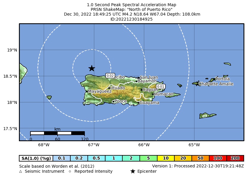 Spectral Acceleration |
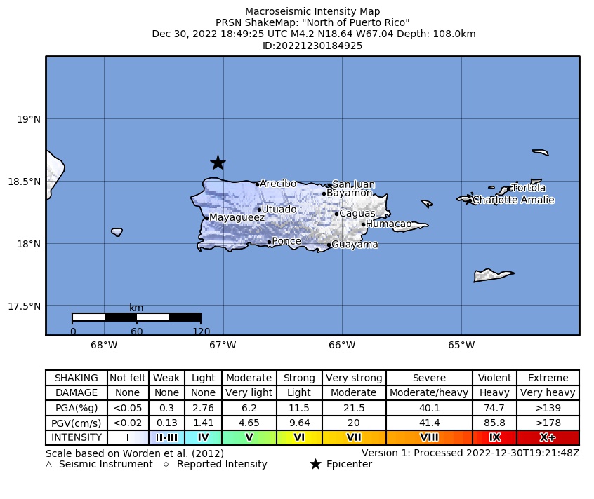 Intensity Map |
 Peak Ground Velocity |
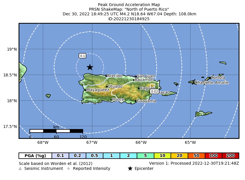 Peak Ground Acceleration |
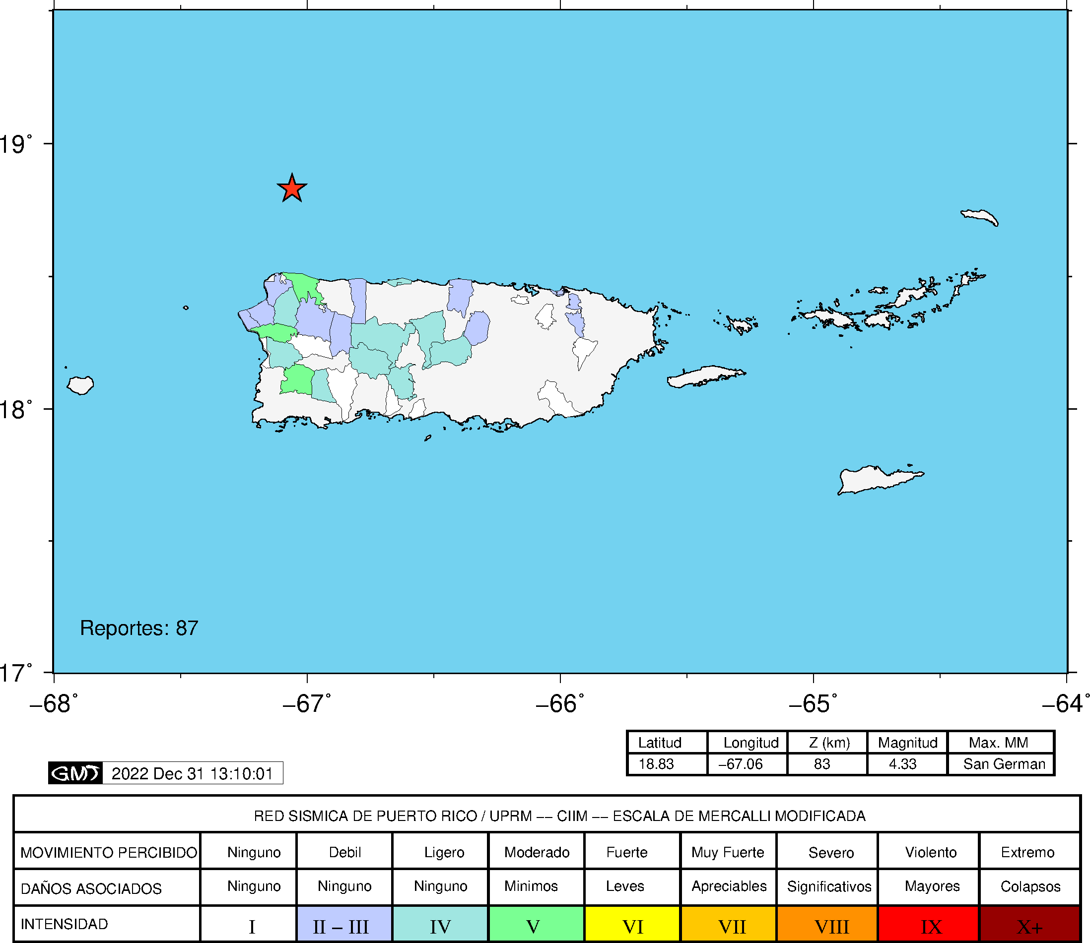 DYFI Map |
Google Map for this Event |