
This information is Issued for Puerto Rico and the Virgin Islands.For more information visit your corresponding Seismological Institution or theTsunami Warning Centers
| Event Details | |
|---|---|
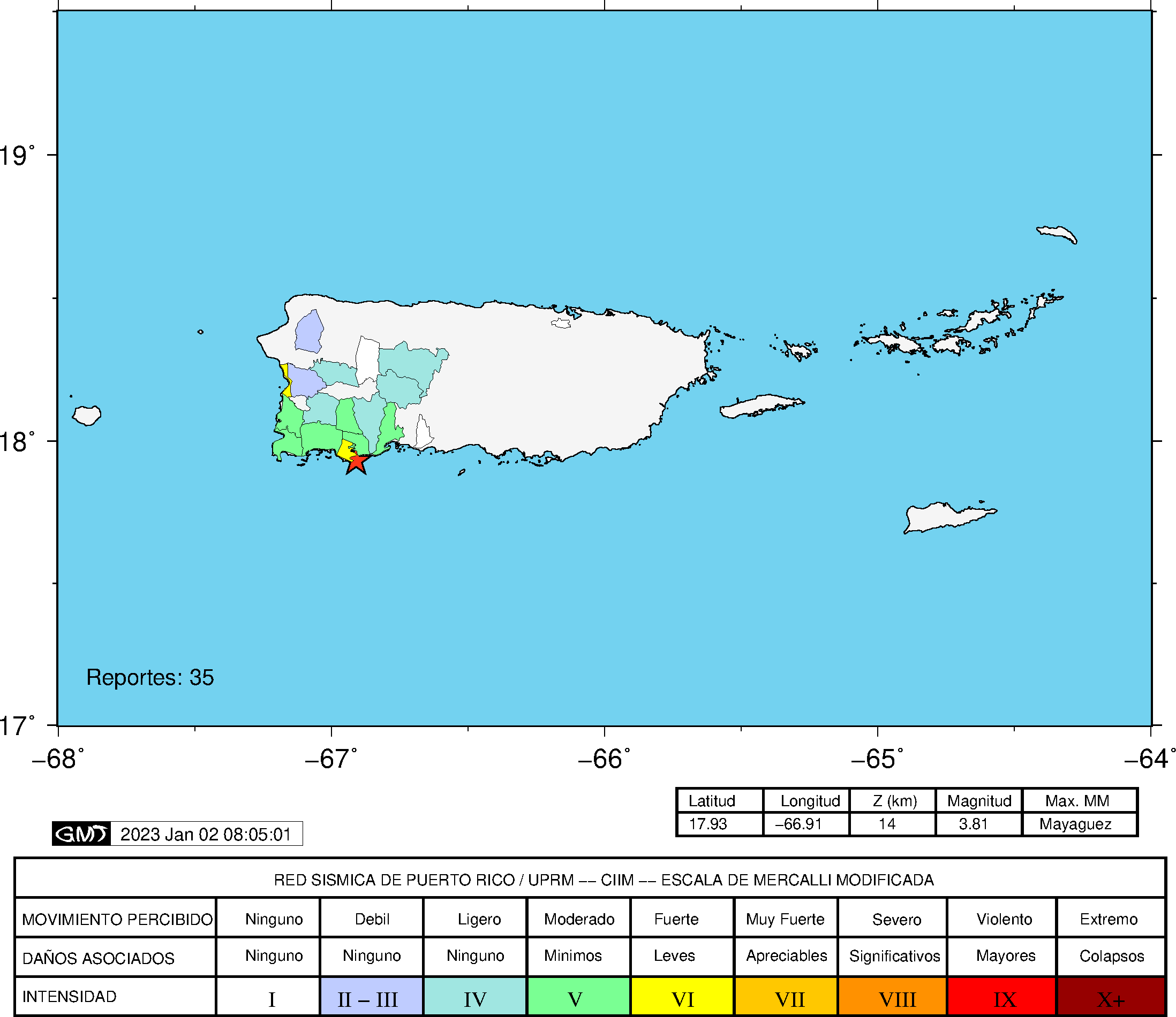
| Estimated Maximum Intensity: | IV in Lajas, PR |
| Date: |
January 01, 2023 09:06:48 UTC January 01, 2023 05:06:48 Hora Local |
| Region: | South Region of Puerto Rico |
| Distances: |
7.01 Km South of Guánica,PR 16.92 Km Southeast of Lajas,PR 36.39 Km West-Southeast of Ponce,PR |
| Magnitude: | 3.81 Md |
| Location: | Latitude: 17.9266 Longitude: -66.9146 |
| Depth: | 14 Km |
| Tsunami Warning Level: | No Warning, Advisory or Watch is in effect for Puerto Rico and the Virgin Islands |
| Issued Date & Time | 2023-01-01 05:37:19 |
| ID: | 20230101090647 |
Epicentral Map
| BULLETIN 2 Seismic Event/Tsunami |
|
|---|---|
| DATE: | January 01, 2023 |
| LOCAL TIME: | 05:06:48 |
| LATITUDE: | 17.9266 N |
| LONGITUDE: | 66.9146 W |
| LOCATION: |
7 Km South of Guánica,PR
36.4 Km West-Southeast of Ponce,PR |
| DEPTH: | 14 Km |
| MAGNITUDE: | 3.81 Md |
| ESTIMATED MAXIMUM INTENSITY: | IV in Lajas, PR |
| TSUNAMI ALERT LEVEL: | No Warning, Advisory or Watch is in effect for Puerto Rico and the Virgin Islands |
| DATE & ISSUED TIME | 2023-01-01 05:37:26 |
|
The Puerto Rico Seismic Network (PRSN) received information that this
minor earthquake was reported as
felt in the Western region of Puerto Rico and the Southern region of Puerto Rico with a maximum
intensity of IV (Modified Mercalli Scale, MM).
At the moment of generating this bulletin no damages has been reported, but given the size and location this can not be ruled out Based on magnitude, location and historic records the earthquake was not sufficient to generate a destructive tsunami to Puerto Rico and Virgin Islands. |
|

|
|
Technical Information
YEAR MO DA  --ORIGIN--  --LAT N-  --LON W--  DEPTH   RMS   ERH   ERZ  XMAG  FMAG  PMAG  INT
2023-01-01  0906 48.15  17 55.60   66 54.88  14.21  0.12  0.65  0.52        3.81  3.81D IV
                                                                                         SOURCE
NSTA NPHS  DMIN MODEL GAP ITR NFM NWR NWS NVR REMRKS-AVH  N.XMG-XMMAD-T   N.FMG-FMMAD-T  L F X
  49   49   6.5  PR1  225  16  27  26  11  49     Q  PPY   0.00  0.00     22.00  0.13 D

XMAG2-N.XMG2-XMMAD-T-S  FMAG2-N.FMG2-FMMAD-T-S  PREF.MAG-N.PMAG-PRMAD-T
                         3.81  22.00  0.13 Z        3.81  22.00  0.13 D

REGION= Southern Puerto Rico

STA NET COM CR DIST AZM  AN P/S WT   SEC (TOBS -TCAL -DLY  =RES)  WT   SR  INFO  CAL DUR-W-FMAG-T -AMP-U-PER-W-XMAG-T
GBPR PR HHZ  A  6.5  34 149 IPD    50.98  2.83  2.75 0.00  0.08  1.36     0.293 0.58 138   3.67 Z
GBPR PR HH1  A  6.5  34 149 ES  1  53.10  4.95  4.89 0.00  0.06  0.68S    0.243
PR05 GS HHZ  A 14.5  23 120 IPD    51.73  3.58  3.55 0.00  0.03  1.36     0.116
PR05 GS HH1  A 14.5  23 120 ES  1  54.70  6.55  6.32 0.00  0.23  0.68S    0.192
MLPR PR HHZ  A 14.5 290 120 IPU    51.68  3.53  3.55 0.00 -0.02  1.36     0.284 0.55 123   3.63 Z
MLPR PR HH2  A 14.5 290 120 ES  1  54.40  6.25  6.32 0.00 -0.07  0.68S    0.129
PR03 GS HHZ  A 15.7 352 117 IPD    51.69  3.54  3.70 0.00 -0.16  1.36     0.108 0.55 106   3.50 Z
PR03 GS HH2  A 15.7 352 117 ES  1  54.42  6.27  6.59 0.00 -0.32  0.46S    0.094
PR02 GS HHZ  A 18.1  58 110 IPD    52.22  4.07  4.00 0.00  0.07  1.36     0.160 0.55  85   3.32 Z
PR02 GS HH1  A 18.1  58 110 ES  1  55.48  7.33  7.12 0.00  0.21  0.68S    0.098
PR01 GS HHZ  A 20.1 307 105 IPU    52.28  4.13  4.28 0.00 -0.15  1.36     0.144
PR01 GS HH1  A 20.1 307 105 ES  1  55.22  7.07  7.62 0.00 -0.55* 0.00S    0.000
CRPR PR HHZ  A 22.5 294  99 IPU    52.80  4.65  4.60 0.00  0.05  1.36     0.243 0.55 127   3.71 Z
CRPR PR HH2  A 22.5 294  99 ES  1  56.04  7.89  8.19 0.00 -0.30  0.58S    0.063
PR06 GS HHZ  A 24.7  54  94 IPD    52.94  4.79  4.91 0.00 -0.12  1.36     0.155 0.55  88   3.39 Z
PR06 GS HH2  A 24.7  54  94 ES  1  56.65  8.50  8.74 0.00 -0.24  0.68S    0.090
LSP  PR HHZ  A 33.0 327  91 IPU    54.28  6.13  6.08 0.00  0.05  1.36     0.129 0.58 133   3.80 Z
LSP  PR HH1  A 33.0 327  91 ES  1  59.10 10.95 10.82 0.00  0.13  0.68S    0.144
CELP PR HHZ  A 39.1  65  90 IPD    55.03  6.88  6.95 0.00 -0.07  1.36     0.246 0.55 122   3.78 Z
CELP PR HH1  A 39.1  65  90 ES  1  60.44 12.29 12.37 0.00 -0.08  0.68S    0.091
PRSN PR HHZ  A 40.4 323  90 IPU    55.30  7.15  7.12 0.00  0.03  1.36     0.138 0.55 100   3.60 Z
PRSN PR HH2  A 40.4 323  90 ES  1  60.75 12.60 12.67 0.00 -0.07  0.68S    0.133
UUPR PR HHZ  A 41.6  29  90 IPD    55.40  7.25  7.29 0.00 -0.04  1.36     0.126 0.55 113   3.71 Z
UUPR PR HH2  A 41.6  29  90 ES  1  60.55 12.40 12.98 0.00 -0.58* 0.00S    0.000
AOPR PR HHZ  A 49.5  20  90 IPD    56.48  8.33  8.41 0.00 -0.08  1.36     0.129 0.55 138   3.90 Z
AOPR PR HH1  A 49.5  20  90 ES  1  62.59 14.44 14.97 0.00 -0.53* 0.00S    0.000
AGPR PR HHZ  A 63.4 341  90 IPD    58.77 10.62 10.36 0.00  0.26  1.22     0.106 0.55 123   3.81 Z
AGPR PR HH1  A 63.4 341  90 ES  1  66.66 18.51 18.44 0.00  0.07  0.61S    0.150
ECPR PR HHZ  A 72.8  53  63 IPD    59.93 11.78 11.64 0.00  0.14  0.92     0.182 0.55 144   3.97 Z
ECPR PR HH1  A 72.8  53  63 ES  3  68.08 19.93 20.72 0.00 -0.79* 0.00S    0.000
IDE  PR EHZ  A 77.4 312  63 IPD    60.85 12.70 12.22 0.00  0.48  0.00     0.000
IDE  PR EHE  A 77.4 312  63 ES  1  70.64 22.49 21.75 0.00  0.74* 0.00S    0.000
SJG  IU BHZ  A 83.5  75  63 IPD    61.65 13.50 13.00 0.00  0.50  0.00     0.000 0.73 103   3.55 Z
SJG  IU BH1  A 83.5  75  63 ES  1  72.07 23.92 23.14 0.00  0.78* 0.00S    0.000
IGPR PR HHZ  A 85.7  86  63 IPU    62.23 14.08 13.27 0.00  0.81* 0.00     0.000 0.55 129   3.88 Z
IGPR PR HH1  A 85.7  86  63 ES  1  73.00 24.85 23.62 0.00  1.23* 0.00S    0.000
GCPR PR HHZ  A 97.6  64  63 IPD    63.39 15.24 14.78 0.00  0.46  0.00     0.000 0.55 122   3.84 Z
GCPR PR HH1  A 97.6  64  63 ES  1  74.35 26.20 26.31 0.00 -0.11  0.03S    0.000
IMPR PR HHZ  A108.9 279  63 EP- 3  65.58 17.43 16.22 0.00  1.21* 0.00     0.000
HUMP PR HHZ  A115.4  77  63 EP+ 2  66.08 17.93 17.03 0.00  0.90* 0.00     0.000 0.55 131   3.93 Z
HUMP PR HH2  A115.4  77  63 ES  1  79.97 31.82 30.31 0.00  1.51* 0.00S    0.000
MTP  PR HHZ  A145.5  82  63 EP- 3  70.68 22.53 20.84 0.00  1.69* 0.00     0.000 0.55 128   3.94 Z
MTP  PR HH1  A145.5  82  63 ES  3  87.19 39.04 37.10 0.00  1.94* 0.00S    0.000
PCDR PR BHZ  A168.2 293  63 EP- 3  74.15 26.00 23.72 0.00  2.28* 0.00     0.000 0.55 121   3.92 Z
CUPR PR HHZ  A177.8  76  63 EP+ 3  76.13 27.98 24.94 0.00  3.04* 0.00     0.000 0.55 135   4.03 Z
CUPR PR HH2  A177.8  76  63 ES  3  96.14 47.99 44.39 0.00  3.60* 0.00S    0.000
STVI PR HHZ  A212.5  76  63 EP- 3  81.58 33.43 29.33 0.00  4.10* 0.00     0.000 0.55 110   3.88 Z
CDVI PR HHZ  A228.8  94  63 EP- 3  80.48 32.33 31.39 0.00  0.94* 0.00     0.000 0.55 124   4.00 Z
SJVI PR HHZ  A231.2  78  63 EP+ 3  82.89 34.74 31.69 0.00  3.05* 0.00     0.000
Event Maps
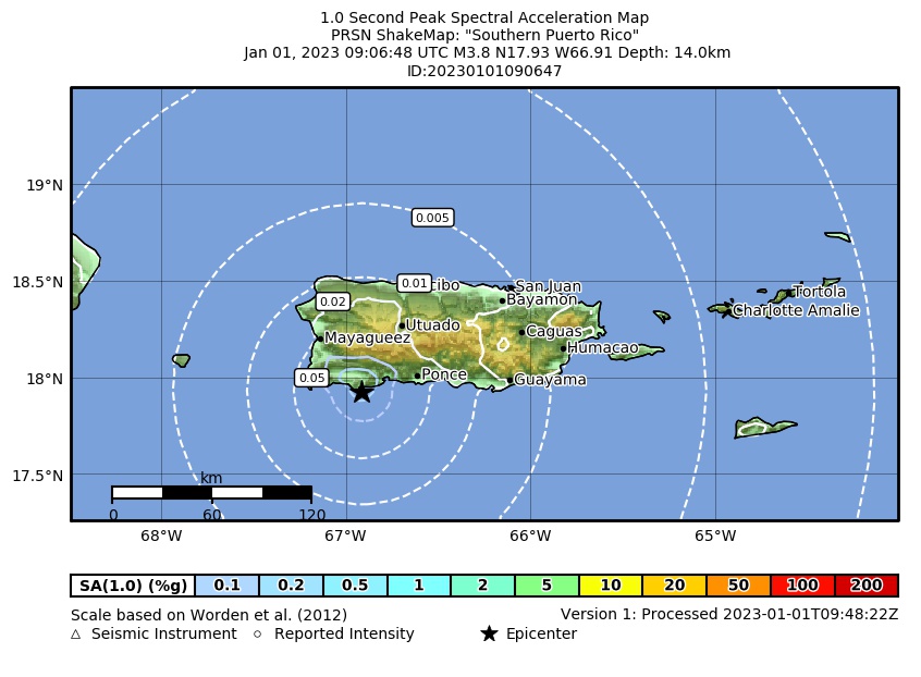 Spectral Acceleration |
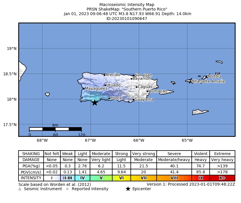 Intensity Map |
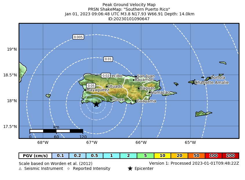 Peak Ground Velocity |
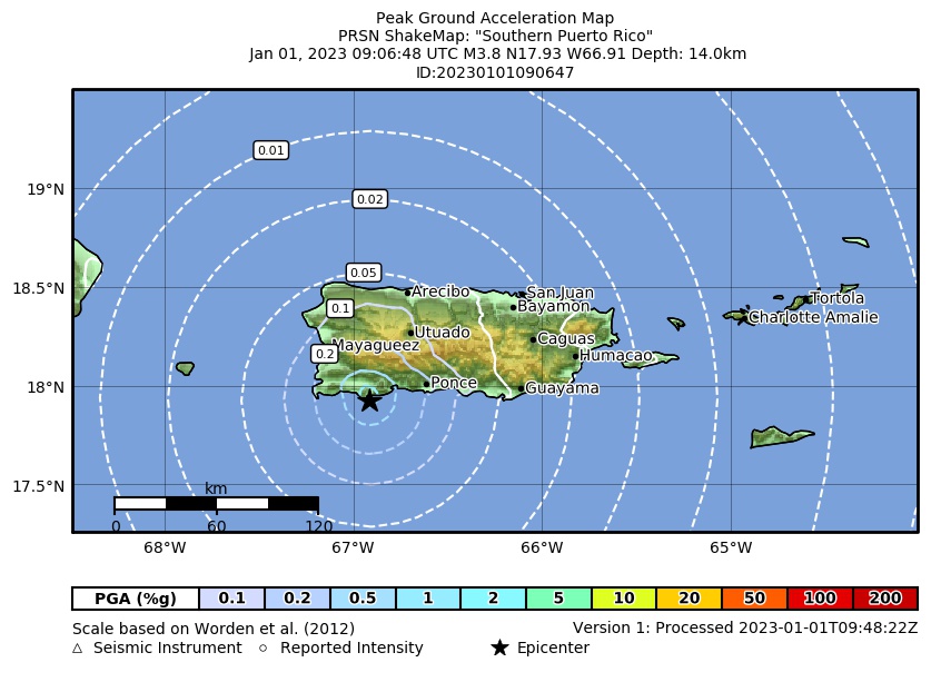 Peak Ground Acceleration |
 DYFI Map |
Google Map for this Event |