
This information is Issued for Puerto Rico and the Virgin Islands.For more information visit your corresponding Seismological Institution or theTsunami Warning Centers
| Event Details | |
|---|---|
| Estimated Maximum Intensity: | IV in Fajardo, PR |
| Date: |
January 08, 2023 06:59:38 UTC January 08, 2023 02:59:38 Hora Local |
| Region: | Sombrero Seismic Zone |
| Distances: |
75.18 Km North of Charlotte Amalie, St. Thomas,USVI 79.55 Km North-Northeast of Culebra,PR 128.07 Km East-Northeast of San Juan,PR |
| Magnitude: | 4.16 Md |
| Location: | Latitude: 19.0126 Longitude: -65.0768 |
| Depth: | 23 Km |
| Tsunami Warning Level: | No Warning, Advisory or Watch is in effect for Puerto Rico and the Virgin Islands |
| Issued Date & Time | 2023-01-08 03:58:00 |
| ID: | 20230108065932 |
Epicentral Map
| BULLETIN 2 Seismic Event/Tsunami |
|
|---|---|
| DATE: | January 08, 2023 |
| LOCAL TIME: | 02:59:38 |
| LATITUDE: | 19.0126 N |
| LONGITUDE: | 65.0768 W |
| LOCATION: |
75.2 Km North of Charlotte Amalie, St. Thomas,USVI
128.1 Km East-Northeast of San Juan,PR |
| DEPTH: | 23 Km |
| MAGNITUDE: | 4.16 Md |
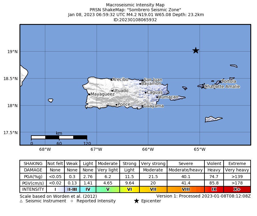
| ESTIMATED MAXIMUM INTENSITY: | IV in Fajardo, PR |
| TSUNAMI ALERT LEVEL: | No Warning, Advisory or Watch is in effect for Puerto Rico and the Virgin Islands |
| DATE & ISSUED TIME | 2023-01-08 03:58:06 |
|
The Puerto Rico Seismic Network (PRSN) received information that this
light earthquake was reported as
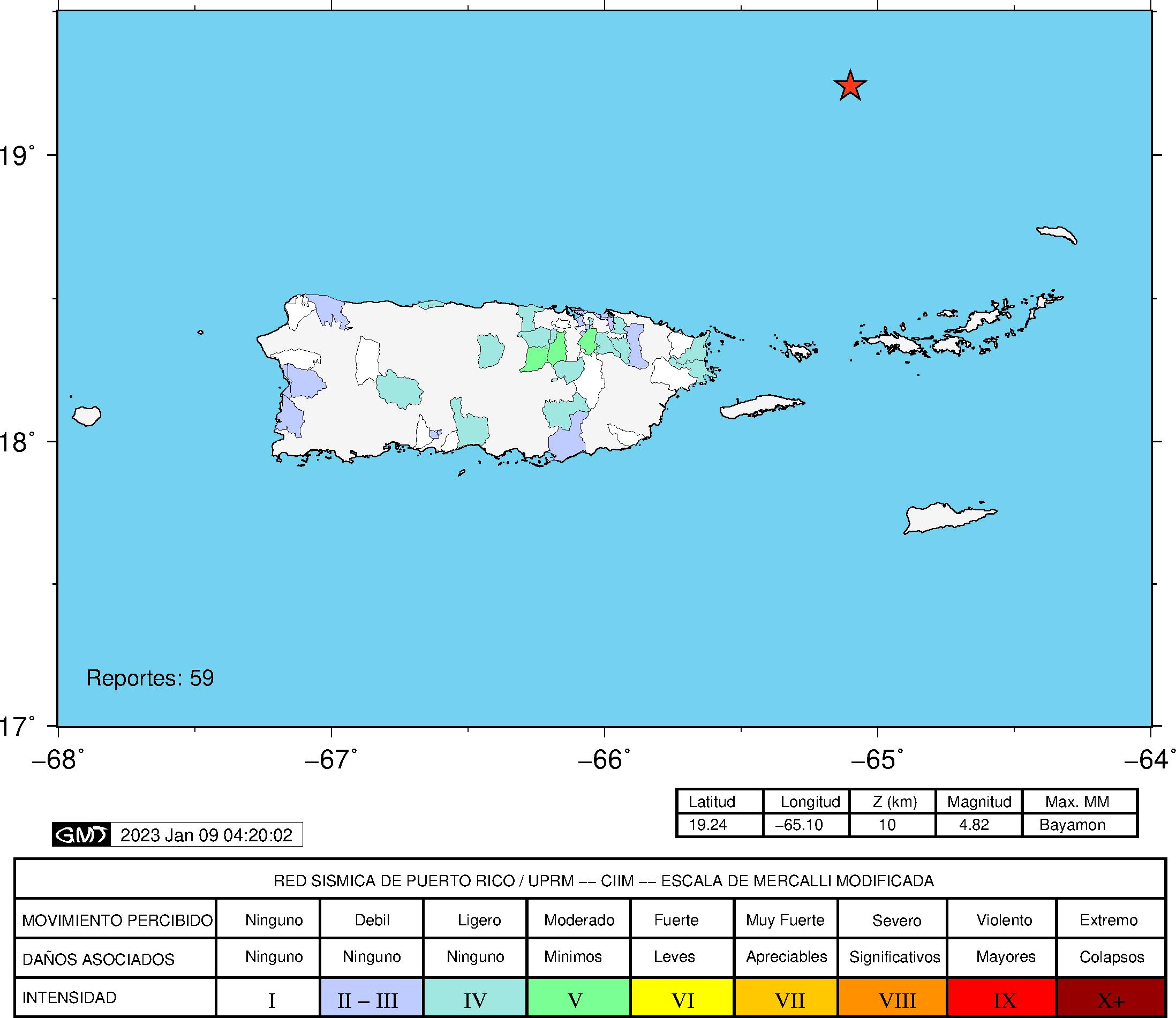
felt in the Eastern region of Puerto Rico and the Northern region of Puerto Rico with a maximum
intensity of IV (Modified Mercalli Scale, MM).
At the moment of generating this bulletin no damages has been reported and are not expected to occur Based on magnitude, location and historic records the earthquake was not sufficient to generate a destructive tsunami to Puerto Rico and Virgin Islands. |
|

|
|
Technical Information
YEAR MO DA  --ORIGIN--  --LAT N-  --LON W--  DEPTH   RMS   ERH   ERZ  XMAG  FMAG  PMAG  INT
2023-01-08  0659 38.66  19  0.76   65  4.61  23.17  0.18  0.71 13.50        4.16  4.16D
                                                                                         SOURCE
NSTA NPHS  DMIN MODEL GAP ITR NFM NWR NWS NVR REMRKS-AVH  N.XMG-XMMAD-T   N.FMG-FMMAD-T  L F X
  57   57  74.2  PR1  201  14  31  48  24  57     Q- PP0   0.00  0.00     21.00  0.06 D

XMAG2-N.XMG2-XMMAD-T-S  FMAG2-N.FMG2-FMMAD-T-S  PREF.MAG-N.PMAG-PRMAD-T
                         4.16  21.00  0.06 Z        4.16  21.00  0.06 D

REGION= Sombrero Seismic Zone

STA NET COM CR DIST AZM  AN P/S WT   SEC (TOBS -TCAL -DLY  =RES)  WT   SR  INFO  CAL DUR-W-FMAG-T -AMP-U-PER-W-XMAG-T
STVI PR HHZ  A 74.2 170  93 EP+ 1  49.56 10.90 11.48 0.00 -0.58* 0.10     0.001 0.55 113   3.75 Z
STVI PR HH2  A 74.2 170  93 ES  1  58.75 20.09 20.43 0.00 -0.34  0.87S    0.305
CUPR PR HHZ  A 81.0 196  93 IPD    50.88 12.22 12.34 0.00 -0.12  1.73     0.246 0.55 139   3.95 Z
CUPR PR HH2  A 81.0 196  93 ES  1  60.61 21.95 21.97 0.00 -0.02  0.87S    0.189
SJVI PR HHZ  A 82.0 156  93 EP+ 1  50.27 11.61 12.46 0.00 -0.85* 0.00     0.000 0.55 118   3.80 Z
SJVI PR HH2  A 82.0 156  93 ES  1  60.36 21.70 22.18 0.00 -0.48  0.69S    0.150
MTP  PR HHZ  A113.1 207  92 IPU    55.36 16.70 16.40 0.00  0.30  1.73     0.094 0.55 134   3.95 Z
MTP  PR HH1  A113.1 207  92 ES  1  67.82 29.16 29.19 0.00 -0.03  0.87S    0.113
HUMP PR HHZ  A126.2 221  91 EP- 1  56.32 17.66 18.06 0.00 -0.40  0.87     0.015 0.55 144   4.03 Z
HUMP PR HH1  A126.2 221  91 ES  1  70.84 32.18 32.15 0.00  0.03  0.87S    0.075
GCPR PR HHZ  A131.7 234  91 IPD    56.67 18.01 18.76 0.00 -0.75* 0.00     0.000 0.55 159   4.12 Z
GCPR PR HH1  A131.7 234  91 ES  1  71.32 32.66 33.39 0.00 -0.73* 0.00S    0.000
CDVI PR HHZ  A143.4 166  91 EP+ 1  59.68 21.02 20.23 0.00  0.79* 0.00     0.000 0.55 152   4.10 Z
CDVI PR HH2  A143.4 166  91 ES  1  74.53 35.87 36.01 0.00 -0.14  0.87S    0.347
SJG  IU BHZ  A150.9 229  91 IPU    59.78 21.12 21.19 0.00 -0.07  1.73     0.055 0.73 173   4.10 Z
SJG  IU BH2  A150.9 229  91 ES  1  76.14 37.48 37.72 0.00 -0.24  0.87S    0.063
ECPR PR HHZ  A155.9 241  91 EP+ 1  60.14 21.48 21.82 0.00 -0.34  0.87     0.023 0.55 149   4.09 Z
ECPR PR HH2  A155.9 241  91 ES  1  77.71 39.05 38.84 0.00  0.21  0.87S    0.052
IGPR PR HHZ  A159.0 224  91 EP+ 1  60.81 22.15 22.21 0.00 -0.06  0.87     0.019 0.55 162   4.17 Z
IGPR PR HH2  A159.0 224  91 ES  1  78.29 39.63 39.53 0.00  0.10  0.87S    0.098
CELP PR HHZ  A189.6 238  91 IPD    64.60 25.94 26.10 0.00 -0.16  1.73     0.061 0.55 157   4.18 Z
CELP PR HH2  A189.6 238  91 ES  1  85.22 46.56 46.46 0.00  0.10  0.87S    0.049
AOPR PR HHZ  A191.7 248  91 IPU    65.06 26.40 26.36 0.00  0.04  1.73     0.120 0.55 178   4.29 Z
AOPR PR HH2  A191.7 248  91 ES  1  85.49 46.83 46.92 0.00 -0.09  0.87S    0.052
PR06 GS HHZ  A203.7 239  91 EP- 1  66.53 27.87 27.89 0.00 -0.02  0.87     0.016
PR06 GS HH1  A203.7 239  91 ES  1  88.15 49.49 49.64 0.00 -0.15  0.87S    0.050
PR02 GS HHZ  A210.3 239  90 IPD    67.63 28.97 28.73 0.00  0.24  1.73     0.065 0.55 150   4.16 Z
PR02 GS HH1  A210.3 239  90 ES  1  89.77 51.11 51.14 0.00 -0.03  0.87S    0.052
PR05 GS HHZ  A216.6 241  90 EP- 1  68.37 29.71 29.53 0.00  0.18  0.87     0.017 0.55 158   4.21 Z
PR05 GS HH1  A216.6 241  90 ES  1  91.03 52.37 52.56 0.00 -0.19  0.87S    0.047
GBPR PR HHZ  A222.3 240  90 IPD    69.15 30.49 30.26 0.00  0.23  1.73     0.067 0.58 165   4.24 Z
GBPR PR HH1  A222.3 240  90 ES  1  92.42 53.76 53.86 0.00 -0.10  0.87S    0.052
PR03 GS HHZ  A222.7 243  90 EP- 1  69.10 30.44 30.31 0.00  0.13  0.87     0.018 0.55 143   4.13 Z
PR03 GS HH2  A222.7 243  90 ES  1  92.60 53.94 53.95 0.00 -0.01  0.87S    0.043
AGPR PR HHZ  A222.9 255  90 IPU    68.75 30.09 30.33 0.00 -0.24  1.73     0.184
AGPR PR HH2  A222.9 255  90 ES  1  92.54 53.88 53.99 0.00 -0.11  0.87S    0.073
LSP  PR HHZ  A231.4 247  90 EP+ 1  70.07 31.41 31.42 0.00 -0.01  0.87     0.022 0.58 161   4.22 Z
PRSN PR HHZ  A235.3 249  90 EP+ 1  70.27 31.61 31.92 0.00 -0.31  0.87     0.026 0.55 152   4.20 Z
PRSN PR HH1  A235.3 249  90 ES  1  95.44 56.78 56.82 0.00 -0.04  0.87S    0.042
PR01 GS HHZ  A236.5 244  90 EP+ 1  70.70 32.04 32.06 0.00 -0.02  0.87     0.018
PR01 GS HH1  A236.5 244  90 ES  1  95.76 57.10 57.07 0.00  0.03  0.87S    0.043
SMRT NA BHZ  A236.7 116  90 EP+ 1  70.33 31.67 32.10 0.00 -0.43  0.86     0.168
MLPR PR HHZ  A237.7 242  90 EP- 1  70.94 32.28 32.22 0.00  0.06  0.87     0.017 0.55 146   4.16 Z
MLPR PR HH2  A237.7 242  90 ES  1  95.99 57.33 57.35 0.00 -0.02  0.87S    0.049
CRPR PR HHZ  A241.9 243  90 IPD    71.44 32.78 32.75 0.00  0.03  1.73     0.073 0.55 164   4.27 Z
CRPR PR HH2  A241.9 243  90 ES  1  97.07 58.41 58.29 0.00  0.12  0.87S    0.047
SABA NA BHZ  A247.7 128  90 EP- 1  72.31 33.65 33.50 0.00  0.15  0.87     0.163
IDE  PR EHZ  A261.5 255  90 IPU    73.81 35.15 35.18 0.00 -0.03  1.73     0.138 0.58 164   4.27 Z
IDE  PR EHE  A261.5 255  90 ES  1 101.16 62.50 62.62 0.00 -0.12  0.87S    0.070
SEUS NA BHZ  A278.3 126  90 EP+ 1  76.11 37.45 37.29 0.00  0.16  0.86     0.233
PCDR PR BHZ  A352.9 262  90 EP+ 1  85.81 47.15 46.74 0.00  0.41  0.62     0.021
PCDR PR BHN  A352.9 262  90 ES  1 121.72 83.06 83.20 0.00 -0.14  0.62S    0.029
SMDR PR BHZ  A433.9 275  90 EP+ 2  94.25 55.59 56.99 0.00 -1.40* 0.00     0.000
SMDR PR BHN  A433.9 275  90 ES  1 139.96101.30101.44 0.00 -0.14  0.21S    0.008
DSD  WI BHZ  A520.3 124  90 EP+ 1 106.63 67.97 67.94 0.00  0.03  0.00     0.000
SDDR CU BHZ  A655.1 271  90 IPD   123.61 84.95 85.00 0.00 -0.05  0.00     0.000
SDDR CU BH1  A655.1 271  90 ES  1 189.98151.32151.30 0.00  0.02  0.00S    0.000
Event Maps
 Spectral Acceleration |
 Intensity Map |
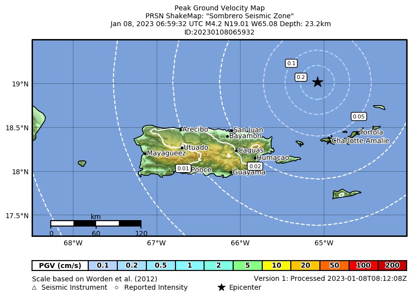 Peak Ground Velocity |
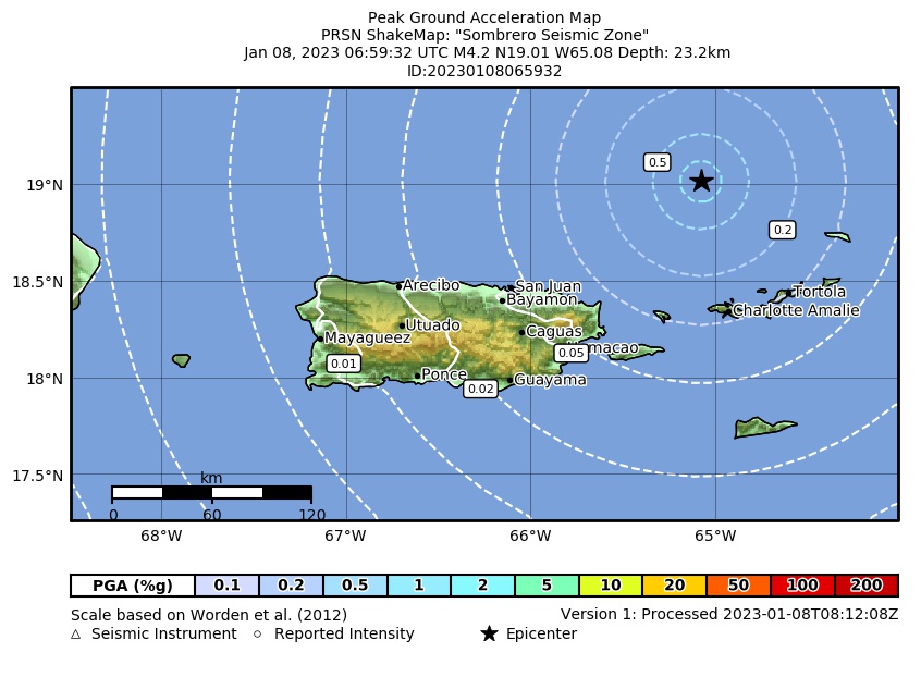 Peak Ground Acceleration |
 DYFI Map |
Google Map for this Event |