
This information is Issued for Puerto Rico and the Virgin Islands.For more information visit your corresponding Seismological Institution or theTsunami Warning Centers
| Event Details | |
|---|---|
| Estimated Maximum Intensity: | II in Tortola, BVI |
| Date: |
January 31, 2023 23:50:22 UTC January 31, 2023 19:50:22 Hora Local |
| Region: | Virgin Islands Platform |
| Distances: |
4.8 Km East of Road Town, Tortola,BVI 20.08 Km West-Southeast of Virgin Gorda,BVI 163.28 Km East of San Juan,PR |
| Magnitude: | 3.48 Md |
| Location: | Latitude: 18.4166 Longitude: -64.5783 |
| Depth: | 5 Km |
| Tsunami Warning Level: | No Warning, Advisory or Watch is in effect for Puerto Rico and the Virgin Islands |
| Issued Date & Time | 2023-01-31 20:29:24 |
| ID: | 20230131235025 |
Epicentral Map
| BULLETIN 2 Seismic Event/Tsunami |
|
|---|---|
| DATE: | January 31, 2023 |
| LOCAL TIME: | 19:50:22 |
| LATITUDE: | 18.4166 N |
| LONGITUDE: | 64.5783 W |
| LOCATION: |
4.8 Km East of Road Town, Tortola,BVI
163.3 Km East of San Juan,PR |
| DEPTH: | 5 Km |
| MAGNITUDE: | 3.48 Md |
| ESTIMATED MAXIMUM INTENSITY: | II in Tortola, BVI |
| TSUNAMI ALERT LEVEL: | No Warning, Advisory or Watch is in effect for Puerto Rico and the Virgin Islands |
| DATE & ISSUED TIME | 2023-01-31 20:29:29 |
|
The Puerto Rico Seismic Network (PRSN) received information that this
minor earthquake was reported as
felt in Tortola with a maximum
intensity of II (Modified Mercalli Scale, MM).
At the moment of generating this bulletin no damages has been reported and are not expected to occur Based on magnitude, location and historic records the earthquake was not sufficient to generate a destructive tsunami to Puerto Rico and Virgin Islands. |
|

|
|
Technical Information
YEAR MO DA  --ORIGIN--  --LAT N-  --LON W--  DEPTH   RMS   ERH   ERZ  XMAG  FMAG  PMAG  INT
2023-01-31  2350 22.84  18 25.00   64 34.70   5.00  0.66  3.96 31.61        3.48  3.48D II
                                                                                         SOURCE
NSTA NPHS  DMIN MODEL GAP ITR NFM NWR NWS NVR REMRKS-AVH  N.XMG-XMMAD-T   N.FMG-FMMAD-T  L F X
  21   21  40.6  PR1  290  14  10  12   6  21     Q- PPT   0.00  0.00      7.00  0.08 D

XMAG2-N.XMG2-XMMAD-T-S  FMAG2-N.FMG2-FMMAD-T-S  PREF.MAG-N.PMAG-PRMAD-T
                         3.48   7.00  0.08 Z        3.48   7.00  0.08 D

REGION= Virgin Islands Platform

STA NET COM CR DIST AZM  AN P/S WT   SEC (TOBS -TCAL -DLY  =RES)  WT   SR  INFO  CAL DUR-W-FMAG-T -AMP-U-PER-W-XMAG-T
STVI PR HHZ  A 40.6 260  57 IPU    30.12  7.28  7.47 0.00 -0.19  2.24     0.459 0.55  88   3.48 Z
STVI PR HH1  A 40.6 260  57 ES  1  35.25 12.41 13.30 0.00 -0.89* 1.12S    0.377
CUPR PR HHZ  A 75.4 261  50 EP+ 1  35.70 12.86 12.77 0.00  0.09  1.12     0.142 0.55  77   3.40 Z
CUPR PR HH1  A 75.4 261  50 ES  1  44.83 21.99 22.73 0.00 -0.74* 1.12S    0.257
CDVI PR HHZ  A 76.1 196  50 IPU    35.34 12.50 12.88 0.00 -0.38  2.24     0.696
CDVI PR HH2  A 76.1 196  50 ES  1  46.47 23.63 22.93 0.00  0.70* 1.12S    0.631
MTP  PR HHZ  A108.9 252  44 EP+ 1  40.51 17.67 17.15 0.00  0.52* 1.12     0.125 0.55  85   3.53 Z
MTP  PR HH2  A108.9 252  44 ES  2  53.98 31.14 30.53 0.00  0.61* 0.45S    0.032
HUMP PR HHZ  A137.7 258  44 EP+ 1  45.46 22.62 20.79 0.00  1.83* 0.74     0.067 0.55  74   3.43 Z
HUMP PR HH1  A137.7 258  44 ES  1  61.13 38.29 37.01 0.00  1.28* 1.12S    0.177
GCPR PR HHZ  A159.5 266  44 EP+ 2  48.34 25.50 23.55 0.00  1.95* 0.18     0.005
GCPR PR HH2  A159.5 266  44 ES  2  66.20 43.36 41.92 0.00  1.44* 0.43S    0.025
ECPR PR HHZ  A188.9 267  44 EP+ 2  53.02 30.18 27.27 0.00  2.91* 0.00     0.000 0.55  67   3.40 Z
ECPR PR HH1  A188.9 267  44 ES  2  73.61 50.77 48.54 0.00  2.23* 0.00S    0.000
CELP PR HHZ  A215.0 261  44 EP+ 2  56.31 33.47 30.57 0.00  2.90* 0.00     0.000 0.55  90   3.70 Z
CELP PR HH1  A215.0 261  44 ES  1  81.52 58.68 54.41 0.00  4.27* 0.00S    0.000
AOPR PR HHZ  A230.1 269  44 EP+ 3  60.08 37.24 32.48 0.00  4.76* 0.00     0.000 0.55  81   3.62 Z
AOPR PR HH2  A230.1 269  44 ES  3  84.35 61.51 57.81 0.00  3.70* 0.00S    0.000
GBPR PR HHZ  A248.3 260  44 EP+ 3  62.41 39.57 34.79 0.00  4.78* 0.00     0.000
GBPR PR HH1  A248.3 260  44 ES  3  90.62 67.78 61.93 0.00  5.85* 0.00S    0.000
CRPR PR HH1  A271.7 261  44 ES  3  96.87 74.03 67.18 0.00  6.85* 0.00S    0.000
Event Maps
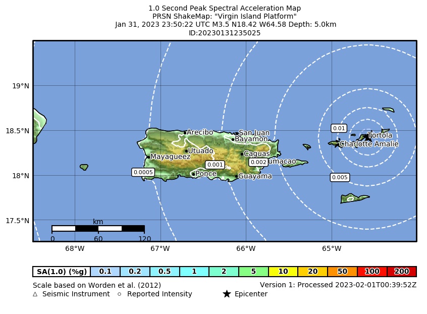 Spectral Acceleration |
 Intensity Map |
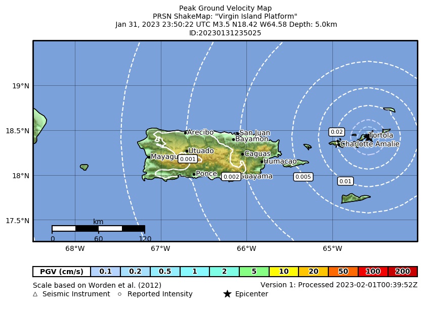 Peak Ground Velocity |
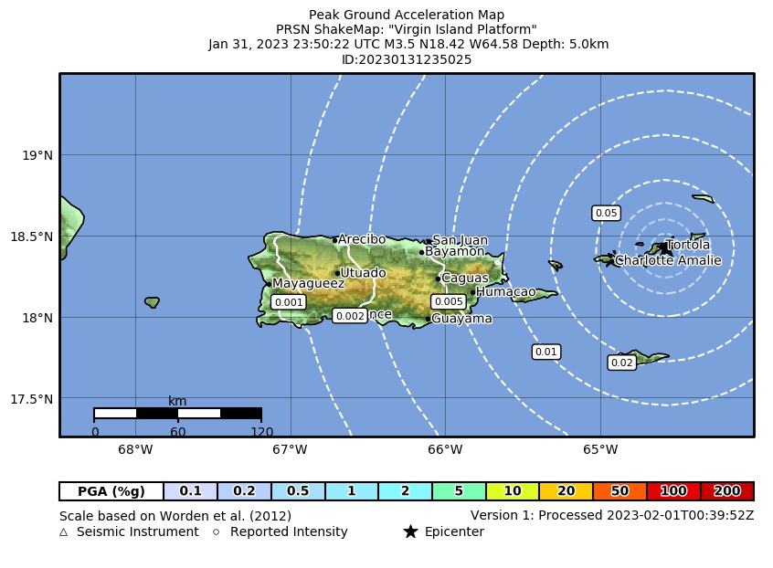 Peak Ground Acceleration |
 DYFI Map |
Google Map for this Event |