
This information is Issued for Puerto Rico and the Virgin Islands.For more information visit your corresponding Seismological Institution or theTsunami Warning Centers
| Event Details | |
|---|---|
| Estimated Maximum Intensity: | II in Añasco, PR |
| Date: |
March 04, 2023 05:21:53 UTC March 04, 2023 01:21:53 Hora Local |
| Region: | Eastern Dominican Republic |
| Distances: |
40.01 Km East of Punta Cana,DR 53.49 Km East-Northeast of Higüey,DR 135.89 Km West-Northwest of Mayagüez,PR |
| Magnitude: | 4.40 Md |
| Location: | Latitude: 18.7546 Longitude: -68.2101 |
| Depth: | 94 Km |
| Tsunami Warning Level: | No Warning, Advisory or Watch is in effect for Puerto Rico and the Virgin Islands |
| Issued Date & Time | 2023-03-04 02:33:15 |
| ID: | 20230304052151 |
Epicentral Map
| BULLETIN 2 Seismic Event/Tsunami |
|
|---|---|
| DATE: | March 04, 2023 |
| LOCAL TIME: | 01:21:53 |
| LATITUDE: | 18.7546 N |
| LONGITUDE: | 68.2101 W |
| LOCATION: |
40 Km East of Punta Cana,DR
135.9 Km West-Northwest of Mayagüez,PR |
| DEPTH: | 94 Km |
| MAGNITUDE: | 4.40 Md |
| ESTIMATED MAXIMUM INTENSITY: | II in Añasco, PR |
| TSUNAMI ALERT LEVEL: | No Warning, Advisory or Watch is in effect for Puerto Rico and the Virgin Islands |
| DATE & ISSUED TIME | 2023-03-04 02:33:25 |
|
The Puerto Rico Seismic Network (PRSN) received information that this
light earthquake was reported as
felt in Adjuntas and Añasco with a maximum
intensity of II (Modified Mercalli Scale, MM).
At the moment of generating this bulletin no damages has been reported and are not expected to occur Based on magnitude, location and historic records the earthquake was not sufficient to generate a destructive tsunami to Puerto Rico and Virgin Islands. |
|

|
|
Technical Information
YEAR MO DA  --ORIGIN--  --LAT N-  --LON W--  DEPTH   RMS   ERH   ERZ  XMAG  FMAG  PMAG  INT
2023-03-04  0521 53.31  18 45.28   68 12.61  94.95  0.45  2.98  2.31        4.40  4.40D II
                                                                                         SOURCE
NSTA NPHS  DMIN MODEL GAP ITR NFM NWR NWS NVR REMRKS-AVH  N.XMG-XMMAD-T   N.FMG-FMMAD-T  L F X
  47   47  32.1  PR1  158  12  23  17   6  39     Q  PPK   0.00  0.00     19.00  0.17 D

XMAG2-N.XMG2-XMMAD-T-S  FMAG2-N.FMG2-FMMAD-T-S  PREF.MAG-N.PMAG-PRMAD-T
                         4.40  19.00  0.17 Z        4.40  19.00  0.17 D

REGION= Eastern Dominican Republic

STA NET COM CR DIST AZM  AN P/S WT   SEC (TOBS -TCAL -DLY  =RES)  WT   SR  INFO  CAL DUR-W-FMAG-T -AMP-U-PER-W-XMAG-T
PCDR PR BHZ  A 32.1 215 160 IPD    66.34 13.03 13.51 0.00 -0.48  2.48     0.464 0.55 217   4.40 Z
PCDR PR BHN  A 32.1 215 160 ES  1  77.67 24.36 24.05 0.00  0.31  1.24S    0.607
IMPR PR HHZ  A 80.6 158 137 EP+ 1  70.96 17.65 16.72 0.00  0.93* 1.22     0.271 0.55 194   4.39 Z
SMDR PR BHZ  A118.8 301 126 IPU    73.80 20.49 20.33 0.00  0.16  2.46     0.703 0.00 225   3.71 Z
SMDR PR BHE  A118.8 301 126 ES  1  89.62 36.31 36.19 0.00  0.12  1.23S    0.444
AGPR PR HHZ  A120.3 105 125 EP+ 1  73.05 19.74 20.48 0.00 -0.74* 1.22     0.146 0.55 281   4.77 Z
AGPR PR HH2  A120.3 105 125 ES  1  89.83 36.52 36.45 0.00  0.07  1.22S    0.503
PRSN PR HHZ  A127.3 117 124 EP+ 1  75.25 21.94 21.21 0.00  0.73* 1.19     0.132 0.55 182   4.38 Z
CRPR PR HHZ  A142.8 125 121 EP- 1  76.09 22.78 22.86 0.00 -0.08  1.03     0.142 0.55 194   4.46 Z
MLPR PR HHZ  A150.8 125 119 EP- 1  76.86 23.55 23.73 0.00 -0.18  0.91     0.121 0.55 217   4.57 Z
AOPR PR HHZ  A160.2 106 118 EP+ 1  77.77 24.46 24.78 0.00 -0.32  0.76     0.070 0.55 158   4.29 Z
AOPR PR HH2  A160.2 106 118 ES  1  97.49 44.18 44.11 0.00  0.07  0.76S    0.151
GBPR PR HHZ  A165.0 121 117 EP+ 3  80.23 26.92 25.32 0.00  1.60* 0.00     0.000 0.58 149   4.22 Z
GBPR PR HH1  A165.0 121 117 ES  3 101.61 48.30 45.07 0.00  3.23* 0.00S    0.000
UUPR PR HHZ  A166.9 109 117 EP- 1  78.79 25.48 25.52 0.00 -0.04  0.65     0.051 0.55 186   4.45 Z
UUPR PR HH1  A166.9 109 117 ES  1  99.56 46.25 45.43 0.00  0.82* 0.65S    0.092
EMPR PR HHZ  A180.0  99 115 EP+ 1  79.71 26.40 27.02 0.00 -0.62* 0.42     0.027 0.55 140   4.20 Z
EMPR PR HH2  A180.0  99 115 ES  1 101.25 47.94 48.10 0.00 -0.16  0.42S    0.066
OBIP PR BHZ  A186.9 114 114 EP- 3  82.89 29.58 27.81 0.00  1.77* 0.00     0.000 0.87 194   4.31 Z
OBIP PR BHN  A186.9 114 114 ES  3 104.22 50.91 49.50 0.00  1.41* 0.00S    0.000
CELP PR HHZ  A188.0 113 114 EP- 3  82.45 29.14 27.94 0.00  1.20* 0.00     0.000 0.55 161   4.34 Z
CELP PR HH2  A188.0 113 114 ES  3 104.73 51.42 49.73 0.00  1.69* 0.00S    0.000
ECPR PR HHZ  A200.9 103 112 EP- 1  82.29 28.98 29.44 0.00 -0.46  0.13     0.002
SJG  IU BHZ  A229.0 107 110 EP- 1  86.39 33.08 32.75 0.00  0.33  0.00     0.000
SJG  IU BH1  A229.0 107 110 ES  3 113.25 59.94 58.29 0.00  1.65* 0.00S    0.000
GCPR PR HHZ  A229.9 102 109 EP- 1  85.48 32.17 32.86 0.00 -0.69* 0.00     0.000 0.55 152   4.33 Z
GCPR PR HH1  A229.9 102 109 ES  1 112.10 58.79 58.49 0.00  0.30  0.00S    0.000
IGPR PR HHZ  A238.9 111 109 EP- 1  88.12 34.81 33.93 0.00  0.88* 0.00     0.000 0.55 205   4.61 Z
IGPR PR HH2  A238.9 111 109 ES  3 116.07 62.76 60.40 0.00  2.36* 0.00S    0.000
HUMP PR HHZ  A258.5 104 107 EP- 1  88.87 35.56 36.29 0.00 -0.73* 0.00     0.000 0.55 261   4.86 Z
HUMP PR HH1  A258.5 104 107 ES  3 119.15 65.84 64.60 0.00  1.24* 0.00S    0.000
FAPR PR HHZ  A276.2 102 106 EP+ 1  91.50 38.19 38.43 0.00 -0.24  0.00     0.000
FAPR PR HH1  A276.2 102 106 ES  1 120.79 67.48 68.41 0.00 -0.93* 0.00S    0.000
MTP  PR HHZ  A290.1 104 105 EP- 1  92.89 39.58 40.12 0.00 -0.54* 0.00     0.000 0.55 204   4.67 Z
CUPR PR HHZ  A313.1  98 104 EP+ 1  94.14 40.83 42.93 0.00 -2.10* 0.00     0.000
STVI PR HHZ  A346.5  96 103 EP- 1  98.43 45.12 47.03 0.00 -1.91* 0.00     0.000 0.55 194   4.68 Z
STVI PR HH2  A346.5  96 103 ES  1 135.97 82.66 83.71 0.00 -1.05* 0.00S    0.000
SJVI PR HHZ  A366.2  96 102 EP+ 1 100.69 47.38 49.46 0.00 -2.08* 0.00     0.000 0.55 215   4.81 Z
SJVI PR HH2  A366.2  96 102 ES  1 140.29 86.98 88.04 0.00 -1.06* 0.00S    0.000
   8 UNWEIGHTED STATIONS NOT PRINTED.
Event Maps
 Spectral Acceleration |
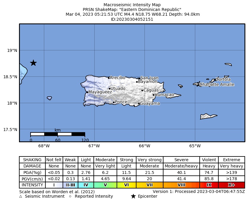 Intensity Map |
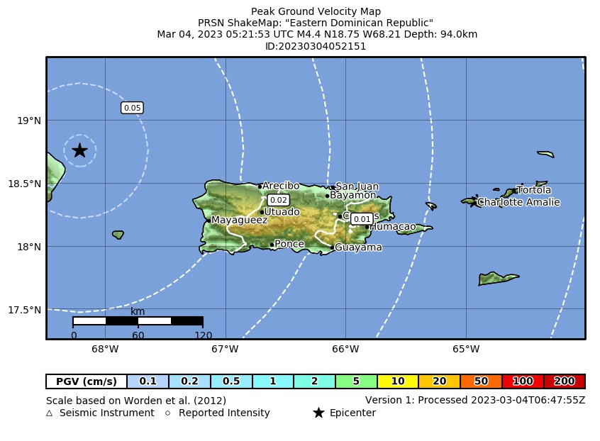 Peak Ground Velocity |
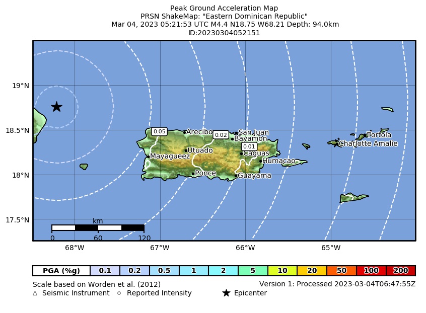 Peak Ground Acceleration |
 DYFI Map |
Google Map for this Event |