
This information is Issued for Puerto Rico and the Virgin Islands.For more information visit your corresponding Seismological Institution or theTsunami Warning Centers
| Event Details | |
|---|---|
| Estimated Maximum Intensity: | IV in Mayagüez, PR |
| Date: |
March 16, 2023 21:57:24 UTC March 16, 2023 17:57:24 Hora Local |
| Region: | West Region of Puerto Rico |
| Distances: |
4.08 Km East-Southeast of Hormigueros,PR 5.31 Km West-Northwest of San Germán,PR 8.95 Km South-Southeast of Mayagüez,PR |
| Magnitude: | 3.35 Md |
| Location: | Latitude: 18.128 Longitude: -67.083 |
| Depth: | 14 Km |
| Tsunami Warning Level: | No Warning, Advisory or Watch is in effect for Puerto Rico and the Virgin Islands |
| Issued Date & Time | 2023-03-16 18:21:06 |
| ID: | 20230316215723 |
Epicentral Map
| BULLETIN 2 Seismic Event/Tsunami |
|
|---|---|
| DATE: | March 16, 2023 |
| LOCAL TIME: | 17:57:24 |
| LATITUDE: | 18.128 N |
| LONGITUDE: | 67.083 W |
| LOCATION: |
4.1 Km East-Southeast of Hormigueros,PR
9 Km South-Southeast of Mayagüez,PR |
| DEPTH: | 14 Km |
| MAGNITUDE: | 3.35 Md |
| ESTIMATED MAXIMUM INTENSITY: | IV in Mayagüez, PR |
| TSUNAMI ALERT LEVEL: | No Warning, Advisory or Watch is in effect for Puerto Rico and the Virgin Islands |
| DATE & ISSUED TIME | 2023-03-16 18:21:11 |
|
The Puerto Rico Seismic Network (PRSN) received information that this
minor earthquake was reported as
felt in the Western region of Puerto Rico and the Southern region of Puerto Rico with a maximum
intensity of IV (Modified Mercalli Scale, MM).
At the moment of generating this bulletin no damages has been reported and are not expected to occur Based on magnitude, location and historic records the earthquake was not sufficient to generate a destructive tsunami to Puerto Rico and Virgin Islands. |
|

|
|
Technical Information
YEAR MO DA  --ORIGIN--  --LAT N-  --LON W--  DEPTH   RMS   ERH   ERZ  XMAG  FMAG  PMAG  INT
2023-03-16  2157 24.31  18  7.68   67  4.98  14.66  0.22  0.42  0.87        3.35  3.35D IV
                                                                                         SOURCE
NSTA NPHS  DMIN MODEL GAP ITR NFM NWR NWS NVR REMRKS-AVH  N.XMG-XMMAD-T   N.FMG-FMMAD-T  L F X
  39   39   5.3  PR1  114  19  19  23  11  39     Q  PPT   0.00  0.00     18.00  0.09 D

XMAG2-N.XMG2-XMMAD-T-S  FMAG2-N.FMG2-FMMAD-T-S  PREF.MAG-N.PMAG-PRMAD-T
                         3.35  18.00  0.09 Z        3.35  18.00  0.09 D

REGION= Western Puerto Rico

STA NET COM CR DIST AZM  AN P/S WT   SEC (TOBS -TCAL -DLY  =RES)  WT   SR  INFO  CAL DUR-W-FMAG-T -AMP-U-PER-W-XMAG-T
LSP  PR HHZ  A  5.3 357 155 EP+ 1  27.21  2.90  2.73 0.00  0.17  1.01     0.123 0.58 103   3.39 Z
LSP  PR HH1  A  5.3 357 155 ES  1  29.62  5.31  4.86 0.00  0.45  1.01S    0.505
PRSN PR HHZ  A 11.9 327 130 EP+ 1  27.57  3.26  3.29 0.00 -0.03  1.01     0.087
PRSN PR HH2  A 11.9 327 130 ES  1  29.96  5.65  5.86 0.00 -0.21  1.01S    0.270
CRPR PR HHZ  A 13.7 192 125 EP- 1  27.76  3.45  3.50 0.00 -0.05  1.01     0.143 0.55  77   3.20 Z
CRPR PR HH2  A 13.7 192 125 ES  1  30.17  5.86  6.23 0.00 -0.37  1.01S    0.293
MLPR PR HHZ  A 18.0 166 113 EP+ 1  28.23  3.92  4.02 0.00 -0.10  1.01     0.131 0.55  77   3.23 Z
MLPR PR HH2  A 18.0 166 113 ES  1  31.18  6.87  7.16 0.00 -0.29  1.01S    0.247
GBPR PR HHZ  A 27.4 128  96 EP+ 1  29.82  5.51  5.30 0.00  0.21  1.01     0.104 0.58  77   3.26 Z
GBPR PR HH2  A 27.4 128  96 ES  1  34.40 10.09  9.43 0.00  0.66* 0.46S    0.037
AGPR PR HHZ  A 37.7 356  92 IPU    31.12  6.81  6.75 0.00  0.06  2.03     0.362 0.55  71   3.27 Z
AGPR PR HH1  A 37.7 356  92 ES  1  36.05 11.74 12.01 0.00 -0.27  1.01S    0.171
UUPR PR HHZ  A 40.8  70  92 EP- 1  31.52  7.21  7.19 0.00  0.02  1.01     0.071 0.55  86   3.46 Z
UUPR PR HH1  A 40.8  70  92 ES  1  36.66 12.35 12.80 0.00 -0.45  1.01S    0.182
AOPR PR HHZ  A 42.4  55  91 EP+ 1  31.83  7.52  7.41 0.00  0.11  1.01     0.071 0.55 104   3.64 Z
AOPR PR HH2  A 42.4  55  91 ES  1  37.16 12.85 13.19 0.00 -0.34  1.01S    0.189
IDE  PR EHZ  A 49.6 306  91 EP+ 1  32.85  8.54  8.42 0.00  0.12  1.01     0.187 0.58  69   3.25 Z
IDE  PR EHE  A 49.6 306  91 ES  1  39.31 15.00 14.99 0.00  0.01  1.01S    0.316
OBIP PR BHZ  A 51.4 100  91 EP- 1  33.12  8.81  8.67 0.00  0.14  1.01     0.083 0.87  83   3.24 Z
OBIP PR BHN  A 51.4 100  91 ES  1  39.93 15.62 15.43 0.00  0.19  1.01S    0.164
CELP PR HHZ  A 53.7  96  91 EP- 1  33.44  9.13  9.00 0.00  0.13  1.01     0.081 0.55  73   3.33 Z
CELP PR HH1  A 53.7  96  91 ES  1  40.15 15.84 16.02 0.00 -0.18  1.01S    0.164
EMPR PR HHZ  A 70.1  56  63 EP- 1  36.47 12.16 11.28 0.00  0.88* 0.00     0.000 0.55  69   3.29 Z
EMPR PR HH1  A 70.1  56  63 ES  1  45.36 21.05 20.08 0.00  0.97* 0.00S    0.000
ECPR PR HHZ  A 79.1  74  63 EP+ 1  37.38 13.07 12.41 0.00  0.66* 0.22     0.007 0.55  78   3.42 Z
ECPR PR HH2  A 79.1  74  63 ES  1  47.91 23.60 22.09 0.00  1.51* 0.00S    0.000
SJG  IU BHZ  A 98.8  90  63 EP+ 1  40.08 15.77 14.90 0.00  0.87* 0.00     0.000 0.73  83   3.37 Z
SJG  IU BH1  A 98.8  90  63 ES  1  51.90 27.59 26.52 0.00  1.07* 0.00S    0.000
IGPR PR HHZ  A104.9  99  63 EP+ 1  41.47 17.16 15.68 0.00  1.48* 0.00     0.000 0.55  77   3.43 Z
IGPR PR HH1  A104.9  99  63 ES  1  53.93 29.62 27.91 0.00  1.71* 0.00S    0.000
GCPR PR HHZ  A107.6  79  63 EP+ 1  41.38 17.07 16.02 0.00  1.05* 0.00     0.000 0.55  74   3.40 Z
GCPR PR HH2  A107.6  79  63 ES  1  54.35 30.04 28.52 0.00  1.52* 0.00S    0.000
PCDR PR BHN  A143.7 288  63 ES  1  62.00 37.69 36.65 0.00  1.04* 0.00S    0.000
FAPR PR HHZ  A151.2  86  63 EP+ 2  47.87 23.56 21.55 0.00  2.01* 0.00     0.000 0.55  62   3.29 Z
FAPR PR HH1  A151.2  86  63 ES  2  64.54 40.23 38.36 0.00  1.87* 0.00S    0.000
CUPR PR HHZ  A191.5  83  63 EP- 1  53.27 28.96 26.64 0.00  2.32* 0.00     0.000 0.55  96   3.73 Z
CUPR PR HH1  A191.5  83  63 ES  2  75.40 51.09 47.42 0.00  3.67* 0.00S    0.000
SJVI PR HHZ  A245.5  84  63 EP+ 1  60.51 36.20 33.48 0.00  2.72* 0.00     0.000 0.55 104   3.86 Z
SJVI PR HH1  A245.5  84  63 ES  1  87.43 63.12 59.59 0.00  3.53* 0.00S    0.000
Event Maps
 Spectral Acceleration |
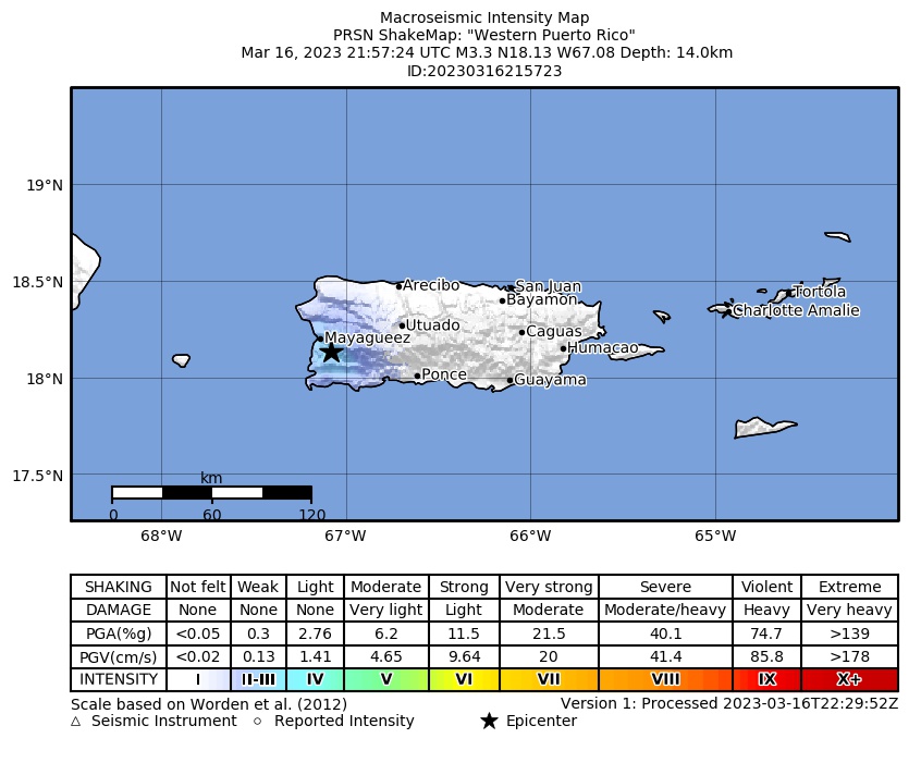 Intensity Map |
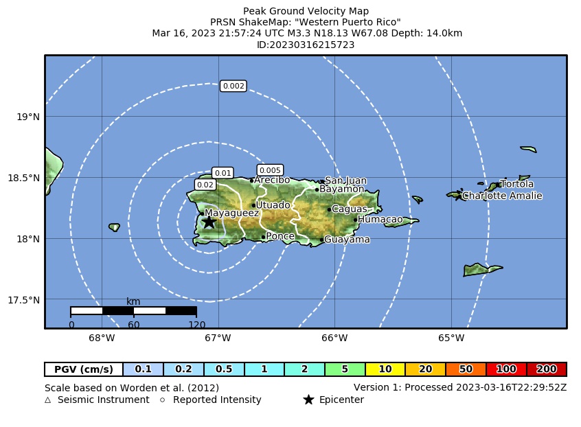 Peak Ground Velocity |
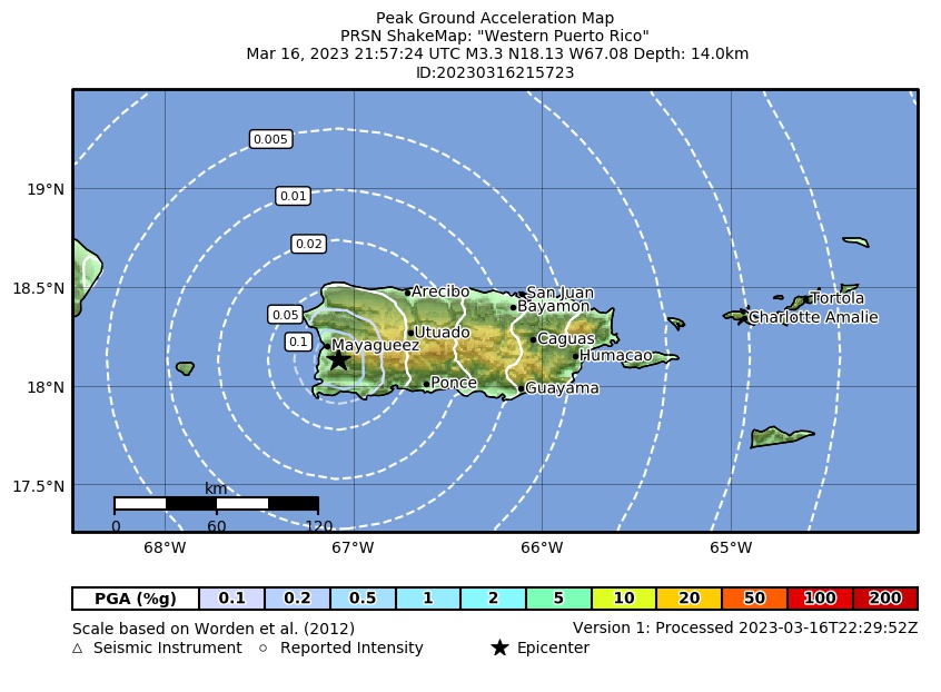 Peak Ground Acceleration |
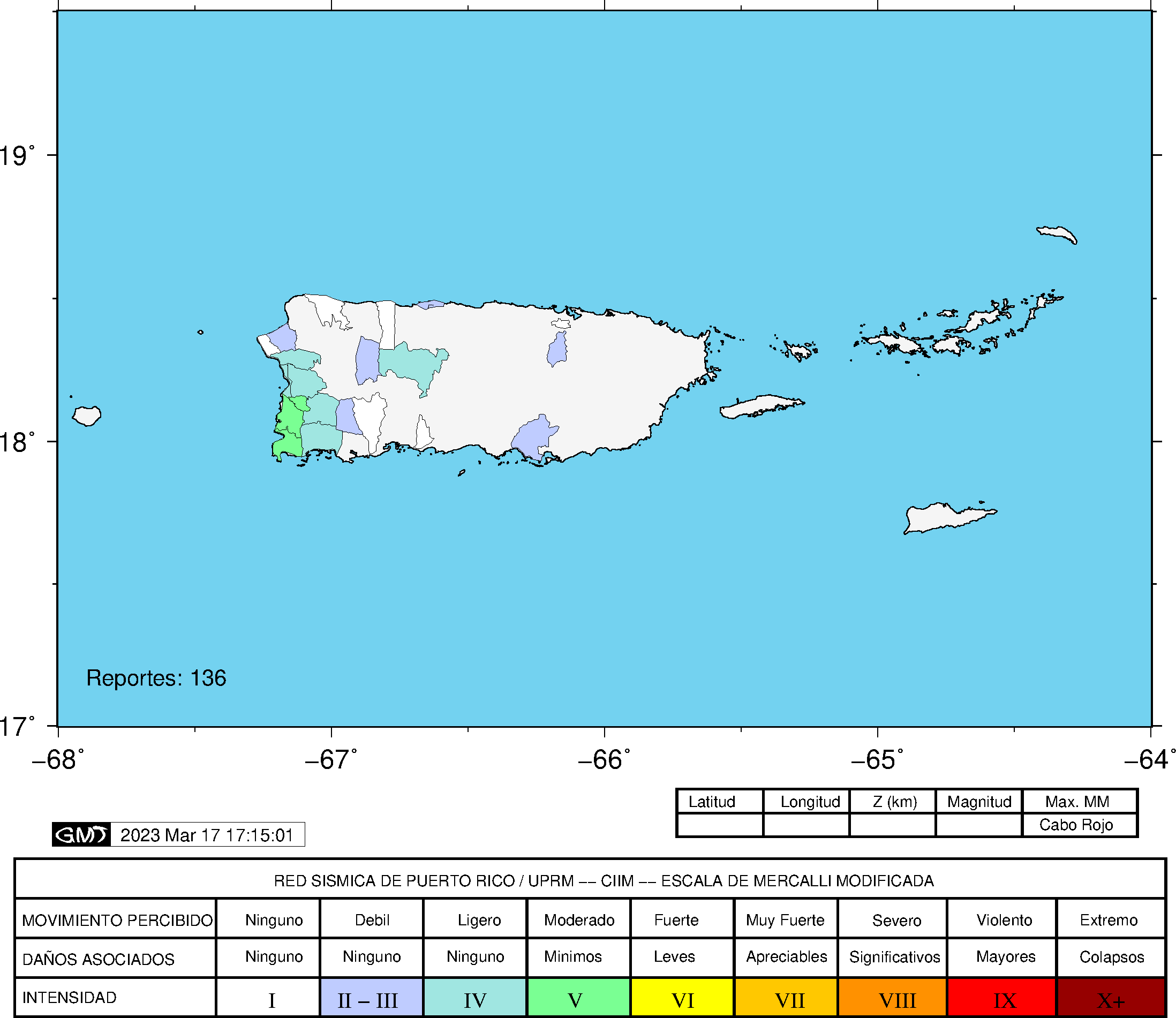 DYFI Map |
Google Map for this Event |