
This information is Issued for Puerto Rico and the Virgin Islands.For more information visit your corresponding Seismological Institution or theTsunami Warning Centers
| Event Details | |
|---|---|
| Estimated Maximum Intensity: | II in San Germán, PR |
| Date: |
March 17, 2023 17:01:58 UTC March 17, 2023 13:01:58 Hora Local |
| Region: | Southwest Region of Puerto Rico |
| Distances: |
2.42 Km East-Southeast of Lajas,PR 12 Km West of Guánica,PR 23.93 Km South-Southeast of Mayagüez,PR |
| Magnitude: | 2.68 Md |
| Location: | Latitude: 18.0056 Longitude: -67.0205 |
| Depth: | 7 Km |
| Tsunami Warning Level: | No Warning, Advisory or Watch is in effect for Puerto Rico and the Virgin Islands |
| Issued Date & Time | 2023-03-17 13:58:50 |
| ID: | 20230317170158 |
Epicentral Map
| BULLETIN 1 Seismic Event/Tsunami |
|
|---|---|
| DATE: | March 17, 2023 |
| LOCAL TIME: | 13:01:58 |
| LATITUDE: | 18.0056 N |
| LONGITUDE: | 67.0205 W |
| LOCATION: |
2.4 Km East-Southeast of Lajas,PR
23.9 Km South-Southeast of Mayagüez,PR |
| DEPTH: | 7 Km |
| MAGNITUDE: | 2.68 Md |
| ESTIMATED MAXIMUM INTENSITY: | II in San Germán, PR |
| TSUNAMI ALERT LEVEL: | No Warning, Advisory or Watch is in effect for Puerto Rico and the Virgin Islands |
| DATE & ISSUED TIME | 2023-03-17 13:58:56 |
|
The Puerto Rico Seismic Network (PRSN) received information that this
micro earthquake was reported as
felt in Lajas and San Germán with a maximum
intensity of II (Modified Mercalli Scale, MM).
At the moment of generating this bulletin no damages has been reported and are not expected to occur Based on magnitude, location and historic records the earthquake was not sufficient to generate a destructive tsunami to Puerto Rico and Virgin Islands. |
|

|
|
Technical Information
YEAR MO DA  --ORIGIN--  --LAT N-  --LON W--  DEPTH   RMS   ERH   ERZ  XMAG  FMAG  PMAG  INT
2023-03-17  1701 58.77  18  0.34   67  1.23   7.97  0.28  0.62  1.66        2.68  2.68D    I
                                                                                         SOURCE
NSTA NPHS  DMIN MODEL GAP ITR NFM NWR NWS NVR REMRKS-AVH  N.XMG-XMMAD-T   N.FMG-FMMAD-T  L F X
  11   19   4.7  PR1  110      11  19  11  19     Q  A2               N       6 0.269 D  Y Y N

XMAG2-N.XMG2-XMMAD-T-S  FMAG2-N.FMG2-FMMAD-T-S  PREF.MAG-N.PMAG-PRMAD-T
                                                    2.68      6 0.269 D

Event_ID= 71400663
Region= Southwest Region of Puerto Rico
Comment= Revision: 2023-03-17T17:48:49.45

 STA NET COM LOC CR DIST AZM  AN P/S WT  SEC  (TOBS -TCAL -DLY  =RES) WT  SR INFO  CAL DUR-W-FMAG-T -AMP-U-PER-W-XMAG-T
 MLPR PR HHZ 00   A  4.7 211 140 EPD 1  00.37  1.60  1.81    0 -0.21 0.10  J   mr 0.55  33 1 2.38 Z
 ISPR PR HN1 00   A  9.2 341 111 ES? 1  03.14  4.37  4.24    0  0.13 0.10  J   mr
 SNG1 PR HNZ --   A  9.6 353 107 EPU 1  01.56  2.79  2.45    0  0.34 0.10  J   mr
 SNG1 PR HNN --   A  9.6 353 107 ES? 1  02.81  4.04  4.36    0 -0.32 0.10  J   mr
 UUPR PR HHZ 00   A 41.4  49  90 EPU 1  06.06  7.29  7.39    0  -0.1 0.10  J   mr 0.55  71 0 3.29 Z
 AOPR PR HHZ 00   A 46.6  36  90 EPD 1  07.44  8.67  8.19    0  0.48 0.00  J   mr 0.55  47 1 2.92 Z
 AGPR PR HHZ 00   A 51.4 349  90 EPD 1  08.02  9.25  8.94    0  0.31 0.10  J   mr 0.55  38 0 2.73 Z
 AGPR PR HH1 00   A 51.4 349  90 ES? 1  14.52 15.75 15.91    0 -0.16 0.10  J   mr
 MLPR PR HH1 00   A  4.7 211 140 ES? 1  01.90  3.13  3.22    0 -0.09 0.10  J   mr
 ISPR PR HNZ 00   A  9.2 341 111 EPU 1  01.33  2.56  2.38    0  0.18 0.10  J   mr
 CRPR PR HHZ 00   A  9.3 270 109 EPD 1  01.07  2.30  2.40    0  -0.1 0.10  J   mr 0.55  48 1 2.75 Z
 CRPR PR HH1 00   A  9.3 270 109 ES? 1  02.91  4.14  4.27    0 -0.13 0.10  J   mr
 GBPR PR HHZ 00   A 15.2 102  90 IPD 0  02.31  3.54  3.30    0  0.24 0.20  J   mr 0.87  41 1 2.62 Z
 GBPR PR HH1 00   A 15.2 102  90 ES? 1  04.49  5.72  5.87    0 -0.15 0.10  J   mr
 PRSN PR HHZ 00   A 26.5 330  90 EPD 1  03.58  4.81  5.07    0 -0.26 0.10  J   mr 0.55  72 0 3.23 Z
 PRSN PR HH1 00   A 26.5 330  90 ES? 1  07.21  8.44  9.02    0 -0.58 0.00  J   mr
 UUPR PR HH1 00   A 41.4  49  90 ES? 1  11.13 12.36 13.15    0 -0.79 0.00  J   mr
 OBIP PR BHZ --   A 43.5  84  90 EPD 1  06.88  8.11  7.72    0  0.39 0.10  J   mr 0.87  31 1 2.34 Z
 OBIP PR BHN --   A 43.5  84  90 ES? 1  12.03 13.26 13.74    0 -0.48 0.10  J   mr
 AOPR PR HH1 00   A 46.6  36  90 ES? 1  12.52 13.75 14.58    0 -0.83 0.00  J   mr
 CELP PR HHZ 00   A 46.8  80  90 EPD 1  07.31  8.54  8.23    0  0.31 0.10  J   mr 0.55  50 1 2.98 Z
 CELP PR HH1 00   A 46.8  80  90 ES? 1  12.80 14.03 14.65    0 -0.62 0.10  J   mr
Event Maps
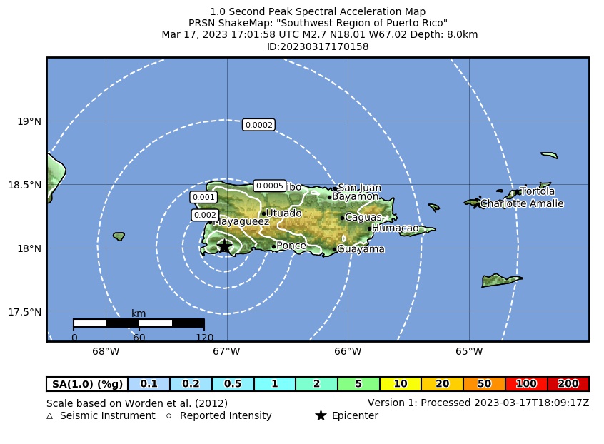 Spectral Acceleration |
 Intensity Map |
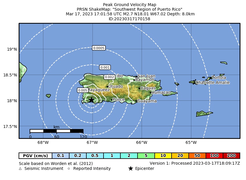 Peak Ground Velocity |
 Peak Ground Acceleration |
 DYFI Map |
Google Map for this Event |