
This information is Issued for Puerto Rico and the Virgin Islands.For more information visit your corresponding Seismological Institution or theTsunami Warning Centers
| Event Details | |
|---|---|
| Estimated Maximum Intensity: | III in Utuado, PR |
| Date: |
March 19, 2023 01:01:27 UTC March 18, 2023 21:01:27 Hora Local |
| Region: | 19° N Fault Zone |
| Distances: |
77.77 Km North-Northwest of Manati,PR 77.77 Km North of Arecibo,PR 77.77 Km North of Arecibo,PR |
| Magnitude: | 3.18 Md |
| Location: | Latitude: 19.1123 Longitude: -66.6403 |
| Depth: | 24 Km |
| Tsunami Warning Level: | No Warning, Advisory or Watch is in effect for Puerto Rico and the Virgin Islands |
| Issued Date & Time | 2023-03-20 17:51:09 |
| ID: | 20230319010127 |
Epicentral Map
| BULLETIN 1 Seismic Event/Tsunami |
|
|---|---|
| DATE: | March 18, 2023 |
| LOCAL TIME: | 21:01:27 |
| LATITUDE: | 19.1123 N |
| LONGITUDE: | 66.6403 W |
| LOCATION: |
77.8 Km North-Northwest of Manati,PR
77.8 Km North of Arecibo,PR |
| DEPTH: | 24 Km |
| MAGNITUDE: | 3.18 Md |
| ESTIMATED MAXIMUM INTENSITY: | III in Utuado, PR |
| TSUNAMI ALERT LEVEL: | No Warning, Advisory or Watch is in effect for Puerto Rico and the Virgin Islands |
| DATE & ISSUED TIME | 2023-03-20 15:32:15 |
|
The Puerto Rico Seismic Network (PRSN) received information that this
minor earthquake was reported as
felt in Utuado with a maximum
intensity of III (Modified Mercalli Scale, MM).
At the moment of generating this bulletin no damages has been reported and are not expected to occur Based on magnitude, location and historic records the earthquake was not sufficient to generate a destructive tsunami to Puerto Rico and Virgin Islands. |
|

|
|
Technical Information
YEAR MO DA  --ORIGIN--  --LAT N-  --LON W--  DEPTH   RMS   ERH   ERZ  XMAG  FMAG  PMAG  INT
2023-03-19  0101 27.47  19  6.74   66 38.42  24.82  0.25  1.39 18.10        3.18  3.18D III
                                                                                         SOURCE
NSTA NPHS  DMIN MODEL GAP ITR NFM NWR NWS NVR REMRKS-AVH  N.XMG-XMMAD-T   N.FMG-FMMAD-T  L F X
  17   17  85.6  PR1  301  10   8  17   9  17     Q- PPT   0.00  0.00      6.00  0.02 D

XMAG2-N.XMG2-XMMAD-T-S  FMAG2-N.FMG2-FMMAD-T-S  PREF.MAG-N.PMAG-PRMAD-T
                         3.18   6.00  0.02 Z        3.18   6.00  0.02 D

REGION= 19 N Fault Zone

STA NET COM CR DIST AZM  AN P/S WT   SEC (TOBS -TCAL -DLY  =RES)  WT   SR  INFO  CAL DUR-W-FMAG-T -AMP-U-PER-W-XMAG-T
AOPR PR HHZ  A 85.6 189  94 EP+ 1  40.17 12.70 12.93 0.00 -0.23  1.04     0.272 0.55  61   3.20 Z
AOPR PR HH2  A 85.6 189  94 ES  1  50.74 23.27 23.02 0.00  0.25  1.04S    0.497
ECPR PR HHZ  A 92.6 161  94 EP+ 1  41.33 13.86 13.81 0.00  0.05  1.04     0.179 0.55  64   3.25 Z
ECPR PR HH1  A 92.6 161  94 ES  1  52.09 24.62 24.58 0.00  0.04  1.04S    0.288
UUPR PR HH1  A 95.5 186  94 ES  1  52.53 25.06 25.24 0.00 -0.18  1.04S    0.187
GCPR PR HHZ  A106.5 146  93 EP+ 1  43.24 15.77 15.58 0.00  0.19  1.04     0.260
GCPR PR HH1  A106.5 146  93 ES  1  54.97 27.50 27.73 0.00 -0.23  1.04S    0.433
LSP  PR HHZ  A113.8 205  93 EP+ 2  43.81 16.34 16.50 0.00 -0.16  0.41     0.035 0.58  52   3.06 Z
LSP  PR HH1  A113.8 205  93 ES  1  56.40 28.93 29.37 0.00 -0.44  1.04S    0.222
CELP PR HHZ  A115.0 176  93 EP+ 1  43.97 16.50 16.65 0.00 -0.15  1.04     0.139 0.55  57   3.17 Z
CELP PR HH1  A115.0 176  93 ES  1  56.93 29.46 29.64 0.00 -0.18  1.04S    0.272
GBPR PR HHZ  A128.4 192  92 EP+ 1  45.81 18.34 18.34 0.00  0.00  1.04     0.157 0.58  57   3.16 Z
GBPR PR HH1  A128.4 192  92 ES  1  60.54 33.07 32.65 0.00  0.42  1.04S    0.246
CRPR PR HHZ  A132.1 203  92 EP+ 1  45.98 18.51 18.81 0.00 -0.30  1.04     0.194 0.55  57   3.19 Z
CRPR PR HH2  A132.1 203  92 ES  1  60.84 33.37 33.48 0.00 -0.11  1.04S    0.206
MLPR PR HHZ  A133.5 199  92 EP+ 1  46.87 19.40 18.98 0.00  0.42  1.04     0.178
MLPR PR HH2  A133.5 199  92 ES  1  61.41 33.94 33.78 0.00  0.16  1.04S    0.226
Event Maps
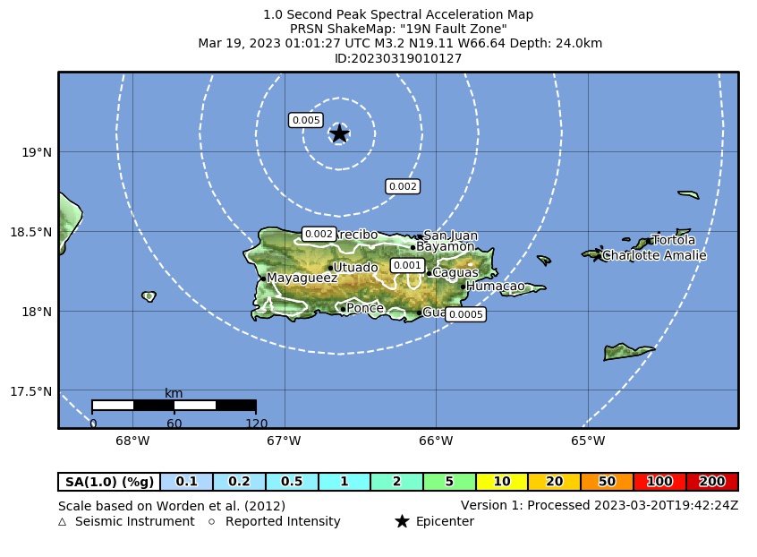 Spectral Acceleration |
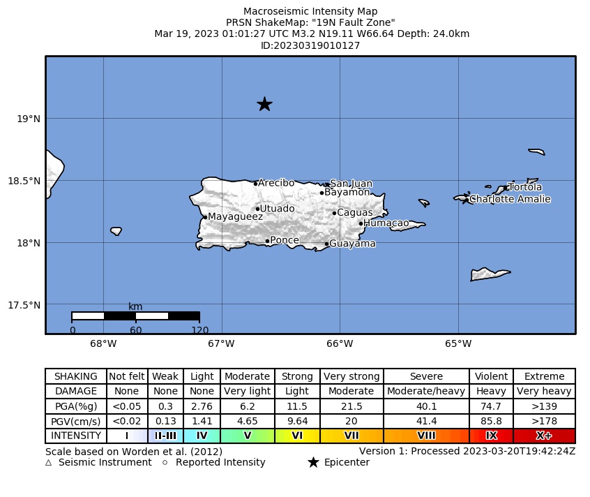 Intensity Map |
 Peak Ground Velocity |
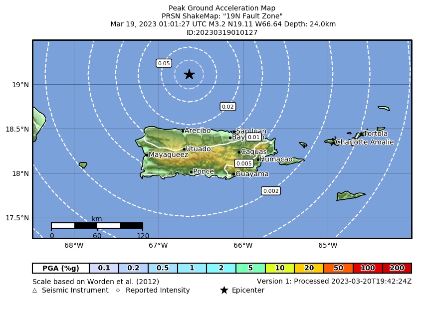 Peak Ground Acceleration |
 DYFI Map |
Google Map for this Event |