
This information is Issued for Puerto Rico and the Virgin Islands.For more information visit your corresponding Seismological Institution or theTsunami Warning Centers
| Event Details | |
|---|---|
| Estimated Maximum Intensity: | IV in Aguada, PR |
| Date: |
May 11, 2023 02:38:46 UTC May 10, 2023 22:38:46 Hora Local |
| Region: | Septentrional Fault Zone |
| Distances: |
84.97 Km North-Northwest of Desecheo,PR 98.04 Km Northwest of Aguadilla,PR 121.4 Km Northwest of Mayagüez,PR |
| Magnitude: | 4.30 Md |
| Location: | Latitude: 19.105 Longitude: -67.7443 |
| Depth: | 47 Km |
| Tsunami Warning Level: | No Warning, Advisory or Watch is in effect for Puerto Rico and the Virgin Islands |
| Issued Date & Time | 2023-05-10 23:42:30 |
| ID: | 20230511023847 |
Epicentral Map
| BULLETIN 2 Seismic Event/Tsunami |
|
|---|---|
| DATE: | May 10, 2023 |
| LOCAL TIME: | 22:38:46 |
| LATITUDE: | 19.105 N |
| LONGITUDE: | 67.7443 W |
| LOCATION: |
85 Km North-Northwest of Desecheo,PR
121.4 Km Northwest of Mayagüez,PR |
| DEPTH: | 47 Km |
| MAGNITUDE: | 4.30 Md |
| ESTIMATED MAXIMUM INTENSITY: | IV in Aguada, PR |
| TSUNAMI ALERT LEVEL: | No Warning, Advisory or Watch is in effect for Puerto Rico and the Virgin Islands |
| DATE & ISSUED TIME | 2023-05-10 23:42:41 |
|
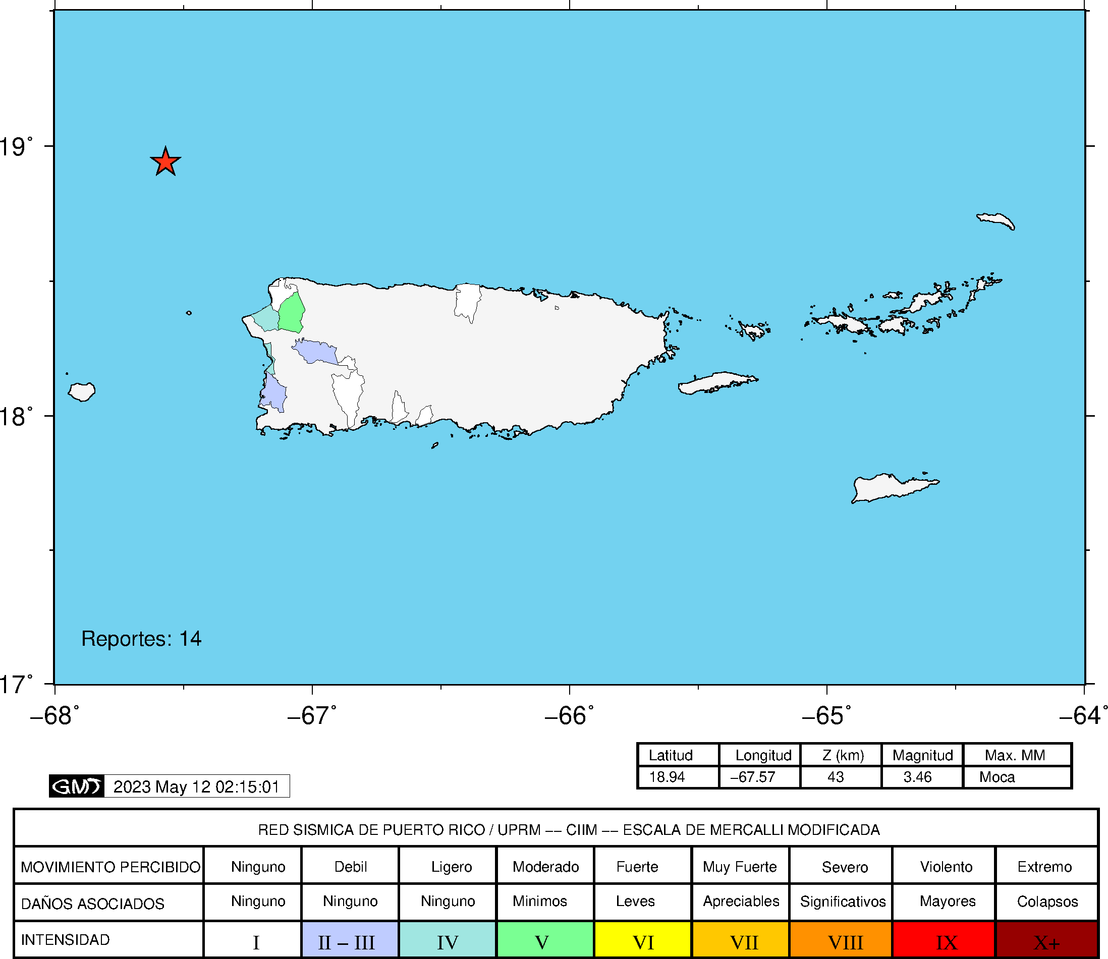
The Puerto Rico Seismic Network (PRSN) received information that this
light earthquake was reported as
felt in the Northern region of Puerto Rico and the Western region of Puerto Rico with a maximum
intensity of IV (Modified Mercalli Scale, MM).
At the moment of generating this bulletin no damages has been reported and are not expected to occur Based on magnitude, location and historic records the earthquake was not sufficient to generate a destructive tsunami to Puerto Rico and Virgin Islands. |
|

|
|
Technical Information
YEAR MO DA  --ORIGIN--  --LAT N-  --LON W--  DEPTH   RMS   ERH   ERZ  XMAG  FMAG  PMAG  INT
2023-05-11  0238 46.64  19  6.30   67 44.66  47.71  0.70  3.96 13.49        4.30  4.30D IV
                                                                                         SOURCE
NSTA NPHS  DMIN MODEL GAP ITR NFM NWR NWS NVR REMRKS-AVH  N.XMG-XMMAD-T   N.FMG-FMMAD-T  L F X
  36   36  84.9  PR1  251  14  17  28  11  31     Q  PPK   0.00  0.00      8.00  0.15 D

XMAG2-N.XMG2-XMMAD-T-S  FMAG2-N.FMG2-FMMAD-T-S  PREF.MAG-N.PMAG-PRMAD-T
                         4.30   8.00  0.15 Z        4.30   8.00  0.15 D

REGION= Septentrional Fault Zone

STA NET COM CR DIST AZM  AN P/S WT   SEC (TOBS -TCAL -DLY  =RES)  WT   SR  INFO  CAL DUR-W-FMAG-T -AMP-U-PER-W-XMAG-T
IDE  PR EHZ  A 84.9 159 113 EP- 1  58.37 11.73 13.58 0.00 -1.85* 0.92     0.070 0.58 155   4.07 Z
IDE  PR EHE  A 84.9 159 113 ES  1  67.05 20.41 24.17 0.00 -3.76* 0.00S    0.000
PCDR PR BHZ  A 93.7 226 111 EP- 1  61.96 15.32 14.61 0.00  0.71* 1.07     0.252
PCDR PR BHE  A 93.7 226 111 ES  1  73.80 27.16 26.01 0.00  1.15* 1.07S    0.571
AGPR PR HHZ  A 97.1 136 110 EP+ 1  60.34 13.70 15.02 0.00 -1.32* 1.07     0.121 0.55 182   4.25 Z
AGPR PR HH2  A 97.1 136 110 ES  1  71.04 24.40 26.74 0.00 -2.34* 0.07S    0.002
IMPR PR HHZ  A115.5 190 106 EP- 1  63.53 16.89 17.22 0.00 -0.33  1.07     0.151
IMPR PR HH2  A115.5 190 106 ES  1  76.15 29.51 30.65 0.00 -1.14* 1.07S    0.358
PRSN PR HHZ  A116.8 147 106 EP- 1  63.55 16.91 17.38 0.00 -0.47  1.07     0.042
LSP  PR HHZ  A124.1 145 105 EP- 1  64.67 18.03 18.27 0.00 -0.24  1.07     0.045
LSP  PR HH2  A124.1 145 105 ES  1  79.41 32.77 32.52 0.00  0.25  1.07S    0.155
AOPR PR HHZ  A134.0 128 104 EP+ 1  65.35 18.71 19.48 0.00 -0.77* 1.07     0.073 0.55 204   4.40 Z
AOPR PR HH2  A134.0 128 104 ES  1  80.86 34.22 34.67 0.00 -0.45  1.07S    0.202
CRPR PR HHZ  A138.8 151 103 EP+ 1  65.95 19.31 20.07 0.00 -0.76* 1.07     0.079 0.55 166   4.22 Z
CRPR PR HH2  A138.8 151 103 ES  3  84.28 37.64 35.72 0.00  1.92* 0.16S    0.004
UUPR PR HHZ  A143.4 130 103 EP- 1  67.02 20.38 20.64 0.00 -0.26  1.07     0.064
UUPR PR HH2  A143.4 130 103 ES  1  82.93 36.29 36.74 0.00 -0.45  1.07S    0.139
EMPR PR HHZ  A145.7 118 102 EP- 1  67.75 21.11 20.92 0.00  0.19  1.07     0.122 0.55 232   4.53 Z
EMPR PR HH1  A145.7 118 102 ES  1  84.35 37.71 37.24 0.00  0.47  1.07S    0.297
MLPR PR HHZ  A145.8 149 102 EP- 1  67.05 20.41 20.93 0.00 -0.52* 1.07     0.086 0.55 108   3.83 Z
MLPR PR HH2  A145.8 149 102 ES  1  84.59 37.95 37.26 0.00  0.69* 1.07S    0.194
GBPR PR HHZ  A154.9 143 102 EP- 1  68.99 22.35 22.05 0.00  0.30  1.07     0.082 0.58 226   4.49 Z
GBPR PR HH1  A154.9 143 102 ES  1  86.44 39.80 39.25 0.00  0.55* 1.07S    0.161
CELP PR HHZ  A167.7 132 101 EP+ 1  70.12 23.48 23.64 0.00 -0.16  1.07     0.076 0.55 185   4.35 Z
CELP PR HH2  A167.7 132 101 ES  1  88.94 42.30 42.08 0.00  0.22  1.07S    0.109
OBIP PR BHZ  A168.1 134 101 EP+ 1  70.41 23.77 23.69 0.00  0.08  1.07     0.079
OBIP PR BHE  A168.1 134 101 ES  1  89.44 42.80 42.17 0.00  0.63* 1.07S    0.117
SJG  IU BHZ  A201.0 122  99 EP- 1  74.98 28.34 27.79 0.00  0.55* 1.07     0.102
SJG  IU BH2  A201.0 122  99 ES  3  99.03 52.39 49.47 0.00  2.92* 0.00S    0.000
IGPR PR HHZ  A214.0 125  98 EP- 1  76.76 30.12 29.42 0.00  0.70* 1.07     0.110
HUMP PR HHZ  A226.7 117  97 EP+ 1  78.60 31.96 31.01 0.00  0.95* 1.07     0.123
   5 UNWEIGHTED STATIONS NOT PRINTED.
Event Maps
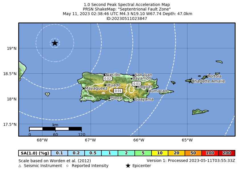 Spectral Acceleration |
 Intensity Map |
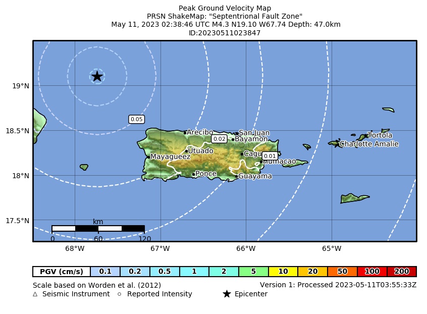 Peak Ground Velocity |
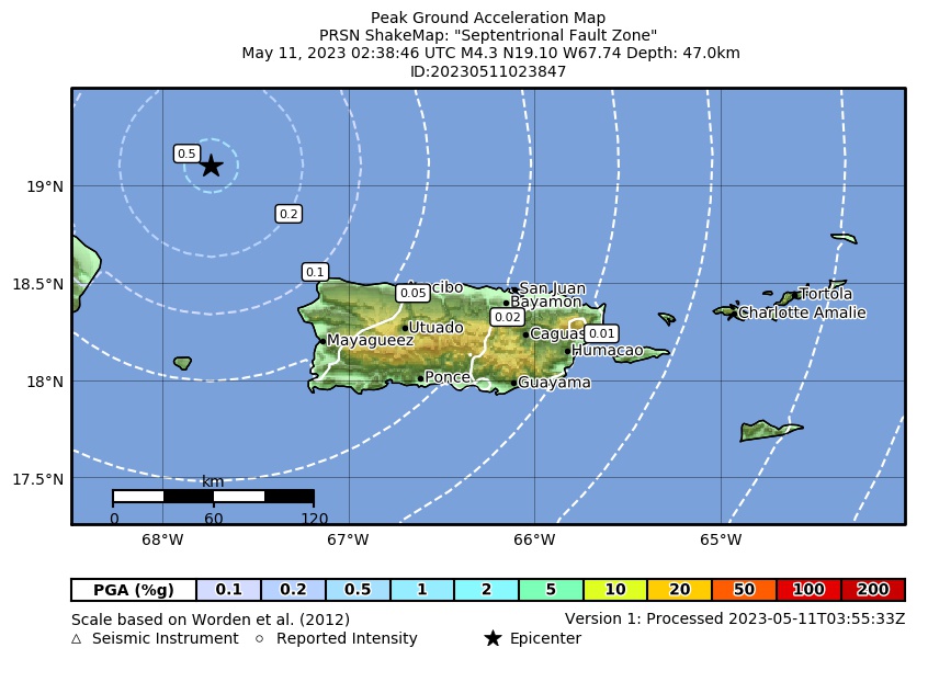 Peak Ground Acceleration |
 DYFI Map |
Google Map for this Event |