
This information is Issued for Puerto Rico and the Virgin Islands.For more information visit your corresponding Seismological Institution or theTsunami Warning Centers
| Event Details | |
|---|---|
| Estimated Maximum Intensity: | V in Guánica, PR |
| Date: |
May 13, 2023 10:59:41 UTC May 13, 2023 06:59:41 Hora Local |
| Region: | South Region of Puerto Rico |
| Distances: |
6.19 Km Southwest of Guánica,PR 11.17 Km Southeast of Lajas,PR 31.85 Km South-Southeast of Mayagüez,PR |
| Magnitude: | 3.69 Md |
| Location: | Latitude: 17.9565 Longitude: -66.9575 |
| Depth: | 13 Km |
| Tsunami Warning Level: | No Warning, Advisory or Watch is in effect for Puerto Rico and the Virgin Islands |
| Issued Date & Time | 2023-05-13 07:35:46 |
| ID: | 20230513105940 |
Epicentral Map
| BULLETIN 2 Seismic Event/Tsunami |
|
|---|---|
| DATE: | May 13, 2023 |
| LOCAL TIME: | 06:59:41 |
| LATITUDE: | 17.9565 N |
| LONGITUDE: | 66.9575 W |
| LOCATION: |
6.2 Km Southwest of Guánica,PR
31.8 Km South-Southeast of Mayagüez,PR |
| DEPTH: | 13 Km |
| MAGNITUDE: | 3.69 Md |
| ESTIMATED MAXIMUM INTENSITY: | V in Guánica, PR |
| TSUNAMI ALERT LEVEL: | No Warning, Advisory or Watch is in effect for Puerto Rico and the Virgin Islands |
| DATE & ISSUED TIME | 2023-05-13 07:35:53 |
|
The Puerto Rico Seismic Network (PRSN) received information that this
minor earthquake was reported as
felt in the Western region of Puerto Rico and the Southern region of Puerto Rico with a maximum
intensity of V (Modified Mercalli Scale, MM).
At the moment of generating this bulletin no damages has been reported, but given the size and location this can not be ruled out Based on magnitude, location and historic records the earthquake was not sufficient to generate a destructive tsunami to Puerto Rico and Virgin Islands. |
|

|
|
Technical Information
YEAR MO DA  --ORIGIN--  --LAT N-  --LON W--  DEPTH   RMS   ERH   ERZ  XMAG  FMAG  PMAG  INT
2023-05-13  1059 41.18  17 57.39   66 57.45  13.69  0.10  0.65  0.39        3.69  3.69D V
                                                                                         SOURCE
NSTA NPHS  DMIN MODEL GAP ITR NFM NWR NWS NVR REMRKS-AVH  N.XMG-XMMAD-T   N.FMG-FMMAD-T  L F X
  48   48   8.5  PR1  203  14  25  21  10  48     Q  PPY   0.00  0.00     19.00  0.12 D

XMAG2-N.XMG2-XMMAD-T-S  FMAG2-N.FMG2-FMMAD-T-S  PREF.MAG-N.PMAG-PRMAD-T
                         3.69  19.00  0.12 Z        3.69  19.00  0.12 D

REGION= Southern Puerto Rico

STA NET COM CR DIST AZM  AN P/S WT   SEC (TOBS -TCAL -DLY  =RES)  WT   SR  INFO  CAL DUR-W-FMAG-T -AMP-U-PER-W-XMAG-T
GBPR PR HHZ  A  8.5  76 143 IPU    44.08  2.90  2.86 0.00  0.04  1.47     0.485 0.58 115   3.51 Z
GBPR PR HH2  A  8.5  76 143 ES  1  46.75  5.57  5.09 0.00  0.48  0.00S    0.000
MLPR PR HHZ  A  9.3 279 140 IPD    44.06  2.88  2.93 0.00 -0.05  1.47     0.311 0.55 124   3.61 Z
MLPR PR HH2  A  9.3 279 140 ES  1  46.38  5.20  5.22 0.00 -0.02  0.74S    0.145
CRPR PR HHZ  A 17.0 289 121 IPD    44.92  3.74  3.83 0.00 -0.09  1.47     0.263 0.55 120   3.63 Z
CRPR PR HH2  A 17.0 289 121 ES  1  47.79  6.61  6.82 0.00 -0.21  0.74S    0.112
LSP  PR HHZ  A 27.8 331 107 IPU    46.51  5.33  5.35 0.00 -0.02  1.47     0.217 0.58  87   3.38 Z
LSP  PR HH1  A 27.8 331 107 ES  1  50.85  9.67  9.52 0.00  0.15  0.74S    0.300
PRSN PR HHZ  A 35.0 326  66 IPU    47.56  6.38  6.39 0.00 -0.01  1.47     0.235
PRSN PR HH1  A 35.0 326  66 ES  1  52.40 11.22 11.37 0.00 -0.15  0.74S    0.144
OBIP PR BHZ  A 38.4  75  66 IPD    47.95  6.77  6.86 0.00 -0.09  1.47     0.277 0.87  99   3.38 Z
OBIP PR BHE  A 38.4  75  66 ES  1  53.38 12.20 12.21 0.00 -0.01  0.74S    0.112
UUPR PR HHZ  A 41.3  37  66 IPU    48.45  7.27  7.27 0.00  0.00  1.47     0.149 0.55 110   3.69 Z
UUPR PR HH1  A 41.3  37  66 ES  1  53.88 12.70 12.94 0.00 -0.24  0.66S    0.143
CELP PR HHZ  A 42.2  71  66 IPD    48.59  7.41  7.39 0.00  0.02  1.47     0.242 0.55 133   3.86 Z
CELP PR HH1  A 42.2  71  66 ES  1  54.17 12.99 13.15 0.00 -0.16  0.74S    0.107
AOPR PR HHZ  A 48.3  26  66 IPU    49.39  8.21  8.25 0.00 -0.04  1.47     0.152 0.55 115   3.74 Z
AOPR PR HH1  A 48.3  26  66 ES  1  55.58 14.40 14.68 0.00 -0.29  0.24S    0.022
AGPR PR HHZ  A 58.9 344  66 IPU    51.14  9.96  9.74 0.00  0.22  1.42     0.150 0.55  82   3.44 Z
AGPR PR HH2  A 58.9 344  66 ES  1  58.38 17.20 17.34 0.00 -0.14  0.71S    0.152
IDE  PR EHZ  A 71.8 312  55 IPD    52.80 11.62 11.56 0.00  0.06  1.03     0.258 0.58 109   3.69 Z
IDE  PR EHE  A 71.8 312  55 ES  1  62.05 20.87 20.58 0.00  0.29  0.17S    0.012
EMPR PR HHZ  A 73.3  38  55 EP+ 1  53.62 12.44 11.74 0.00  0.70* 0.00     0.000 0.55 108   3.71 Z
EMPR PR HH1  A 73.3  38  55 ES  1  63.13 21.95 20.90 0.00  1.05* 0.00S    0.000
SJG  IU BHZ  A 87.2  78  55 EP- 1  54.97 13.79 13.51 0.00  0.28  0.10     0.001
SJG  IU BH1  A 87.2  78  55 ES  1  66.18 25.00 24.05 0.00  0.95* 0.00S    0.000
IGPR PR HHZ  A 90.1  89  55 IPD    55.64 14.46 13.87 0.00  0.59* 0.00     0.000 0.55 105   3.70 Z
IGPR PR HH1  A 90.1  89  55 ES  1  67.72 26.54 24.69 0.00  1.85* 0.00S    0.000
GCPR PR HHZ  A100.4  66  55 EP- 1  56.77 15.59 15.17 0.00  0.42  0.00     0.000 0.55  94   3.61 Z
GCPR PR HH2  A100.4  66  55 ES  1  68.78 27.60 27.00 0.00  0.60* 0.00S    0.000
IMPR PR HHZ  A104.0 278  55 EP- 2  57.44 16.26 15.63 0.00  0.63* 0.00     0.000 0.55  90   3.57 Z
IMPR PR HH2  A104.0 278  55 ES  2  70.00 28.82 27.82 0.00  1.00* 0.00S    0.000
HUMP PR HHZ  A119.2  79  55 EP+ 1  59.65 18.47 17.55 0.00  0.92* 0.00     0.000 0.55 106   3.74 Z
HUMP PR HH2  A119.2  79  55 ES  1  74.08 32.90 31.24 0.00  1.66* 0.00S    0.000
FAPR PR HHZ  A140.7  77  55 IPU    64.08 22.90 20.28 0.00  2.62* 0.00     0.000
FAPR PR HH1  A140.7  77  55 ES  1  80.25 39.07 36.10 0.00  2.97* 0.00S    0.000
MTP  PR HHZ  A149.6  83  55 EP+ 1  64.31 23.13 21.40 0.00  1.73* 0.00     0.000 0.55 118   3.87 Z
MTP  PR HH2  A149.6  83  55 ES  1  82.08 40.90 38.09 0.00  2.81* 0.00S    0.000
PCDR PR BHZ  A162.7 293  55 EP- 3  63.74 22.56 23.07 0.00 -0.51* 0.00     0.000
CUPR PR HHZ  A181.5  77  55 EP- 2  69.29 28.11 25.44 0.00  2.67* 0.00     0.000 0.55 108   3.83 Z
CUPR PR HH2  A181.5  77  55 ES  2  88.70 47.52 45.28 0.00  2.24* 0.00S    0.000
STVI PR HHZ  A216.3  77  55 EP- 3  73.75 32.57 29.84 0.00  2.73* 0.00     0.000
STVI PR HH2  A216.3  77  55 ES  3  95.73 54.55 53.12 0.00  1.43* 0.00S    0.000
CDVI PR HHZ  A233.6  95  55 EP- 2  73.67 32.49 32.03 0.00  0.46  0.00     0.000
SJVI PR HHZ  A235.0  79  55 EP+ 2  75.95 34.77 32.22 0.00  2.55* 0.00     0.000 0.55 112   3.92 Z
SJVI PR HH1  A235.0  79  55 ES  2 100.33 59.15 57.35 0.00  1.80* 0.00S    0.000
HMDR DR BHZ  A272.2 291  55 EP- 3  81.23 40.05 36.93 0.00  3.12* 0.00     0.000 0.00 134   3.27 Z
HMDR DR BHE  A272.2 291  55 ES  3 112.38 71.20 65.74 0.00  5.46* 0.00S    0.000
Event Maps
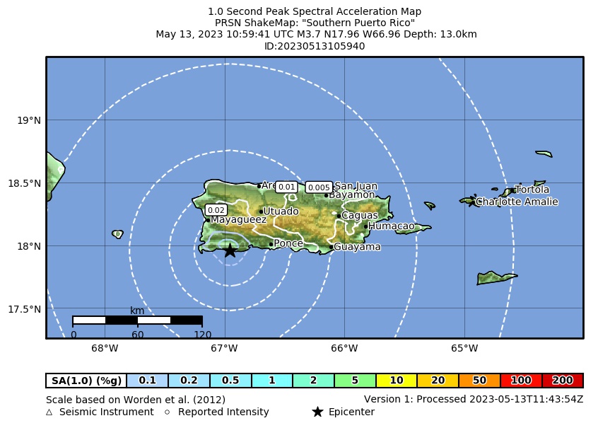 Spectral Acceleration |
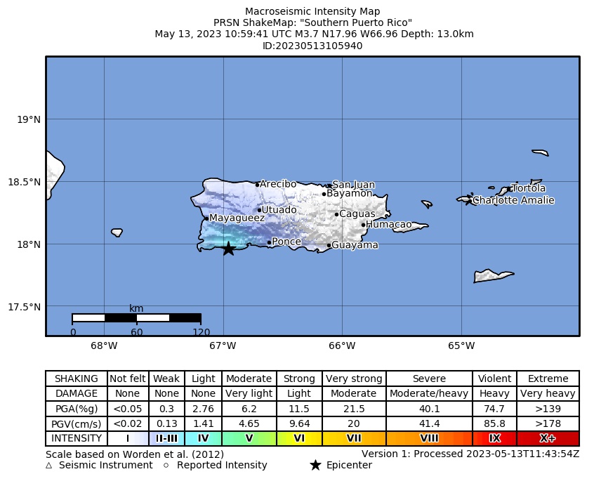 Intensity Map |
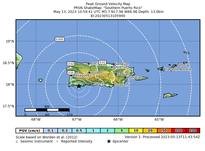 Peak Ground Velocity |
 Peak Ground Acceleration |
 DYFI Map |
Google Map for this Event |