
This information is Issued for Puerto Rico and the Virgin Islands.For more information visit your corresponding Seismological Institution or theTsunami Warning Centers
| Event Details | |
|---|---|
| Estimated Maximum Intensity: | IV in Sabana Grande, PR |
| Date: |
May 13, 2023 17:41:21 UTC May 13, 2023 13:41:21 Hora Local |
| Region: | South Region of Puerto Rico |
| Distances: |
5.46 Km North-Northwest of Guánica,PR 6.87 Km South-Southeast of Sabana Grande,PR 26.79 Km Southeast of Mayagüez,PR |
| Magnitude: | 3.57 Md |
| Location: | Latitude: 18.0375 Longitude: -66.9278 |
| Depth: | 9 Km |
| Tsunami Warning Level: | No Warning, Advisory or Watch is in effect for Puerto Rico and the Virgin Islands |
| Issued Date & Time | 2023-05-13 14:07:49 |
| ID: | 20230513174121 |
Epicentral Map
| BULLETIN 2 Seismic Event/Tsunami |
|
|---|---|
| DATE: | May 13, 2023 |
| LOCAL TIME: | 13:41:21 |
| LATITUDE: | 18.0375 N |
| LONGITUDE: | 66.9278 W |
| LOCATION: |
5.5 Km North-Northwest of Guánica,PR
26.8 Km Southeast of Mayagüez,PR |
| DEPTH: | 9 Km |
| MAGNITUDE: | 3.57 Md |
| ESTIMATED MAXIMUM INTENSITY: | IV in Sabana Grande, PR |
| TSUNAMI ALERT LEVEL: | No Warning, Advisory or Watch is in effect for Puerto Rico and the Virgin Islands |
| DATE & ISSUED TIME | 2023-05-13 14:07:55 |
|
The Puerto Rico Seismic Network (PRSN) received information that this
minor earthquake was reported as
felt in Guánica, Sabana Grande and San Germán with a maximum
intensity of IV (Modified Mercalli Scale, MM).
At the moment of generating this bulletin no damages has been reported, but given the size and location this can not be ruled out Based on magnitude, location and historic records the earthquake was not sufficient to generate a destructive tsunami to Puerto Rico and Virgin Islands. |
|

|
|
Technical Information
YEAR MO DA  --ORIGIN--  --LAT N-  --LON W--  DEPTH   RMS   ERH   ERZ  XMAG  FMAG  PMAG  INT
2023-05-13  1741 21.29  18  2.25   66 55.67   9.43  0.14  0.33  0.87        3.57  3.57D IV
                                                                                         SOURCE
NSTA NPHS  DMIN MODEL GAP ITR NFM NWR NWS NVR REMRKS-AVH  N.XMG-XMMAD-T   N.FMG-FMMAD-T  L F X
  40   40   8.6  PR1  162  14  20  20  10  40     Q  PPP   0.00  0.00     11.00  0.11 D

XMAG2-N.XMG2-XMMAD-T-S  FMAG2-N.FMG2-FMMAD-T-S  PREF.MAG-N.PMAG-PRMAD-T
                         3.57  11.00  0.11 Z        3.57  11.00  0.11 D

REGION= Southern Puerto Rico

STA NET COM CR DIST AZM  AN P/S WT   SEC (TOBS -TCAL -DLY  =RES)  WT   SR  INFO  CAL DUR-W-FMAG-T -AMP-U-PER-W-XMAG-T
GBPR PR HHZ  A  8.6 143 126 IPD    23.68  2.39  2.39 0.00  0.00  1.89     0.525 0.58  60   2.92 Z
GBPR PR HH2  A  8.6 143 126 ES  1  25.65  4.36  4.25 0.00  0.11  0.94S    0.317
CRPR PR HHZ  A 19.6 260  99 EP+ 1  24.65  3.36  3.96 0.00 -0.60* 0.00     0.000 0.55  79   3.26 Z
CRPR PR HH1  A 19.6 260  99 ES  1  27.53  6.24  7.05 0.00 -0.81* 0.00S    0.000
LSP  PR HHZ  A 22.7 313  96 EP+ 1  25.67  4.38  4.43 0.00 -0.05  0.94     0.075
LSP  PR HH1  A 22.7 313  96 ES  1  29.64  8.35  7.89 0.00  0.46  0.10S    0.002
PRSN PR HHZ  A 30.4 311  94 IPU    26.71  5.42  5.62 0.00 -0.20  1.89     0.316 0.55  73   3.25 Z
PRSN PR HH2  A 30.4 311  94 ES  1  31.23  9.94 10.00 0.00 -0.06  0.94S    0.165
UUPR PR HHZ  A 32.4  42  93 IPU    27.22  5.93  5.93 0.00  0.00  1.89     0.175 0.55 112   3.66 Z
UUPR PR HH2  A 32.4  42  93 ES  1  32.10 10.81 10.56 0.00  0.25  0.94S    0.201
OBIP PR BHZ  A 34.1  88  93 EP+ 1  27.47  6.18  6.19 0.00 -0.01  0.94     0.075
OBIP PR BHE  A 34.1  88  93 ES  1  32.09 10.80 11.02 0.00 -0.22  0.94S    0.130
CELP PR HHZ  A 37.1  83  93 IPU    27.86  6.57  6.66 0.00 -0.09  1.89     0.269 0.55  89   3.48 Z
CELP PR HH1  A 37.1  83  93 ES  1  32.94 11.65 11.85 0.00 -0.20  0.94S    0.126
AOPR PR HHZ  A 38.8  28  92 IPU    28.32  7.03  6.92 0.00  0.11  1.89     0.181 0.55  98   3.57 Z
AOPR PR HH2  A 38.8  28  92 ES  1  33.32 12.03 12.32 0.00 -0.29  0.94S    0.220
AGPR PR HHZ  A 51.4 338  92 IPU    30.25  8.96  8.85 0.00  0.11  1.89     0.209 0.55  91   3.53 Z
AGPR PR HH1  A 51.4 338  92 ES  1  36.80 15.51 15.75 0.00 -0.24  0.94S    0.173
EMPR PR HHZ  A 64.4  40  66 EP+ 1  32.71 11.42 10.78 0.00  0.64* 0.00     0.000 0.55 109   3.71 Z
EMPR PR HH2  A 64.4  40  66 ES  1  40.71 19.42 19.19 0.00  0.23  0.83S    0.231
IDE  PR EHZ  A 68.8 305  66 EP+ 1  32.69 11.40 11.40 0.00  0.00  0.74     0.152 0.58 108   3.68 Z
IDE  PR EHN  A 68.8 305  66 ES  1  41.72 20.43 20.29 0.00  0.14  0.74S    0.278
SJG  IU BHZ  A 82.8  84  55 EP+ 1  35.24 13.95 13.32 0.00  0.63* 0.00     0.000
SJG  IU BH2  A 82.8  84  55 ES  1  44.77 23.48 23.71 0.00 -0.23  0.36S    0.130
IGPR PR HHZ  A 87.3  95  55 EP+ 1  35.33 14.04 13.89 0.00  0.15  0.24     0.030
IGPR PR HH1  A 87.3  95  55 ES  1  46.57 25.28 24.72 0.00  0.56* 0.00S    0.000
GCPR PR HHZ  A 94.2  71  55 EP+ 1  36.40 15.11 14.77 0.00  0.34  0.09     0.003 0.55  92   3.58 Z
GCPR PR HH1  A 94.2  71  55 ES  1  47.51 26.22 26.29 0.00 -0.07  0.09S    0.007
MTP  PR HHZ  A145.7  87  55 EP+ 2  44.80 23.51 21.29 0.00  2.22* 0.00     0.000
MTP  PR HH2  A145.7  87  55 ES  2  61.28 39.99 37.90 0.00  2.09* 0.00S    0.000
PCDR PR BHZ  A162.5 290  55 EP+ 3  47.42 26.13 23.41 0.00  2.72* 0.00     0.000
PCDR PR BHE  A162.5 290  55 ES  3  65.53 44.24 41.67 0.00  2.57* 0.00S    0.000
CUPR PR HHZ  A176.6  80  55 EP+ 3  48.73 27.44 25.20 0.00  2.24* 0.00     0.000 0.55  96   3.71 Z
CUPR PR HH2  A176.6  80  55 ES  3  68.14 46.85 44.86 0.00  1.99* 0.00S    0.000
STVI PR HHZ  A211.5  80  55 EP+ 3  54.23 32.94 29.61 0.00  3.33* 0.00     0.000
STVI PR HH1  A211.5  80  55 ES  3  77.21 55.92 52.71 0.00  3.21* 0.00S    0.000
SJVI PR HHZ  A230.5  81  55 EP- 3  56.33 35.04 32.01 0.00  3.03* 0.00     0.000
SJVI PR HH2  A230.5  81  55 ES  3  82.83 61.54 56.98 0.00  4.56* 0.00S    0.000
HMDR DR BHZ  A272.3 289  55 EP+ 3  62.04 40.75 37.30 0.00  3.45* 0.00     0.000
HMDR DR BHN  A272.3 289  55 ES  3  92.49 71.20 66.39 0.00  4.81* 0.00S    0.000
Event Maps
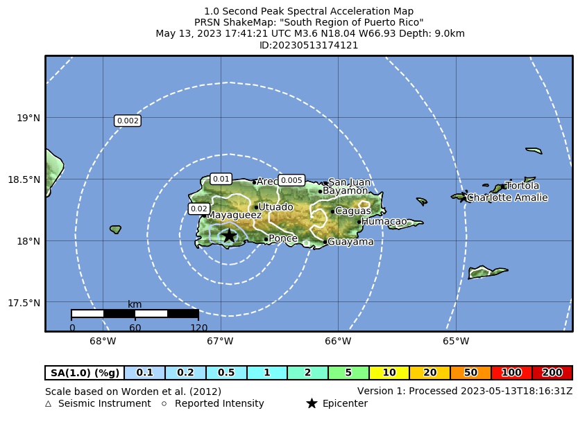 Spectral Acceleration |
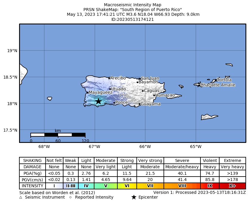 Intensity Map |
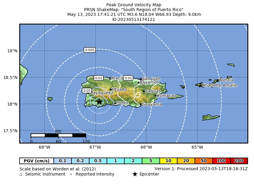 Peak Ground Velocity |
 Peak Ground Acceleration |
 DYFI Map |
Google Map for this Event |