
This information is Issued for Puerto Rico and the Virgin Islands.For more information visit your corresponding Seismological Institution or theTsunami Warning Centers
| Event Details | |
|---|---|
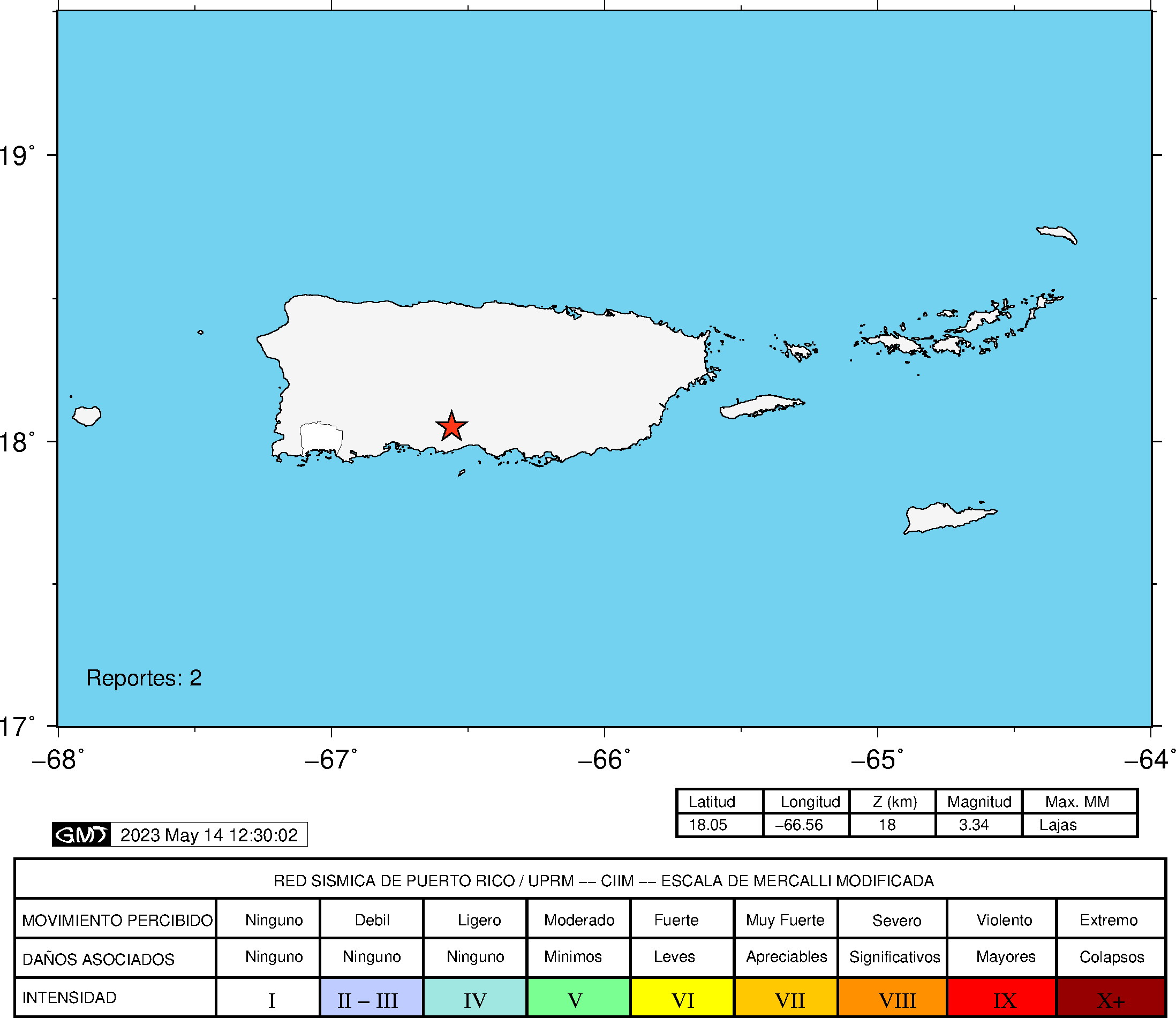
| Estimated Maximum Intensity: | II in Jayuya, PR |
| Date: |
May 14, 2023 01:39:24 UTC May 13, 2023 21:39:24 Hora Local |
| Region: | South Region of Puerto Rico |
| Distances: |
6.67 Km East-Southeast of Ponce,PR 7.73 Km West of Juana Diaz,PR 6.67 Km East-Southeast of Ponce,PR |
| Magnitude: | 3.34 Md |
| Location: | Latitude: 18.0508 Longitude: -66.5633 |
| Depth: | 18 Km |
| Tsunami Warning Level: | No Warning, Advisory or Watch is in effect for Puerto Rico and the Virgin Islands |
| Issued Date & Time | 2023-05-13 22:11:17 |
| ID: | 20230514013923 |
Epicentral Map
| BULLETIN 1 Seismic Event/Tsunami |
|
|---|---|
| DATE: | May 13, 2023 |
| LOCAL TIME: | 21:39:24 |
| LATITUDE: | 18.0508 N |
| LONGITUDE: | 66.5633 W |
| LOCATION: |
7.7 Km West of Juana Diaz,PR
6.7 Km East-Southeast of Ponce,PR |
| DEPTH: | 18 Km |
| MAGNITUDE: | 3.34 Md |
| ESTIMATED MAXIMUM INTENSITY: | II in Jayuya, PR |
| TSUNAMI ALERT LEVEL: | No Warning, Advisory or Watch is in effect for Puerto Rico and the Virgin Islands |
| DATE & ISSUED TIME | 2023-05-13 22:11:25 |
|
The Puerto Rico Seismic Network (PRSN) received information that this
minor earthquake was reported as
felt in Jayuya with a maximum
intensity of II (Modified Mercalli Scale, MM).
At the moment of generating this bulletin no damages has been reported and are not expected to occur Based on magnitude, location and historic records the earthquake was not sufficient to generate a destructive tsunami to Puerto Rico and Virgin Islands. |
|

|
|
Technical Information
YEAR MO DA  --ORIGIN--  --LAT N-  --LON W--  DEPTH   RMS   ERH   ERZ  XMAG  FMAG  PMAG  INT
2023-05-14  0139 24.33  18  3.05   66 33.80  18.34  0.23  0.56  0.40        3.34  3.34D II
                                                                                         SOURCE
NSTA NPHS  DMIN MODEL GAP ITR NFM NWR NWS NVR REMRKS-AVH  N.XMG-XMMAD-T   N.FMG-FMMAD-T  L F X
  36   36   3.1  PR1  156  16  18  26  13  36     Q  PP0   0.00  0.00     15.00  0.13 D

XMAG2-N.XMG2-XMMAD-T-S  FMAG2-N.FMG2-FMMAD-T-S  PREF.MAG-N.PMAG-PRMAD-T
                         3.34  15.00  0.13 Z        3.34  15.00  0.13 D

REGION= Southern Puerto Rico

STA NET COM CR DIST AZM  AN P/S WT   SEC (TOBS -TCAL -DLY  =RES)  WT   SR  INFO  CAL DUR-W-FMAG-T -AMP-U-PER-W-XMAG-T
CELP PR HHZ  A  3.1 328 168 EP- 1  27.51  3.18  3.13 0.00  0.05  1.10     0.117 0.55  66   3.00 Z
CELP PR HH1  A  3.1 328 168 ES  1  29.94  5.61  5.57 0.00  0.04  1.10S    0.259
OBIP PR BHZ  A  4.6 260 163 EP- 1  27.66  3.33  3.18 0.00  0.15  1.10     0.131
OBIP PR BHE  A  4.6 260 163 ES  1  30.03  5.70  5.66 0.00  0.04  1.10S    0.292
UUPR PR HHZ  A 27.8 324 111 EP+ 1  29.75  5.42  5.50 0.00 -0.08  1.10     0.068 0.55  71   3.21 Z
UUPR PR HH1  A 27.8 324 111 ES  1  33.68  9.35  9.79 0.00 -0.44  1.10S    0.194
GBPR PR HHZ  A 34.5 256 105 EP+ 1  30.68  6.35  6.39 0.00 -0.04  1.10     0.100 0.58  74   3.27 Z
GBPR PR HH2  A 34.5 256 105 ES  1  35.90 11.57 11.37 0.00  0.20  1.10S    0.218
AOPR PR HHZ  A 38.5 329 103 EP+ 1  31.31  6.98  6.93 0.00  0.05  1.10     0.074 0.55  83   3.42 Z
AOPR PR HH2  A 38.5 329 103 ES  1  36.16 11.83 12.34 0.00 -0.51* 1.05S    0.196
SJG  IU BHZ  A 44.3  81 100 EP+ 1  32.09  7.76  7.73 0.00  0.03  1.10     0.172 0.73  72   3.18 Z
SJG  IU BH1  A 44.3  81 100 ES  1  37.34 13.01 13.76 0.00 -0.75* 0.00S    0.000
EMPR PR HHZ  A 47.3   4  99 EP+ 1  32.74  8.41  8.15 0.00  0.26  1.10     0.115 0.55  59   3.13 Z
EMPR PR HH1  A 47.3   4  99 ES  1  39.21 14.88 14.51 0.00  0.37  1.10S    0.315
IGPR PR HHZ  A 49.3 100  63 EP+ 1  32.85  8.52  8.41 0.00  0.11  1.10     0.209 0.55  63   3.19 Z
IGPR PR HH1  A 49.3 100  63 ES  1  39.10 14.77 14.97 0.00 -0.20  1.10S    0.409
MLPR PR HHZ  A 51.7 261  63 EP- 1  32.97  8.64  8.72 0.00 -0.08  1.10     0.089 0.55  78   3.39 Z
MLPR PR HH1  A 51.7 261  63 ES  1  39.44 15.11 15.52 0.00 -0.41  1.10S    0.180
LSP  PR HHZ  A 57.0 285  63 EP+ 1  33.64  9.31  9.39 0.00 -0.08  1.08     0.065 0.58  76   3.35 Z
LSP  PR HH2  A 57.0 285  63 ES  1  41.33 17.00 16.71 0.00  0.29  1.08S    0.145
CRPR PR HHZ  A 58.1 266  63 EP- 1  33.90  9.57  9.52 0.00  0.05  1.07     0.078 0.55  87   3.49 Z
CRPR PR HH1  A 58.1 266  63 ES  1  41.16 16.83 16.95 0.00 -0.12  1.07S    0.158
PRSN PR HHZ  A 64.2 287  63 EP- 1  34.61 10.28 10.30 0.00 -0.02  0.97     0.052
PRSN PR HH2  A 64.2 287  63 ES  1  42.84 18.51 18.33 0.00  0.18  0.97S    0.118
AGPR PR HHZ  A 74.0 309  63 EP- 1  36.34 12.01 11.55 0.00  0.46  0.70     0.030 0.55  72   3.34 Z
AGPR PR HH1  A 74.0 309  63 ES  1  45.26 20.93 20.56 0.00  0.37  0.70S    0.080
HUMP PR HHZ  A 76.3  82  63 EP+ 1  36.81 12.48 11.83 0.00  0.65* 0.08     0.001 0.55  72   3.34 Z
HUMP PR HH1  A 76.3  82  63 ES  1  45.32 20.99 21.06 0.00 -0.07  0.63S    0.125
IDE  PR EHZ  A102.5 292  63 EP- 1  40.53 16.20 15.14 0.00  1.06* 0.00     0.000 0.58  64   3.24 Z
IDE  PR EHN  A102.5 292  63 ES  1  52.25 27.92 26.95 0.00  0.97* 0.00S    0.000
MTP  PR HHZ  A107.1  87  63 EP- 1  41.74 17.41 15.73 0.00  1.68* 0.00     0.000 0.55  84   3.52 Z
MTP  PR HH1  A107.1  87  63 ES  1  53.50 29.17 28.00 0.00  1.17* 0.00S    0.000
CUPR PR HHZ  A138.5  77  63 EP- 1  46.02 21.69 19.70 0.00  1.99* 0.00     0.000 0.55  84   3.55 Z
CUPR PR HH1  A138.5  77  63 ES  1  61.70 37.37 35.07 0.00  2.30* 0.00S    0.000
SJVI PR HHZ  A192.1  80  63 EP- 1  54.00 29.67 26.49 0.00  3.18* 0.00     0.000
SJVI PR HH1  A192.1  80  63 ES  1  74.77 50.44 47.15 0.00  3.29* 0.00S    0.000
Event Maps
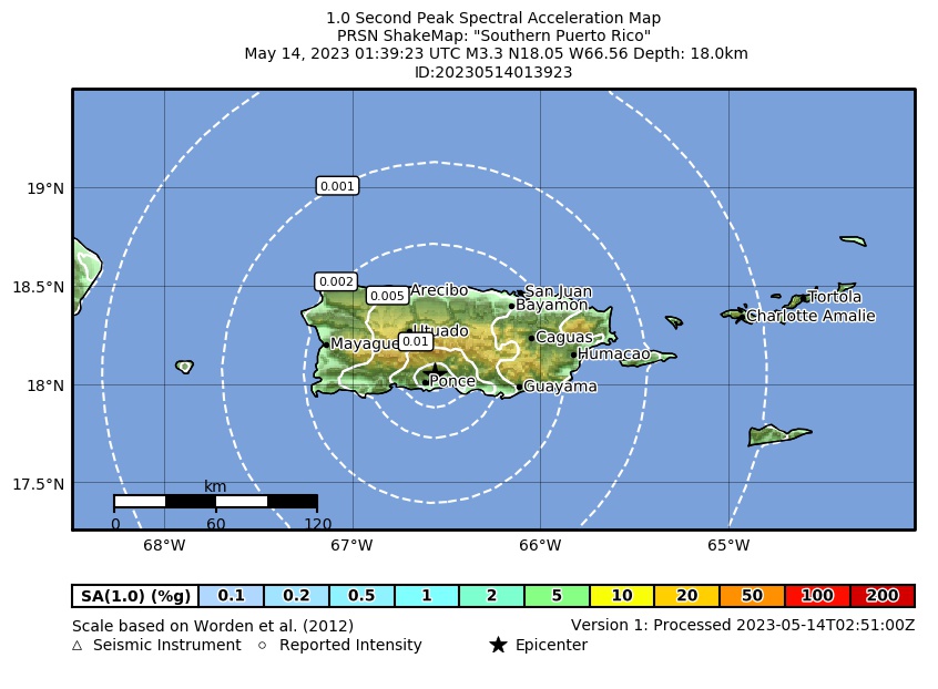 Spectral Acceleration |
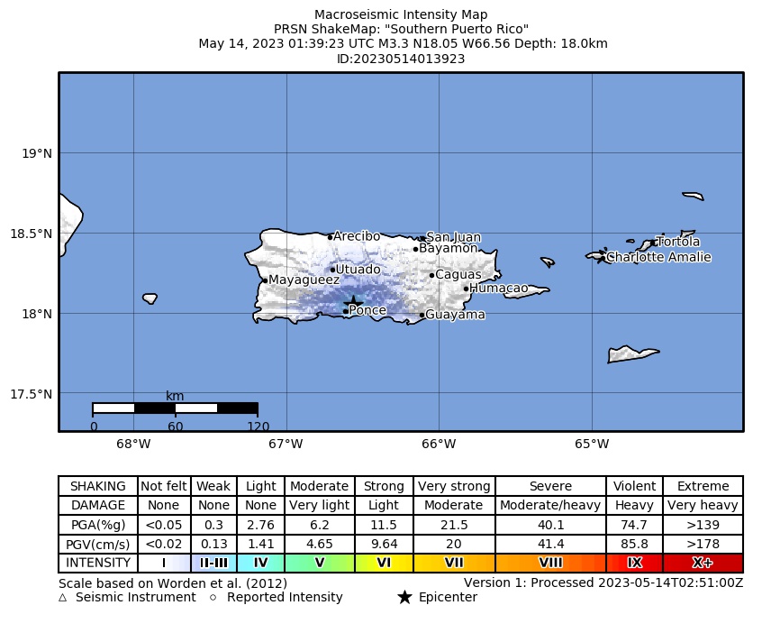 Intensity Map |
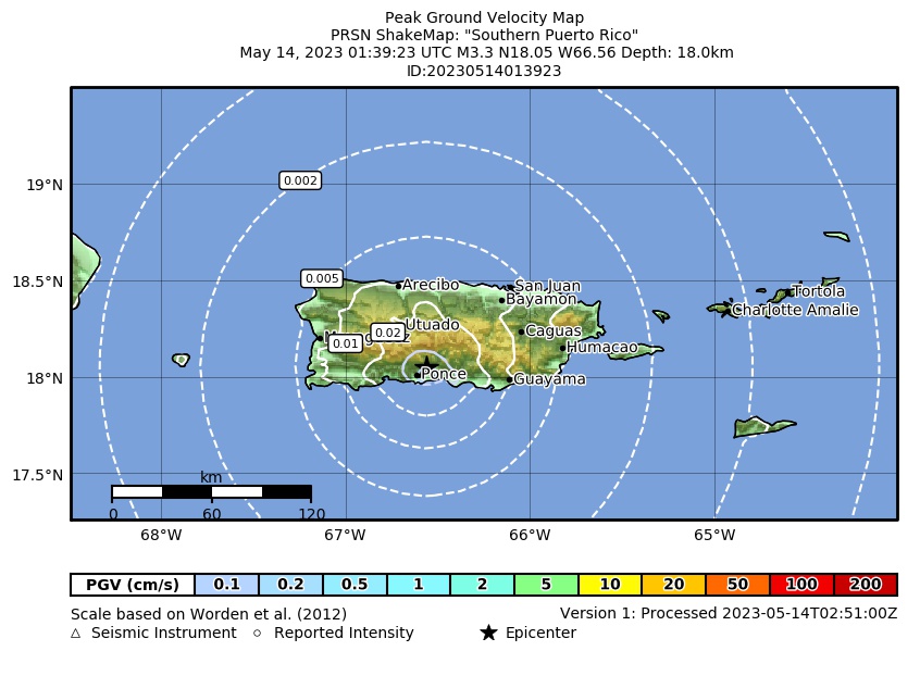 Peak Ground Velocity |
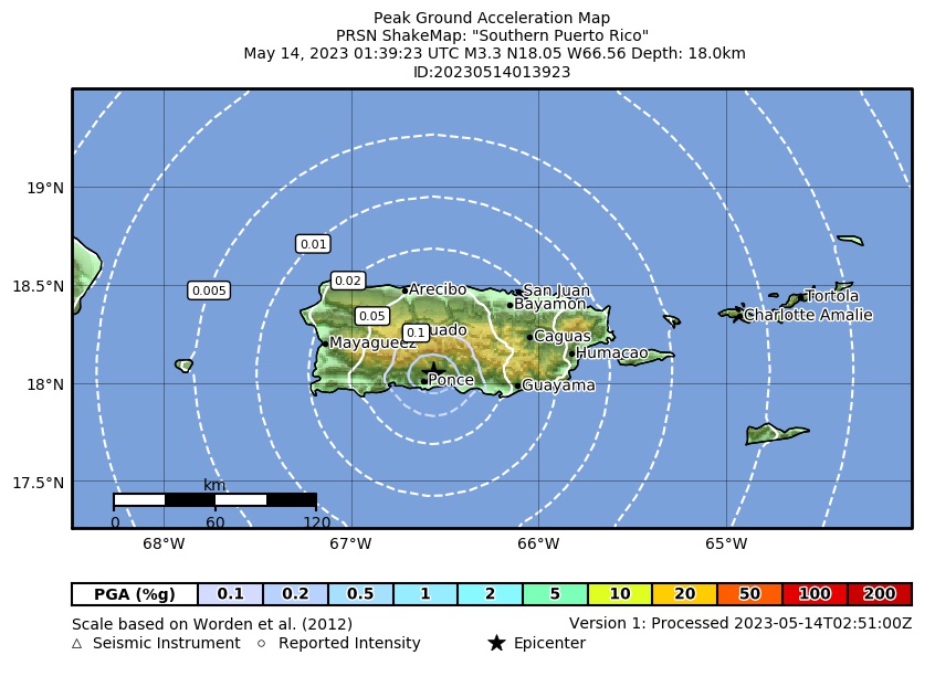 Peak Ground Acceleration |
 DYFI Map |
Google Map for this Event |