
This information is Issued for Puerto Rico and the Virgin Islands.For more information visit your corresponding Seismological Institution or theTsunami Warning Centers
| Event Details | |
|---|---|
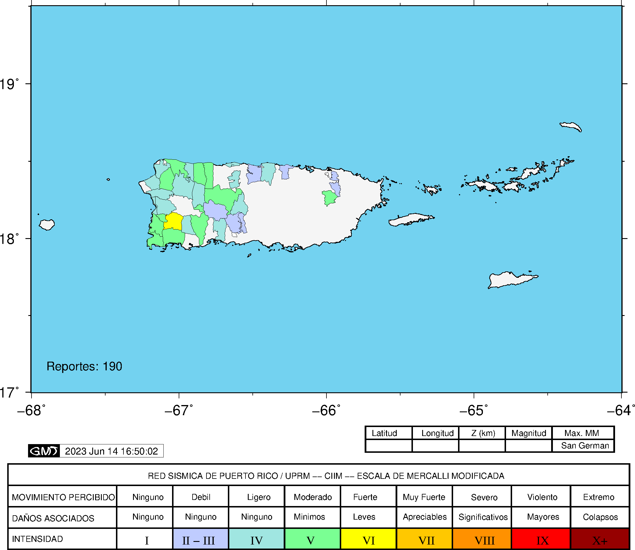
| Estimated Maximum Intensity: | IV in Yauco, PR |
| Date: |
June 14, 2023 03:13:17 UTC June 13, 2023 23:13:17 Hora Local |
| Region: | Central Region of Puerto Rico |
| Distances: |
1.8 Km North of Sabana Grande,PR 6.95 Km South of Maricao,PR 19.63 Km East-Southeast of Mayagüez,PR |
| Magnitude: | 3.6 Ml |
| Location: | Latitude: 18.1121 Longitude: -66.9516 |
| Depth: | 20 Km |
| Tsunami Warning Level: | No Warning, Advisory or Watch is in effect for Puerto Rico and the Virgin Islands |
| Issued Date & Time | 2023-06-13 23:40:51 |
| ID: | 20230614031316 |
Epicentral Map
| BULLETIN 2 Seismic Event/Tsunami |
|
|---|---|
| DATE: | June 13, 2023 |
| LOCAL TIME: | 23:13:17 |
| LATITUDE: | 18.1121 N |
| LONGITUDE: | 66.9516 W |
| LOCATION: |
1.8 Km North of Sabana Grande,PR
19.6 Km East-Southeast of Mayagüez,PR |
| DEPTH: | 20 Km |
| MAGNITUDE: | 3.6 Ml |
| ESTIMATED MAXIMUM INTENSITY: | IV in Yauco, PR |
| TSUNAMI ALERT LEVEL: | No Warning, Advisory or Watch is in effect for Puerto Rico and the Virgin Islands |
| DATE & ISSUED TIME | 2023-06-13 23:40:57 |
|
The Puerto Rico Seismic Network (PRSN) received information that this
minor earthquake was reported as
felt in the Northern region of Puerto Rico, the Western region of Puerto Rico and the Southern region of Puerto Rico with a maximum
intensity of IV (Modified Mercalli Scale, MM).
At the moment of generating this bulletin no damages has been reported, but given the size and location this can not be ruled out Based on magnitude, location and historic records the earthquake was not sufficient to generate a destructive tsunami to Puerto Rico and Virgin Islands. |
|

|
|
Technical Information
YEAR MO DA  --ORIGIN--  --LAT N-  --LON W--  DEPTH   RMS   ERH   ERZ  XMAG  FMAG  PMAG  INT
2023-06-14  0313 17.14  18  6.73   66 57.10  20.73  0.30  0.53  1.62                    IV
                                                                                         SOURCE
NSTA NPHS  DMIN MODEL GAP ITR NFM NWR NWS NVR REMRKS-AVH  N.XMG-XMMAD-T   N.FMG-FMMAD-T  L F X
  48   48  15.8  PR1   61  12  24  32  16  48     Q  PPP   0.00  0.00      0.00  0.00 D

REGION= Central Puerto Rico
Comment: EB 3.6 ml

STA NET COM CR DIST AZM  AN P/S WT   SEC (TOBS -TCAL -DLY  =RES)  WT   SR  INFO  CAL DUR-W-FMAG-T -AMP-U-PER-W-XMAG-T
LSP  PR HHZ  A 15.8 297 130 EP+ 1  21.38  4.24  4.27 0.00 -0.03  0.98     0.078
LSP  PR HH2  A 15.8 297 130 ES  1  25.15  8.01  7.60 0.00  0.41  0.98S    0.349
GBPR PR HHZ  A 17.0 153 127 EP+ 1  21.59  4.45  4.39 0.00  0.06  0.98     0.080
GBPR PR HH2  A 17.0 153 127 ES  1  25.29  8.15  7.81 0.00  0.34  0.98S    0.256
MLPR PR HHZ  A 18.6 212 124 EP+ 1  21.72  4.58  4.55 0.00  0.03  0.98     0.079
MLPR PR HH2  A 18.6 212 124 ES  1  25.23  8.09  8.10 0.00 -0.01  0.98S    0.180
CRPR PR HHZ  A 20.4 236 119 IPD    21.74  4.60  4.74 0.00 -0.14  1.97     0.289
CRPR PR HH1  A 20.4 236 119 ES  1  25.47  8.33  8.44 0.00 -0.11  0.98S    0.144
PRSN PR HHZ  A 23.5 300 113 EP+ 1  21.79  4.65  5.10 0.00 -0.45  0.98     0.049
PRSN PR HH2  A 23.5 300 113 ES  1  26.16  9.02  9.08 0.00 -0.06  0.98S    0.159
UUPR PR HHZ  A 29.0  57 102 EP+ 1  22.60  5.46  5.76 0.00 -0.30  0.98     0.044
UUPR PR HH1  A 29.0  57 102 ES  1  26.80  9.66 10.25 0.00 -0.59* 0.98S    0.191
AOPR PR HHZ  A 33.3  38  96 EP- 1  23.12  5.98  6.30 0.00 -0.32  0.98     0.043
AOPR PR HH2  A 33.3  38  96 ES  1  27.70 10.56 11.21 0.00 -0.65* 0.83S    0.123
OBIP PR BHZ  A 37.4 101  94 EP+ 1  23.89  6.75  6.81 0.00 -0.06  0.98     0.065
OBIP PR BHN  A 37.4 101  94 ES  1  28.78 11.64 12.12 0.00 -0.48  0.98S    0.108
CELP PR HHZ  A 39.7  95  93 IPU    24.01  6.87  7.09 0.00 -0.22  1.97     0.239
CELP PR HH1  A 39.7  95  93 ES  1  29.49 12.35 12.62 0.00 -0.27  0.98S    0.099
AGPR PR HHZ  A 42.8 337  92 IPU    24.40  7.26  7.49 0.00 -0.23  1.97     0.234
AGPR PR HH2  A 42.8 337  92 ES  1  30.03 12.89 13.33 0.00 -0.44  0.98S    0.142
EMPR PR HHZ  A 60.2  47  91 IPD    27.34 10.20  9.70 0.00  0.50* 1.93     0.159
EMPR PR HH1  A 60.2  47  91 ES  1  34.85 17.71 17.27 0.00  0.44  0.97S    0.113
IDE  PR EHZ  A 62.3 300  91 IPU    27.27 10.13  9.96 0.00  0.17  1.90     0.348
IDE  PR EHN  A 62.3 300  91 ES  1  34.94 17.80 17.73 0.00  0.07  0.95S    0.140
ECPR PR HHZ  A 66.4  69  91 IPU    27.75 10.61 10.48 0.00  0.13  1.79     0.143
ECPR PR HH1  A 66.4  69  91 ES  1  35.89 18.75 18.65 0.00  0.10  0.89S    0.074
SJG  IU BHZ  A 84.9  89  90 EP+ 1  30.21 13.07 12.81 0.00  0.26  0.44     0.012
SJG  IU BH1  A 84.9  89  90 ES  1  40.17 23.03 22.80 0.00  0.23  0.44S    0.019
IGPR PR HHZ  A 90.9 100  90 EP+ 1  31.25 14.11 13.58 0.00  0.53* 0.28     0.006
IGPR PR HH1  A 90.9 100  90 ES  1  41.61 24.47 24.17 0.00  0.30  0.28S    0.009
GCPR PR HHZ  A 94.4  76  90 IPU    31.59 14.45 14.02 0.00  0.43  0.40     0.008
GCPR PR HH1  A 94.4  76  90 ES  1  42.62 25.48 24.96 0.00  0.52* 0.20S    0.003
IMPR PR HHZ  A103.8 269  90 EP- 1  32.97 15.83 15.20 0.00  0.63* 0.04     0.000
IMPR PR HH2  A103.8 269  90 ES  1  45.85 28.71 27.06 0.00  1.65* 0.00S    0.000
HUMP PR HHZ  A116.8  88  90 EP+ 2  34.54 17.40 16.85 0.00  0.55* 0.00     0.000
HUMP PR HH1  A116.8  88  90 ES  2  48.43 31.29 29.99 0.00  1.30* 0.00S    0.000
MTP  PR HHZ  A148.1  90  90 EP+ 2  39.35 22.21 20.82 0.00  1.39* 0.00     0.000
MTP  PR HH1  A148.1  90  90 ES  2  56.64 39.50 37.06 0.00  2.44* 0.00S    0.000
PCDR PR BHZ  A157.5 287  90 EP+ 2  41.40 24.26 22.01 0.00  2.25* 0.00     0.000
PCDR PR BHN  A157.5 287  90 ES  2  58.94 41.80 39.18 0.00  2.62* 0.00S    0.000
CUPR PR HHZ  A177.9  82  90 EP+ 2  43.30 26.16 24.59 0.00  1.57* 0.00     0.000
CUPR PR HH2  A177.9  82  90 ES  2  62.97 45.83 43.77 0.00  2.06* 0.00S    0.000
STVI PR HHZ  A212.7  82  90 EP+ 3  47.67 30.53 29.00 0.00  1.53* 0.00     0.000
STVI PR HH1  A212.7  82  90 ES  3  72.52 55.38 51.62 0.00  3.76* 0.00S    0.000
HMDR DR BHZ  A267.4 287  90 EP+ 3  55.78 38.64 35.91 0.00  2.73* 0.00     0.000
HMDR DR BHE  A267.4 287  90 ES  3  85.15 68.01 63.92 0.00  4.09* 0.00S    0.000
SMDR PR BHZ  A269.6 300  90 EP+ 2  57.54 40.40 36.19 0.00  4.21* 0.00     0.000
SMDR PR BHN  A269.6 300  90 ES  2  87.71 70.57 64.42 0.00  6.15* 0.00S    0.000
Event Maps
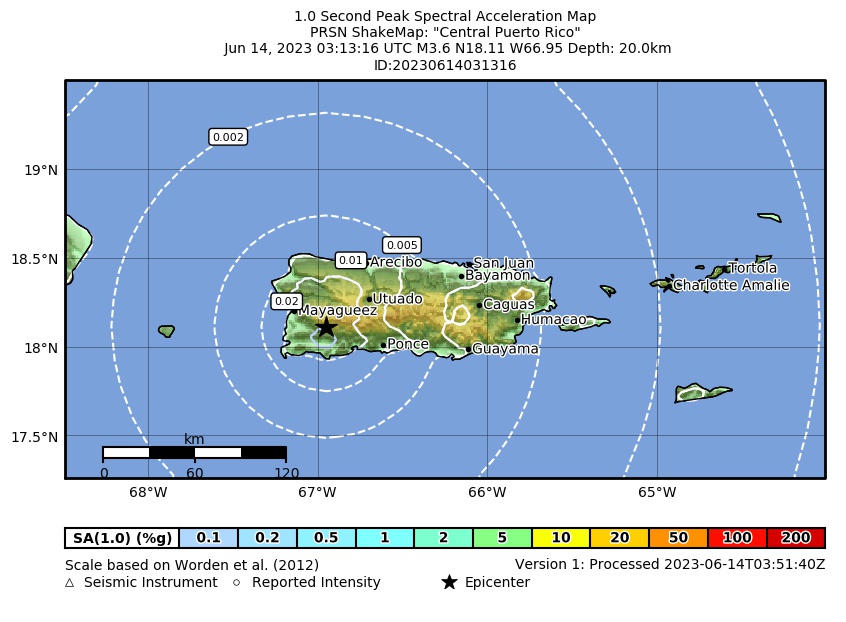 Spectral Acceleration |
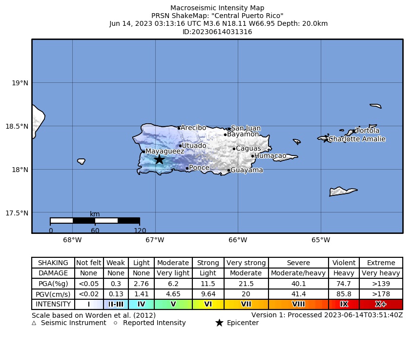 Intensity Map |
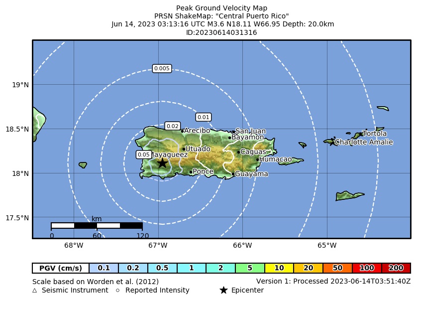 Peak Ground Velocity |
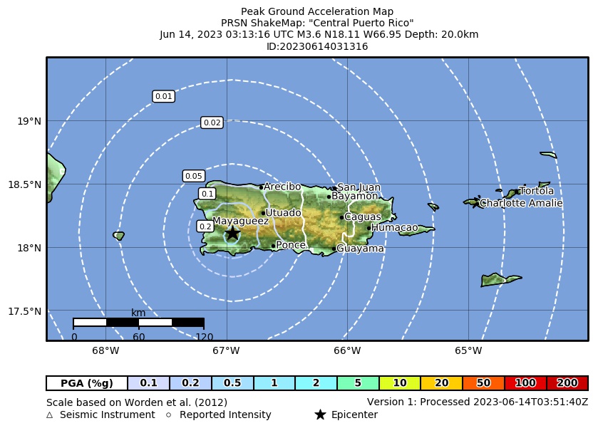 Peak Ground Acceleration |
 DYFI Map |
Google Map for this Event |