
This information is Issued for Puerto Rico and the Virgin Islands.For more information visit your corresponding Seismological Institution or theTsunami Warning Centers
| Event Details | |
|---|---|
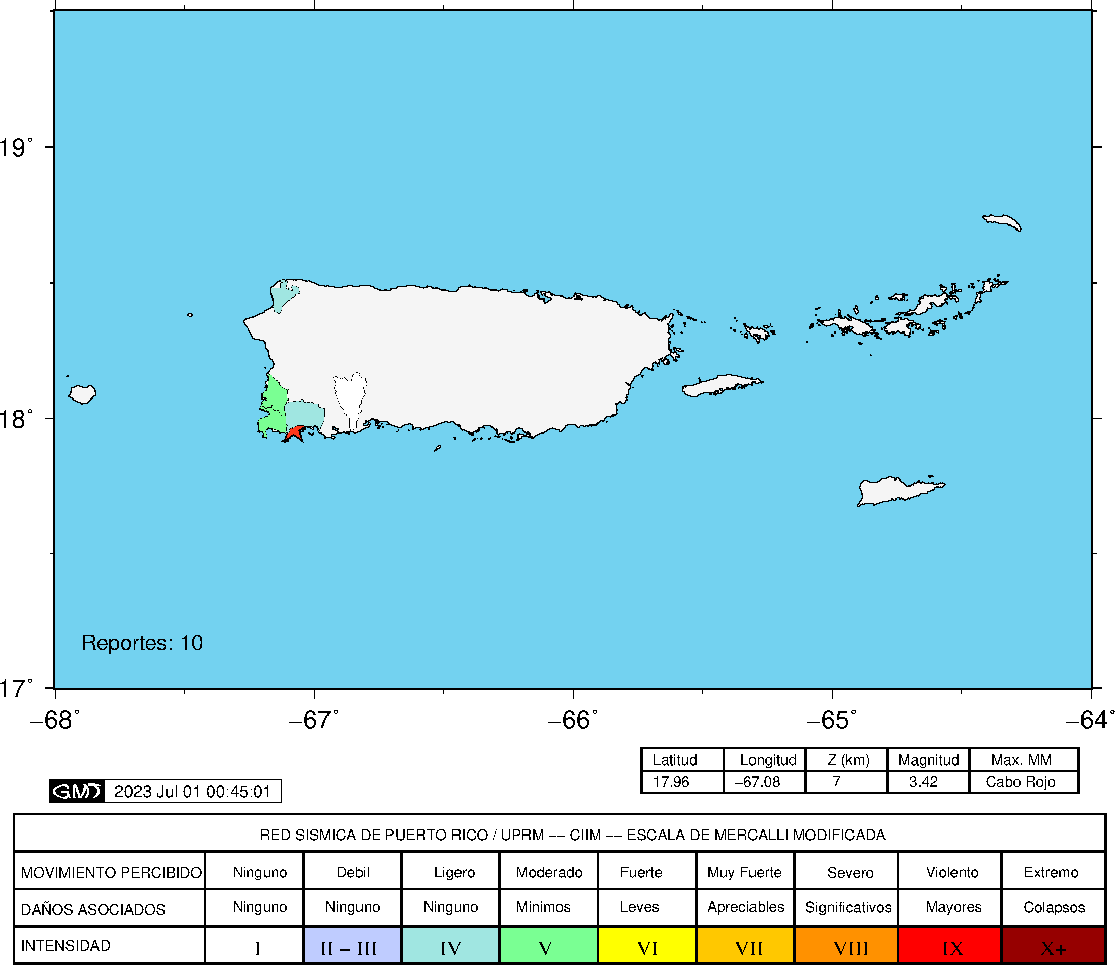
| Estimated Maximum Intensity: | IV in Lajas, PR |
| Date: |
June 30, 2023 17:40:13 UTC June 30, 2023 13:40:13 Hora Local |
| Region: | Southwest Region of Puerto Rico |
| Distances: |
7.62 Km South-Southeast of Lajas,PR 13.65 Km Southeast of Cabo Rojo,PR 27.72 Km South of Mayagüez,PR |
| Magnitude: | 3.42 Md |
| Location: | Latitude: 17.9563 Longitude: -67.0766 |
| Depth: | 7 Km |
| Tsunami Warning Level: | No Warning, Advisory or Watch is in effect for Puerto Rico and the Virgin Islands |
| Issued Date & Time | 2023-06-30 14:00:40 |
| ID: | 20230630174013 |
Epicentral Map
| BULLETIN 1 Seismic Event/Tsunami |
|
|---|---|
| DATE: | June 30, 2023 |
| LOCAL TIME: | 13:40:13 |
| LATITUDE: | 17.9563 N |
| LONGITUDE: | 67.0766 W |
| LOCATION: |
7.6 Km South-Southeast of Lajas,PR
27.7 Km South of Mayagüez,PR |
| DEPTH: | 7 Km |
| MAGNITUDE: | 3.42 Md |
| ESTIMATED MAXIMUM INTENSITY: | IV in Lajas, PR |
| TSUNAMI ALERT LEVEL: | No Warning, Advisory or Watch is in effect for Puerto Rico and the Virgin Islands |
| DATE & ISSUED TIME | 2023-06-30 14:00:47 |
|
The Puerto Rico Seismic Network (PRSN) received information that this
minor earthquake was reported as
felt in Cabo Rojo and Lajas with a maximum
intensity of IV (Modified Mercalli Scale, MM).
At the moment of generating this bulletin no damages has been reported and are not expected to occur Based on magnitude, location and historic records the earthquake was not sufficient to generate a destructive tsunami to Puerto Rico and Virgin Islands. |
|

|
|
Technical Information
YEAR MO DA  --ORIGIN--  --LAT N-  --LON W--  DEPTH   RMS   ERH   ERZ  XMAG  FMAG  PMAG  INT
2023-06-30  1740 13.88  17 57.38   67  4.60   7.55  0.07  0.68  0.15        3.42  3.42D  IV
                                                                                         SOURCE
NSTA NPHS  DMIN MODEL GAP ITR NFM NWR NWS NVR REMRKS-AVH  N.XMG-XMMAD-T   N.FMG-FMMAD-T  L F X
  36   36   3.7  PR1  236  19  18  19   8  36     Q  PPM   0.00  0.00     10.00  0.14 D

XMAG2-N.XMG2-XMMAD-T-S  FMAG2-N.FMG2-FMMAD-T-S  PREF.MAG-N.PMAG-PRMAD-T
                         3.42  10.00  0.14 Z        3.42  10.00  0.14 D

REGION= Southwestern Puerto Rico

STA NET COM CR DIST AZM  AN P/S WT   SEC (TOBS -TCAL -DLY  =RES)  WT   SR  INFO  CAL DUR-W-FMAG-T -AMP-U-PER-W-XMAG-T
MLPR PR HHZ  A  3.7  67 151 IPU    15.56  1.68  1.64 0.00  0.04  1.69     0.410
MLPR PR HH1  A  3.7  67 151 ES  1  16.68  2.80  2.92 0.00 -0.12  0.84S    0.389
CRPR PR HHZ  A  6.5 328 136 IPU    15.87  1.99  1.95 0.00  0.04  1.69     0.416
CRPR PR HH1  A  6.5 328 136 ES  1  17.15  3.27  3.47 0.00 -0.20  0.84S    0.237
GBPR PR HHZ  A 21.0  84  57 IPD    17.97  4.09  4.21 0.00 -0.12  1.69     0.300 0.58  66   3.08 Z
GBPR PR HH1  A 21.0  84  57 ES  1  21.01  7.13  7.49 0.00 -0.36  0.00S    0.000
LSP  PR HHZ  A 24.3 358  57 EP+ 1  18.52  4.64  4.72 0.00 -0.08  0.84     0.064 0.58  80   3.28 Z
LSP  PR HH1  A 24.3 358  57 ES  1  22.32  8.44  8.40 0.00  0.04  0.84S    0.302
PRSN PR HHZ  A 29.8 347  57 IPU    19.44  5.56  5.56 0.00  0.00  1.69     0.337
PRSN PR HH2  A 29.8 347  57 ES  1  23.19  9.31  9.90 0.00 -0.59* 0.00S    0.000
UUPR PR HHZ  A 50.0  48  57 EP+ 1  22.55  8.67  8.67 0.00  0.00  0.84     0.048
UUPR PR HH1  A 50.0  48  57 ES  1  28.61 14.73 15.43 0.00 -0.70* 0.00S    0.000
OBIP PR BHZ  A 50.7  79  57 IPD    22.70  8.82  8.79 0.00  0.03  1.69     0.243 0.87  83   3.24 Z
OBIP PR BHN  A 50.7  79  57 ES  1  29.58 15.70 15.65 0.00  0.05  0.84S    0.173
CELP PR HHZ  A 54.3  75  57 IPD    23.20  9.32  9.33 0.00 -0.01  1.68     0.211 0.55  94   3.56 Z
CELP PR HH1  A 54.3  75  57 ES  1  30.59 16.71 16.61 0.00  0.10  0.84S    0.195
AOPR PR HHZ  A 55.1  38  57 EP+ 1  23.34  9.46  9.45 0.00  0.01  0.84     0.052 0.55  81   3.42 Z
AOPR PR HH2  A 55.1  38  57 ES  1  30.16 16.28 16.82 0.00 -0.54* 0.00S    0.000
AGPR PR HHZ  A 56.7 357  57 EP+ 1  23.71  9.83  9.70 0.00  0.13  0.83     0.063 0.55  80   3.42 Z
AGPR PR HH1  A 56.7 357  57 ES  1  31.13 17.25 17.27 0.00 -0.02  0.83S    0.286
IDE  PR EHZ  A 62.9 320  57 EP+ 1  24.56 10.68 10.66 0.00  0.02  0.77     0.202 0.58  70   3.28 Z
IDE  PR EHN  A 62.9 320  57 ES  1  32.54 18.66 18.97 0.00 -0.31  0.00S    0.000
EMPR PR HHZ  A 81.7  45  50 EP+ 1  27.99 14.11 13.36 0.00  0.75* 0.00     0.000 0.55  92   3.57 Z
EMPR PR HH1  A 81.7  45  50 ES  1  37.62 23.74 23.78 0.00 -0.04  0.35S    0.049
ECPR PR HHZ  A 85.5  61  44 EP+ 1  28.00 14.12 13.85 0.00  0.27  0.08     0.000
ECPR PR HH1  A 85.5  61  44 ES  1  38.54 24.66 24.65 0.00  0.01  0.26S    0.013
IGPR PR HHZ  A102.7  89  44 EP+ 1  30.81 16.93 16.03 0.00  0.90* 0.00     0.000
IGPR PR HH1  A102.7  89  44 ES  1  43.38 29.50 28.53 0.00  0.97* 0.00S    0.000
GCPR PR HHZ  A112.1  69  44 EP+ 1  31.98 18.10 17.22 0.00  0.88* 0.00     0.000
GCPR PR HH1  A112.1  69  44 ES  1  45.74 31.86 30.65 0.00  1.21* 0.00S    0.000
HUMP PR HHZ  A131.6  80  44 EP+ 1  34.40 20.52 19.69 0.00  0.83* 0.00     0.000 0.55  80   3.50 Z
HUMP PR HH2  A131.6  80  44 ES  1  48.89 35.01 35.05 0.00 -0.04  0.00S    0.000
MTP  PR HHZ  A162.1  84  44 EP+ 1  39.54 25.66 23.55 0.00  2.11* 0.00     0.000
MTP  PR HH1  A162.1  84  44 ES  1  55.89 42.01 41.92 0.00  0.09  0.00S    0.000
CUPR PR HHZ  A193.8  78  44 EP+ 1  44.60 30.72 27.56 0.00  3.16* 0.00     0.000 0.55  94   3.71 Z
CUPR PR HH1  A193.8  78  44 ES  1  66.19 52.31 49.06 0.00  3.25* 0.00S    0.000
Event Maps
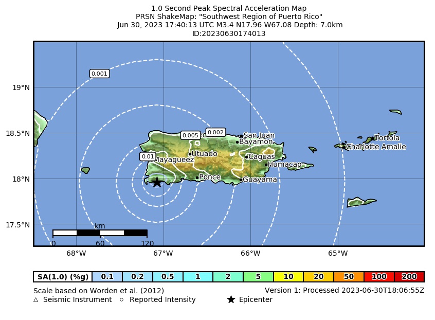 Spectral Acceleration |
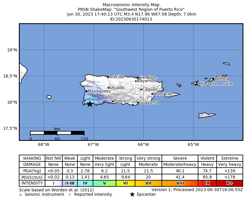 Intensity Map |
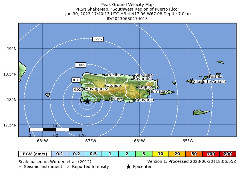 Peak Ground Velocity |
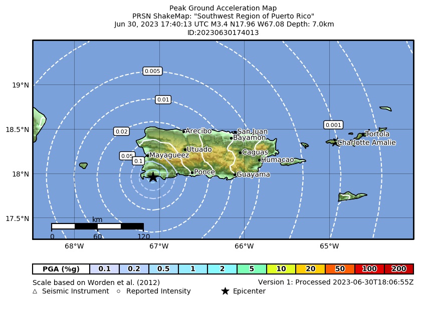 Peak Ground Acceleration |
 DYFI Map |
Google Map for this Event |