
This information is Issued for Puerto Rico and the Virgin Islands.For more information visit your corresponding Seismological Institution or theTsunami Warning Centers
| Event Details | |
|---|---|
| Estimated Maximum Intensity: | IV in Tortola, BVI |
| Date: |
September 03, 2023 07:49:43 UTC September 03, 2023 03:49:43 Hora Local |
| Region: | Virgin Islands Platform |
| Distances: |
30.22 Km Northwest of Anegada,BVI 52.33 Km North-Northwest of Virgin Gorda,BVI 179.61 Km East-Northeast of San Juan,PR |
| Magnitude: | 4.28 Md |
| Location: | Latitude: 18.9421 Longitude: -64.5248 |
| Depth: | 4 Km |
| Tsunami Warning Level: | No Warning, Advisory or Watch is in effect for Puerto Rico and the Virgin Islands |
| Issued Date & Time | 2023-09-03 05:38:36 |
| ID: | 20230903074942 |
Epicentral Map
| BULLETIN 3 Seismic Event/Tsunami |
|
|---|---|
| DATE: | September 03, 2023 |
| LOCAL TIME: | 03:49:43 |
| LATITUDE: | 18.9421 N |
| LONGITUDE: | 64.5248 W |
| LOCATION: |
30.2 Km Northwest of Anegada,BVI
179.6 Km East-Northeast of San Juan,PR |
| DEPTH: | 4 Km |
| MAGNITUDE: | 4.28 Md |
| ESTIMATED MAXIMUM INTENSITY: | IV in Tortola, BVI |
| TSUNAMI ALERT LEVEL: | No Warning, Advisory or Watch is in effect for Puerto Rico and the Virgin Islands |
| DATE & ISSUED TIME | 2023-09-03 05:38:45 |
|
The Puerto Rico Seismic Network (PRSN) received information that this
light earthquake was reported as
felt in the Eastern region of Puerto Rico, the Northern region of Puerto Rico and the British Virgin Islands with a maximum
intensity of IV (Modified Mercalli Scale, MM).
At the moment of generating this bulletin no damages has been reported and are not expected to occur Based on magnitude, location and historic records the earthquake was not sufficient to generate a destructive tsunami to Puerto Rico and Virgin Islands. |
|

|
|
Technical Information
YEAR MO DA --ORIGIN-- --LAT N- --LON W-- DEPTH RMS ERH ERZ XMAG FMAG PMAG INT
2023-09-03 0749 43.70 18 56.53 64 31.49 4.58 0.35 1.18 1.11 4.28 4.28D IV
SOURCE
NSTA NPHS DMIN MODEL GAP ITR NFM NWR NWS NVR REMRKS-AVH N.XMG-XMMAD-T N.FMG-FMMAD-T L F X
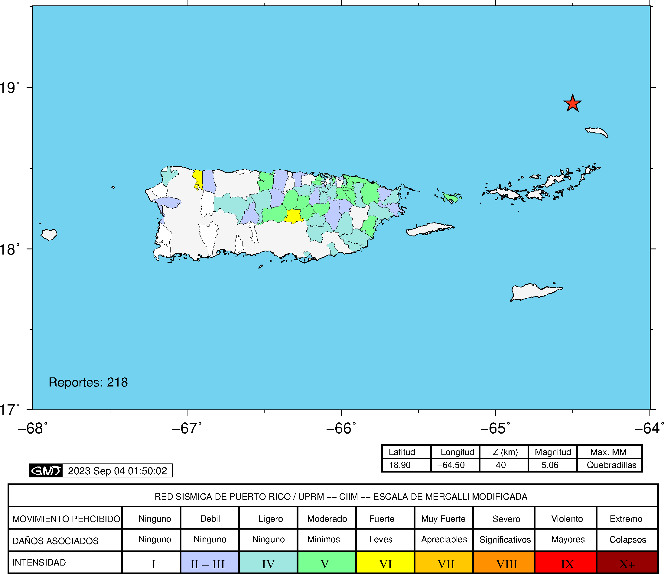
53 53 79.6 PR1 218 16 29 39 16 53 Q PP0 0.00 0.00 14.00 0.07 D
XMAG2-N.XMG2-XMMAD-T-S FMAG2-N.FMG2-FMMAD-T-S PREF.MAG-N.PMAG-PRMAD-T
4.28 14.00 0.07 Z 4.28 14.00 0.07 D
REGION= Virgin Islands Platform
COMMENT= 5.5 Ml (EB), 4.8 Mwr (NEIC) & 5.3 Mi (PTWC)
STA NET COM CR DIST AZM AN P/S WT SEC (TOBS -TCAL -DLY =RES) WT SR INFO CAL DUR-W-FMAG-T -AMP-U-PER-W-XMAG-T
STVI PR HHZ A 79.6 215 50 IPD 56.74 13.04 13.41 0.00 -0.37 2.24 0.338
STVI PR HH2 A 79.6 215 50 ES 1 67.16 23.46 23.87 0.00 -0.41 1.12S 0.234
CDVI PR HHZ A134.1 191 44 IPD 64.63 20.93 20.39 0.00 0.54* 2.24 0.276
CDVI PR HH1 A134.1 191 44 ES 1 80.06 36.36 36.29 0.00 0.07 1.12S 0.244
MTP PR HHZ A143.3 230 44 EP- 1 65.25 21.55 21.55 0.00 0.00 1.12 0.035
MTP PR HH2 A143.3 230 44 ES 1 82.05 38.35 38.36 0.00 -0.01 1.12S 0.107
FAPR PR HHZ A144.0 237 44 EP- 1 65.05 21.35 21.63 0.00 -0.28 1.12 0.034
FAPR PR HH1 A144.0 237 44 ES 1 81.96 38.26 38.50 0.00 -0.24 1.12S 0.091
HUMP PR HHZ A165.5 238 44 EP- 1 67.88 24.18 24.36 0.00 -0.18 1.12 0.034
HUMP PR HH1 A165.5 238 44 ES 1 87.03 43.33 43.36 0.00 -0.03 1.12S 0.089
SMRT NA BHZ A182.2 122 44 EP- 1 69.86 26.16 26.47 0.00 -0.31 1.12 0.187
SMRT NA BHN A182.2 122 44 ES 1 90.43 46.73 47.12 0.00 -0.39 1.12S 0.525
SJG IU BHZ A194.7 243 44 EP+ 1 71.56 27.86 28.06 0.00 -0.20 1.12 0.036
SJG IU BH1 A194.7 243 44 ES 1 93.61 49.91 49.95 0.00 -0.04 1.12S 0.086
IGPR PR HHZ A199.0 238 44 EP- 1 72.69 28.99 28.61 0.00 0.38 1.12 0.034
IGPR PR HH1 A199.0 238 44 ES 1 96.13 52.43 50.93 0.00 1.50* 0.00S 0.000
SABA NA BHZ A199.5 136 44 EP- 1 72.76 29.06 28.66 0.00 0.40 1.12 0.136 0.00 151 3.30 Z
ECPR PR HHZ A205.9 251 44 IPD 72.84 29.14 29.47 0.00 -0.33 2.24 0.178 0.55 174 4.29 Z
ECPR PR HH1 A205.9 251 44 ES 2 96.45 52.75 52.46 0.00 0.29 0.45S 0.015
EMPR PR HHZ A217.7 257 44 EP+ 1 74.58 30.88 30.96 0.00 -0.08 1.12 0.056 0.55 165 4.25 Z
EMPR PR HH1 A217.7 257 44 ES 1 100.22 56.52 55.11 0.00 1.41* 0.04S 0.000
CELP PR HHZ A237.3 247 44 EP- 1 76.92 33.22 33.45 0.00 -0.23 1.12 0.039 0.55 180 4.35 Z
CELP PR HH2 A237.3 247 44 ES 1 103.32 59.62 59.54 0.00 0.08 1.12S 0.088
OBIP PR BHZ A241.3 246 44 EP- 1 78.27 34.57 33.96 0.00 0.61* 1.12 0.038 0.87 166 4.08 Z
OBIP PR BHN A241.3 246 44 ES 1 103.95 60.25 60.45 0.00 -0.20 1.12S 0.087
UUPR PR HHZ A244.0 253 44 EP- 1 78.00 34.30 34.30 0.00 0.00 1.12 0.047 0.55 152 4.21 Z
UUPR PR HH2 A244.0 253 44 ES 2 107.25 63.55 61.05 0.00 2.50* 0.00S 0.000
GBPR PR HHZ A270.8 248 44 EP+ 1 81.85 38.15 37.69 0.00 0.46 1.12 0.040 0.58 160 4.26 Z
GBPR PR HH2 A270.8 248 44 ES 1 112.77 69.07 67.09 0.00 1.98* 0.00S 0.000
AGPR PR HHZ A277.9 260 44 EP+ 1 81.54 37.84 38.59 0.00 -0.75* 1.12 0.063 0.55 168 4.34 Z
AGPR PR HH2 A277.9 260 44 ES 1 112.18 68.48 68.69 0.00 -0.21 1.12S 0.136
MLPR PR HHZ A287.1 249 44 EP- 1 83.61 39.91 39.76 0.00 0.15 1.12 0.041 0.55 166 4.33 Z
MLPR PR HH1 A287.1 249 44 ES 1 115.89 72.19 70.77 0.00 1.42* 0.03S 0.000
PRSN PR HHZ A288.0 255 44 EP- 1 84.37 40.67 39.87 0.00 0.80* 1.12 0.051 0.55 154 4.27 Z
PRSN PR HH2 A288.0 255 44 ES 1 114.61 70.91 70.97 0.00 -0.06 1.12S 0.109
CRPR PR HHZ A292.1 250 44 EP- 1 84.12 40.42 40.38 0.00 0.04 1.11 0.042 0.55 173 4.38 Z
CRPR PR HH2 A292.1 250 44 ES 1 115.75 72.05 71.88 0.00 0.17 1.11S 0.092
IDE PR EHZ A316.6 260 44 EP- 1 87.32 43.62 43.48 0.00 0.14 1.07 0.058 0.58 162 4.32 Z
IDE PR EHN A316.6 260 44 ES 1 121.52 77.82 77.39 0.00 0.43 1.07S 0.124
IMPR PR HHZ A372.4 256 44 EP- 1 96.81 53.11 50.55 0.00 2.56* 0.00 0.000
PCDR PR BHZ A409.7 264 44 EP+ 1 98.89 55.19 55.27 0.00 -0.08 0.61 0.022 0.55 174 4.55 Z
PCDR PR BHN A409.7 264 44 ES 1 144.59100.89 98.38 0.00 2.51* 0.00S 0.000
ABD WI BHZ A422.5 129 44 EP- 1 100.74 57.04 56.89 0.00 0.15 0.53 0.035 0.00 171 3.70 Z
ABD WI BHE A422.5 129 44 ES 1 145.00101.30101.26 0.00 0.04 0.53S 0.101
DSD WI BHZ A468.6 127 44 EP- 1 105.49 61.79 62.73 0.00 -0.94* 0.26 0.008
DSD WI BHN A468.6 127 44 ES 1 154.76111.06111.66 0.00 -0.60* 0.26S 0.024
SMDR PR BHZ A492.6 276 44 EP- 2 107.67 63.97 65.77 0.00 -1.80* 0.00 0.000
SMDR PR BHE A492.6 276 44 ES 2 160.45116.75117.07 0.00 -0.32 0.06S 0.000
HMDR DR BHZ A512.6 269 44 EP- 2 111.09 67.39 68.29 0.00 -0.90* 0.03 0.000
SDD DR BHZ A572.0 266 44 EP- 2 121.43 77.73 75.81 0.00 1.92* 0.00 0.000
SDD DR BHN A572.0 266 44 ES 3 179.26135.56134.94 0.00 0.62* 0.00S 0.000
SC01 DR BHZ A655.7 276 44 EP- 1 129.04 85.34 86.41 0.00 -1.07* 0.00 0.000
SDDR CU BHZ A713.7 272 44 EP- 2 137.44 93.74 93.76 0.00 -0.02 0.00 0.000
Event Maps
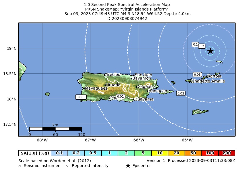 Spectral Acceleration |
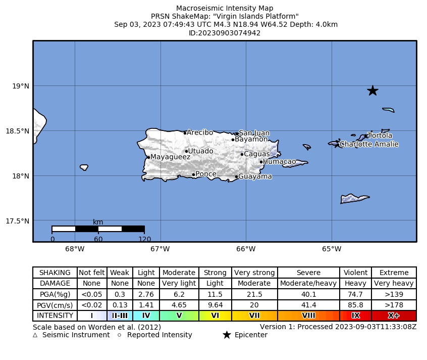 Intensity Map |
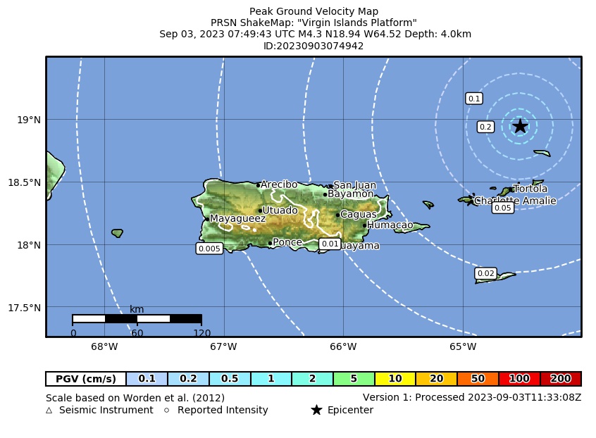 Peak Ground Velocity |
 Peak Ground Acceleration |
 DYFI Map |
Google Map for this Event |