
This information is Issued for Puerto Rico and the Virgin Islands.For more information visit your corresponding Seismological Institution or theTsunami Warning Centers
| Event Details | |
|---|---|
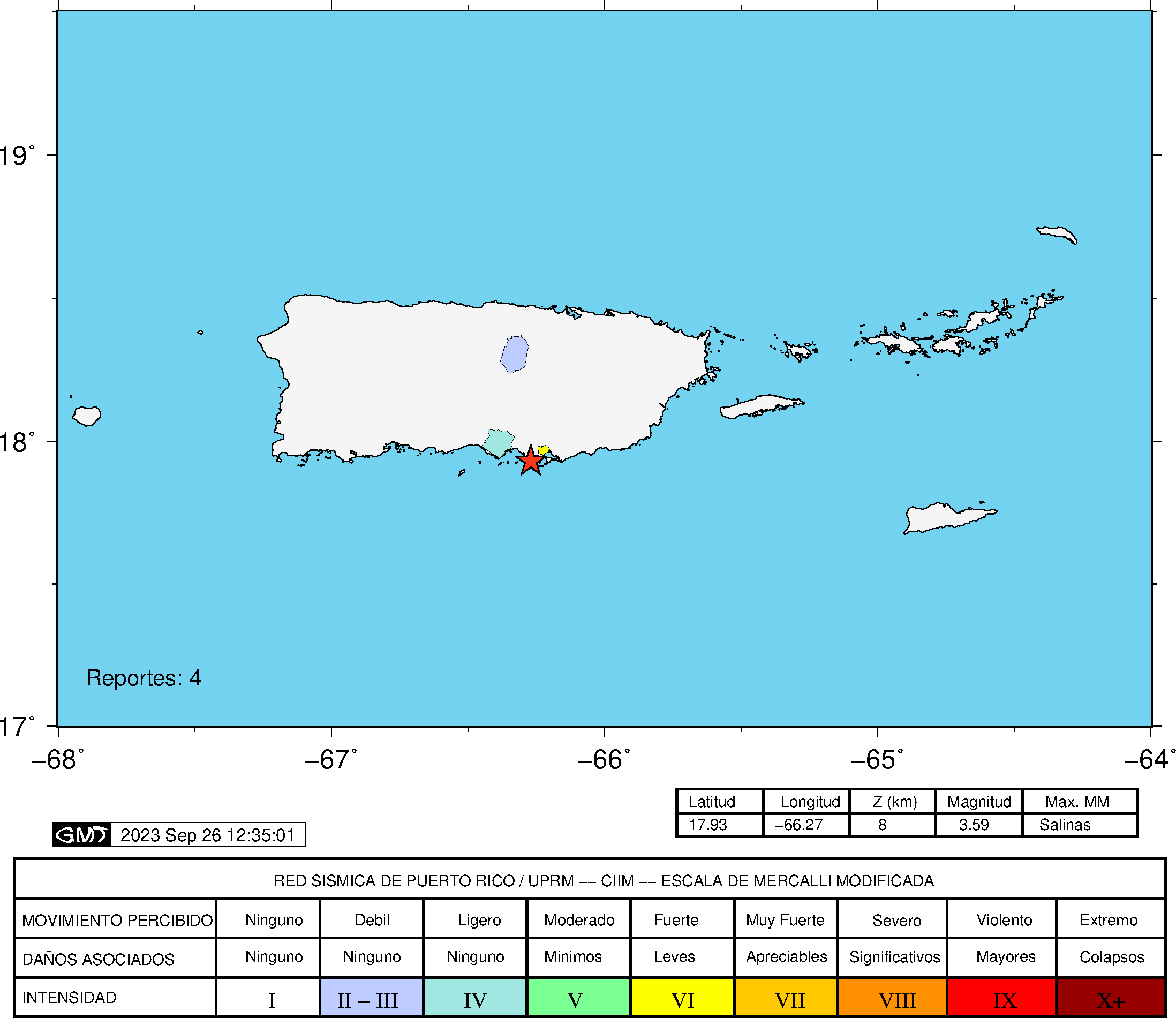
| Estimated Maximum Intensity: | III in Salinas, PR |
| Date: |
September 26, 2023 03:50:09 UTC September 25, 2023 23:50:09 Hora Local |
| Region: | South Region of Puerto Rico |
| Distances: |
10.44 Km South of Salinas,PR 15.24 Km East-Southeast of Santa Isabel,PR 41.78 Km East-Southeast of Ponce,PR |
| Magnitude: | 3.59 Md |
| Location: | Latitude: 17.9258 Longitude: -66.2696 |
| Depth: | 8 Km |
| Tsunami Warning Level: | No Warning, Advisory or Watch is in effect for Puerto Rico and the Virgin Islands |
| Issued Date & Time | 2023-09-26 00:14:30 |
| ID: | 20230926035008 |
Epicentral Map
| BULLETIN 1 Seismic Event/Tsunami |
|
|---|---|
| DATE: | September 25, 2023 |
| LOCAL TIME: | 23:50:09 |
| LATITUDE: | 17.9258 N |
| LONGITUDE: | 66.2696 W |
| LOCATION: |
10.4 Km South of Salinas,PR
41.8 Km East-Southeast of Ponce,PR |
| DEPTH: | 8 Km |
| MAGNITUDE: | 3.59 Md |
| ESTIMATED MAXIMUM INTENSITY: | III in Salinas, PR |
| TSUNAMI ALERT LEVEL: | No Warning, Advisory or Watch is in effect for Puerto Rico and the Virgin Islands |
| DATE & ISSUED TIME | 2023-09-26 00:14:39 |
|
The Puerto Rico Seismic Network (PRSN) received information that this
minor earthquake was reported as
felt in Salinas and San Juan with a maximum
intensity of III (Modified Mercalli Scale, MM).
At the moment of generating this bulletin no damages has been reported, but given the size and location this can not be ruled out Based on magnitude, location and historic records the earthquake was not sufficient to generate a destructive tsunami to Puerto Rico and Virgin Islands. |
|

|
|
Technical Information
YEAR MO DA  --ORIGIN--  --LAT N-  --LON W--  DEPTH   RMS   ERH   ERZ  XMAG  FMAG  PMAG  INT
2023-09-26  0350  9.20  17 55.55   66 16.18   8.08  0.29  0.80  1.27        3.59  3.59D III
                                                                                         SOURCE
NSTA NPHS  DMIN MODEL GAP ITR NFM NWR NWS NVR REMRKS-AVH  N.XMG-XMMAD-T   N.FMG-FMMAD-T  L F X
  34   34  17.8  PR1  199  16  18  26  12  34     Q  PP0   0.00  0.00     13.00  0.06 D

XMAG2-N.XMG2-XMMAD-T-S  FMAG2-N.FMG2-FMMAD-T-S  PREF.MAG-N.PMAG-PRMAD-T
                         3.59  13.00  0.06 Z        3.59  13.00  0.06 D

REGION= Southern Puerto Rico

STA NET COM CR DIST AZM  AN P/S WT   SEC (TOBS -TCAL -DLY  =RES)  WT   SR  INFO  CAL DUR-W-FMAG-T -AMP-U-PER-W-XMAG-T
IGPR PR HHZ  A 17.8  75  90 EP+ 1  13.06  3.86  3.67 0.00  0.19  1.08     0.143 0.55  80   3.26 Z
IGPR PR HH2  A 17.8  75  90 ES  1  16.05  6.85  6.53 0.00  0.32  1.08S    0.176
SJG  IU BHZ  A 24.2  31  90 EP+ 1  14.10  4.90  4.65 0.00  0.25  1.08     0.078
SJG  IU BH1  A 24.2  31  90 ES  1  17.81  8.61  8.28 0.00  0.33  1.08S    0.215
CELP PR HHZ  A 36.7 297  90 EP+ 1  15.33  6.13  6.58 0.00 -0.45  1.08     0.149
CELP PR HH1  A 36.7 297  90 ES  1  20.43 11.23 11.71 0.00 -0.48  1.08S    0.237
GCPR PR HHZ  A 46.8  24  90 EP+ 1  17.21  8.01  8.13 0.00 -0.12  1.08     0.081 0.55  76   3.36 Z
GCPR PR HH1  A 46.8  24  90 ES  1  23.36 14.16 14.47 0.00 -0.31  1.08S    0.246
HUMP PR HHZ  A 50.6  61  90 EP+ 1  17.81  8.61  8.72 0.00 -0.11  1.08     0.101 0.55  70   3.29 Z
HUMP PR HH2  A 50.6  61  90 ES  1  24.18 14.98 15.52 0.00 -0.54* 1.08S    0.137
UUPR PR HHZ  A 59.9 308  90 EP+ 1  18.79  9.59 10.15 0.00 -0.56* 1.08     0.129
UUPR PR HH2  A 59.9 308  90 ES  2  26.06 16.86 18.07 0.00 -1.21* 0.00S    0.000
GBPR PR HHZ  A 64.8 275  90 EP+ 1  19.75 10.55 10.91 0.00 -0.36  1.07     0.221 0.58  98   3.59 Z
EMPR PR HHZ  A 66.9 336  66 IPU    20.57 11.37 11.23 0.00  0.14  2.12     0.259 0.55  91   3.54 Z
EMPR PR HH2  A 66.9 336  66 ES  1  29.32 20.12 19.99 0.00  0.13  1.06S    0.351
FAPR PR HHZ  A 72.4  63  66 EP+ 1  21.10 11.90 12.00 0.00 -0.10  1.01     0.067 0.55  76   3.39 Z
FAPR PR HH1  A 72.4  63  66 ES  1  30.02 20.82 21.36 0.00 -0.54* 1.01S    0.211
MTP  PR HHZ  A 78.3  75  66 IPU    22.12 12.92 12.82 0.00  0.10  1.82     0.296 0.55  94   3.59 Z
MTP  PR HH2  A 78.3  75  66 ES  1  31.70 22.50 22.82 0.00 -0.32  0.91S    0.180
MLPR PR HHZ  A 82.2 274  55 IPU    22.70 13.50 13.36 0.00  0.14  1.65     0.302 0.55  97   3.62 Z
MLPR PR HH2  A 82.2 274  55 ES  1  33.26 24.06 23.78 0.00  0.28  0.83S    0.178
CRPR PR HHZ  A 89.4 276  55 EP+ 1  23.33 14.13 14.28 0.00 -0.15  0.65     0.044 0.55  98   3.64 Z
CRPR PR HH2  A 89.4 276  55 ES  1  34.97 25.77 25.42 0.00  0.35  0.65S    0.107
PRSN PR HHZ  A 98.1 290  55 EP+ 1  24.66 15.46 15.38 0.00  0.08  0.41     0.014
PRSN PR HH1  A 98.1 290  55 ES  1  36.83 27.63 27.38 0.00  0.25  0.41S    0.043
AGPR PR HHZ  A107.3 305  55 IPU    26.33 17.13 16.54 0.00  0.59* 0.38     0.010 0.55 109   3.75 Z
AGPR PR HH1  A107.3 305  55 ES  1  39.04 29.84 29.44 0.00  0.40  0.19S    0.010
IDE  PR EHZ  A136.5 293  55 EP+ 2  30.58 21.38 20.24 0.00  1.14* 0.00     0.000 0.58  84   3.53 Z
IDE  PR EHE  A136.5 293  55 ES  2  48.33 39.13 36.03 0.00  3.10* 0.00S    0.000
STVI PR HHZ  A146.8  71  55 EP+ 2  32.35 23.15 21.54 0.00  1.61* 0.00     0.000 0.55  90   3.62 Z
STVI PR HH2  A146.8  71  55 ES  2  49.66 40.46 38.34 0.00  2.12* 0.00S    0.000
CDVI PR HHZ  A160.7  96  55 EP+ 2  33.72 24.52 23.30 0.00  1.22* 0.00     0.000 0.55 113   3.84 Z
CDVI PR HH1  A160.7  96  55 ES  2  54.58 45.38 41.47 0.00  3.91* 0.00S    0.000
PCDR PR BHZ  A232.7 287  55 EP+ 2  45.56 36.36 32.41 0.00  3.95* 0.00     0.000
Event Maps
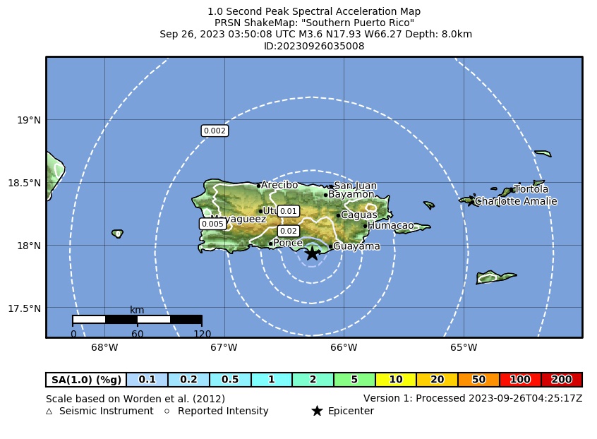 Spectral Acceleration |
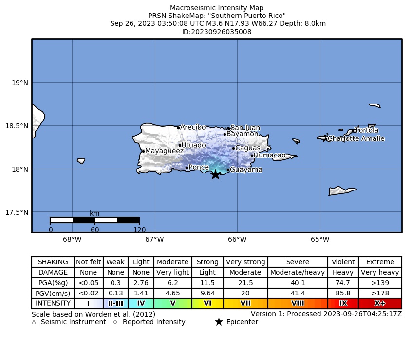 Intensity Map |
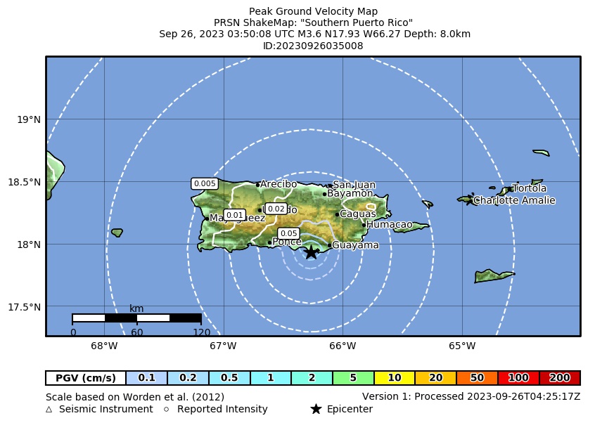 Peak Ground Velocity |
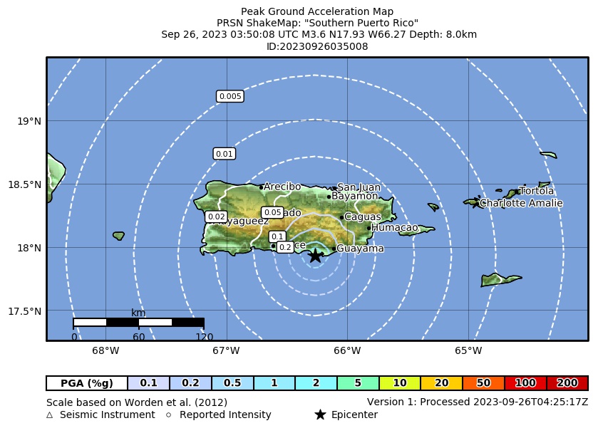 Peak Ground Acceleration |
 DYFI Map |
Google Map for this Event |