
This information is Issued for Puerto Rico and the Virgin Islands.For more information visit your corresponding Seismological Institution or theTsunami Warning Centers
| Event Details | |
|---|---|
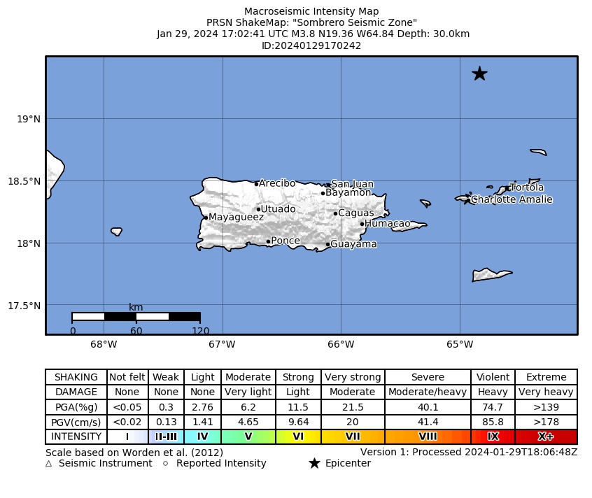
| Estimated Maximum Intensity: | III in Fajardo, PR |
| Date: |
January 29, 2024 17:02:41 UTC January 29, 2024 13:02:41 Hora Local |
| Region: | Sombrero Seismic Zone |
| Distances: |
87.3 Km Northwest of Anegada,BVI 105.96 Km North-Northwest of Road Town, Tortola,BVI 171.69 Km Northeast of San Juan,PR |
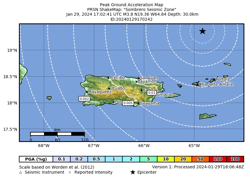
| Magnitude: | 3.84 Md |
| Location: | Latitude: 19.3581 Longitude: -64.8358 |
| Depth: | 30 Km |
| Tsunami Warning Level: | No Warning, Advisory or Watch is in effect for Puerto Rico and the Virgin Islands |
| Issued Date & Time | 2024-01-29 13:44:22 |
| ID: | 20240129170242 |
Epicentral Map
| BULLETIN 2 Seismic Event/Tsunami |
|
|---|---|
| DATE: | January 29, 2024 |
| LOCAL TIME: | 13:02:41 |
| LATITUDE: | 19.3581 N |
| LONGITUDE: | 64.8358 W |
| LOCATION: |
87.3 Km Northwest of Anegada,BVI
171.7 Km Northeast of San Juan,PR |
| DEPTH: | 30 Km |
| MAGNITUDE: | 3.84 Md |
| ESTIMATED MAXIMUM INTENSITY: | III in Fajardo, PR |
| TSUNAMI ALERT LEVEL: | No Warning, Advisory or Watch is in effect for Puerto Rico and the Virgin Islands |
| DATE & ISSUED TIME | 2024-01-29 13:44:27 |
|
The Puerto Rico Seismic Network (PRSN) received information that this
minor earthquake was reported as
felt in the Eastern region of Puerto Rico with a maximum
intensity of III (Modified Mercalli Scale, MM).
At the moment of generating this bulletin no damages has been reported and are not expected to occur Based on magnitude, location and historic records the earthquake was not sufficient to generate a destructive tsunami to Puerto Rico and Virgin Islands. |
|

|
|
Technical Information
YEAR MO DA  --ORIGIN--  --LAT N-  --LON W--  DEPTH   RMS   ERH   ERZ  XMAG  FMAG  PMAG  INT
2024-01-29  1702 41.38  19 21.49   64 50.15  30.11  0.31  2.51 22.24        3.84  3.84D
                                                                                         SOURCE
NSTA NPHS  DMIN MODEL GAP ITR NFM NWR NWS NVR REMRKS-AVH  N.XMG-XMMAD-T   N.FMG-FMMAD-T  L F X
  27   27 112.1  PR1  298  10  14  20   7  22     Q- PPT   0.00  0.00     12.00  0.08 D

XMAG2-N.XMG2-XMMAD-T-S  FMAG2-N.FMG2-FMMAD-T-S  PREF.MAG-N.PMAG-PRMAD-T
                         3.84  12.00  0.08 Z        3.84  12.00  0.08 D

REGION= Sombrero Seismic Zone

STA NET COM CR DIST AZM  AN P/S WT   SEC (TOBS -TCAL -DLY  =RES)  WT   SR  INFO  CAL DUR-W-FMAG-T -AMP-U-PER-W-XMAG-T
STVI PR HHZ  A112.1 187  96 IPU    57.76 16.38 16.33 0.00  0.05  2.29     0.652 0.55 103   3.72 Z
STVI PR HH2  A112.1 187  96 ES  1  70.55 29.17 29.07 0.00  0.10  1.15S    0.512
FAPR PR HHZ  A153.1 215  94 EP+ 1  62.67 21.29 21.51 0.00 -0.22  1.15     0.070 0.55  87   3.61 Z
FAPR PR HH1  A153.1 215  94 ES  1  79.45 38.07 38.29 0.00 -0.22  1.15S    0.270
HUMP PR HHZ  A171.9 219  94 EP+ 1  64.93 23.55 23.87 0.00 -0.32  1.15     0.089 0.55 113   3.87 Z
HUMP PR HH1  A171.9 219  94 ES  1  82.14 40.76 42.49 0.00 -1.73* 0.00S    0.000
GCPR PR HHZ  A175.4 229  93 EP+ 1  64.68 23.30 24.32 0.00 -1.02* 0.38     0.009 0.55 104   3.80 Z
CDVI PR HHZ  A177.9 177  93 EP+ 1  67.91 26.53 24.64 0.00  1.89* 0.00     0.000 0.55 111   3.86 Z
SJG  IU BHZ  A195.6 226  93 EP+ 1  67.75 26.37 26.87 0.00 -0.50  1.15     0.090 0.73 111   3.75 Z
SJG  IU BH2  A195.6 226  93 ES  2  89.66 48.28 47.83 0.00  0.45  0.46S    0.041
ASPR PR HHZ  A208.4 226  93 EP+ 1  69.14 27.76 28.49 0.00 -0.73* 1.15     0.117 0.00 103   2.97 Z
ASPR PR HH1  A208.4 226  93 ES  1  92.16 50.78 50.71 0.00  0.07  1.15S    0.320
CELP PR HHZ  A232.4 233  92 EP+ 1  72.64 31.26 31.52 0.00 -0.26  1.15     0.104 0.55 129   4.05 Z
CELP PR HH1  A232.4 233  92 ES  1  97.63 56.25 56.11 0.00  0.14  1.15S    0.242
UUPR PR HHZ  A233.3 239  92 EP+ 1  73.26 31.88 31.64 0.00  0.24  1.15     0.122
ICMP PR HHZ  A241.6 228  92 EP+ 1  74.20 32.82 32.69 0.00  0.13  1.15     0.173 0.55 109   3.91 Z
AGPR PR HHZ  A259.2 249  92 EP+ 1  76.65 35.27 34.92 0.00  0.35  1.15     0.284 0.55  97   3.82 Z
AGPR PR HH1  A259.2 249  92 ES  1 103.53 62.15 62.16 0.00 -0.01  1.15S    0.716
GBPR PR HHZ  A264.5 235  92 EP+ 1  77.49 36.11 35.58 0.00  0.53* 1.15     0.129 0.58 122   4.02 Z
PRSN PR HHZ  A274.3 243  92 EP+ 3  79.14 37.76 36.82 0.00  0.94* 0.14     0.002
MLPR PR HHZ  A279.2 237  92 EP+ 3  79.04 37.66 37.44 0.00  0.22  0.23     0.005 0.55  97   3.85 Z
MLPR PR HH1  A279.2 237  92 ES  2 108.15 66.77 66.64 0.00  0.13  0.46S    0.042
   5 UNWEIGHTED STATIONS NOT PRINTED.
Event Maps
 Spectral Acceleration |
 Intensity Map |
 Peak Ground Velocity |
 Peak Ground Acceleration |
 DYFI Map |
Google Map for this Event |