
This information is Issued for Puerto Rico and the Virgin Islands.For more information visit your corresponding Seismological Institution or theTsunami Warning Centers
| Event Details | |
|---|---|
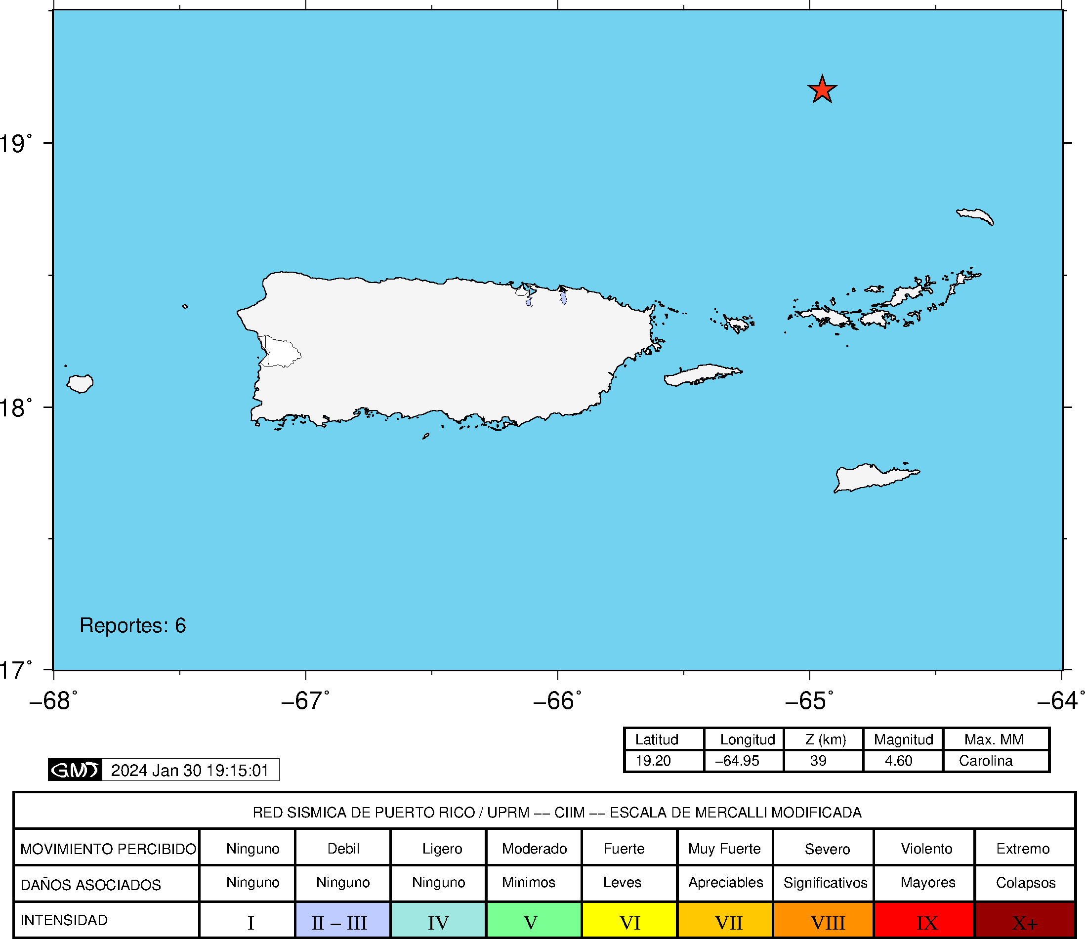
| Estimated Maximum Intensity: | III in Guaynabo, PR |
| Date: |
January 29, 2024 20:00:52 UTC January 29, 2024 16:00:52 Hora Local |
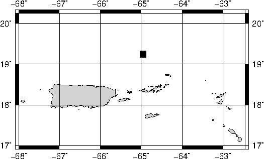
| Region: | Sombrero Seismic Zone |
| Distances: |
87.4 Km Northwest of Anegada,BVI 97.94 Km North-Northwest of Road Town, Tortola,BVI 153.79 Km Northeast of San Juan,PR |
| Magnitude: | 4.6 Ml |
| Location: | Latitude: 19.245 Longitude: -64.954 |
| Depth: | 10 Km |
| Tsunami Warning Level: | No Warning, Advisory or Watch is in effect for Puerto Rico and the Virgin Islands |
| Issued Date & Time | 2024-01-29 16:49:57 |
| ID: | 20240129200051 |
Epicentral Map
| BULLETIN 2 Seismic Event/Tsunami |
|
|---|---|
| DATE: | January 29, 2024 |
| LOCAL TIME: | 16:00:52 |
| LATITUDE: | 19.245 N |
| LONGITUDE: | 64.954 W |
| LOCATION: |
87.4 Km Northwest of Anegada,BVI
153.8 Km Northeast of San Juan,PR |
| DEPTH: | 10 Km |
| MAGNITUDE: | 4.6 Ml |
| ESTIMATED MAXIMUM INTENSITY: | III in Guaynabo, PR |
| TSUNAMI ALERT LEVEL: | No Warning, Advisory or Watch is in effect for Puerto Rico and the Virgin Islands |
| DATE & ISSUED TIME | 2024-01-29 16:50:05 |
|
The Puerto Rico Seismic Network (PRSN) received information that this
light earthquake was reported as
felt in Guaynabo with a maximum
intensity of III (Modified Mercalli Scale, MM).
At the moment of generating this bulletin no damages has been reported and are not expected to occur Based on magnitude, location and historic records the earthquake was not sufficient to generate a destructive tsunami to Puerto Rico and Virgin Islands. |
|
|
|
Technical Information
YEAR MO DA  --ORIGIN--  --LAT N-  --LON W--  DEPTH   RMS   ERH   ERZ  XMAG  FMAG  PMAG  INT
2024-01-29  2000 52.82  19 14.70   64 57.24  10.00  0.43  1.79 31.61        4.22  4.22D III
                                                                                         SOURCE
NSTA NPHS  DMIN MODEL GAP ITR NFM NWR NWS NVR REMRKS-AVH  N.XMG-XMMAD-T   N.FMG-FMMAD-T  L F X
  39   39  98.8  PR1  225  10  24  34  13  39     Q- PPT   0.00  0.00     18.00  0.21 D

XMAG2-N.XMG2-XMMAD-T-S  FMAG2-N.FMG2-FMMAD-T-S  PREF.MAG-N.PMAG-PRMAD-T
                         4.22  18.00  0.21 Z        4.22  18.00  0.21 D

REGION= Sombrero Seismic Zone
COMMENT= EB 4.6ml, USGS 4.9mb, PTWC 4.5ml

STA NET COM CR DIST AZM  AN P/S WT   SEC (TOBS -TCAL -DLY  =RES)  WT   SR  INFO  CAL DUR-W-FMAG-T -AMP-U-PER-W-XMAG-T
STVI PR HHZ  A 98.8 181  55 EP- 1  67.65 14.83 15.30 0.00 -0.47  0.98     0.070 0.55 128   3.89 Z
STVI PR HH2  A 98.8 181  55 ES  1  79.84 27.02 27.23 0.00 -0.21  0.98S    0.300
FAPR PR HHZ  A135.8 214  55 IPD    72.55 19.73 19.98 0.00 -0.25  1.97     0.109 0.55 134   3.97 Z
FAPR PR HH1  A135.8 214  55 ES  1  88.31 35.49 35.56 0.00 -0.07  0.98S    0.154
HUMP PR HHZ  A154.3 218  55 EP- 1  74.75 21.93 22.32 0.00 -0.39  0.98     0.025 0.55 131   3.97 Z
HUMP PR HH1  A154.3 218  55 ES  1  93.23 40.41 39.73 0.00  0.68* 0.98S    0.136
GCPR PR HHZ  A157.9 230  55 EP- 1  74.92 22.10 22.77 0.00 -0.67* 0.98     0.029 0.55 135   4.00 Z
GCPR PR HH2  A157.9 230  55 ES  1  92.89 40.07 40.53 0.00 -0.46  0.98S    0.091
CDVI PR HHZ  A166.4 173  55 EP- 1  77.60 24.78 23.86 0.00  0.92* 0.97     0.081 0.55 180   4.28 Z
CDVI PR HH1  A166.4 173  55 ES  2  96.43 43.61 42.47 0.00  1.14* 0.15S    0.007
SJG  IU BHZ  A177.9 226  55 EP- 1  77.77 24.95 25.31 0.00 -0.36  0.98     0.026 0.73 226   4.37 Z
IGPR PR HHZ  A186.7 221  55 EP- 1  78.92 26.10 26.42 0.00 -0.32  0.98     0.025 0.55 134   4.03 Z
IGPR PR HH2  A186.7 221  55 ES  2 100.26 47.44 47.03 0.00  0.41  0.39S    0.019
ASPR PR HHZ  A190.7 226  55 IPD    79.33 26.51 26.93 0.00 -0.42  1.97     0.107
ASPR PR HH1  A190.7 226  55 ES  1 101.68 48.86 47.94 0.00  0.92* 0.96S    0.099
CELP PR HHZ  A214.9 234  55 IPD    82.82 30.00 29.99 0.00  0.01  1.97     0.137 0.55 262   4.67 Z
CELP PR HH1  A214.9 234  55 ES  1 106.75 53.93 53.38 0.00  0.55* 0.98S    0.083
UUPR PR HHZ  A216.2 240  55 EP+ 1  82.86 30.04 30.16 0.00 -0.12  0.98     0.045 0.55 150   4.16 Z
OBIP PR HHZ  A219.3 233  55 EP- 1  83.32 30.50 30.55 0.00 -0.05  0.98     0.033 0.44 217   4.60 Z
OBIP PR HH1  A219.3 233  55 ES  1 106.38 53.56 54.38 0.00 -0.82* 0.98S    0.085
ICMP PR HHZ  A224.0 229  55 EP- 1  84.28 31.46 31.15 0.00  0.31  0.98     0.028 0.55 226   4.55 Z
SMRT NA BHZ  A238.4 123  55 EP- 1  86.12 33.30 32.96 0.00  0.34  0.98     0.213
SMRT NA BHN  A238.4 123  55 ES  1 111.89 59.07 58.67 0.00  0.40  0.98S    0.375
AGPR PR HHZ  A243.1 250  55 EP+ 1  86.19 33.37 33.56 0.00 -0.19  0.98     0.074 0.55 128   4.05 Z
AGPR PR HH1  A243.1 250  55 ES  1 112.97 60.15 59.74 0.00  0.41  0.98S    0.096
GBPR PR HHZ  A247.1 236  55 EP- 1  87.28 34.46 34.07 0.00  0.39  0.98     0.037
LSP  PR HHZ  A254.1 243  55 EP+ 1  88.64 35.82 34.96 0.00  0.86* 0.98     0.052 0.58 129   4.05 Z
SABA NA BHZ  A255.0 134  55 EP+ 3  90.20 37.38 35.07 0.00  2.31* 0.00     0.000
PRSN PR HHZ  A257.6 245  55 EP+ 1  90.22 37.40 35.39 0.00  2.01* 0.00     0.000 0.55 107   3.90 Z
MLPR PR HHZ  A261.9 238  55 EP+ 1  89.06 36.24 35.95 0.00  0.29  0.98     0.041 0.55 259   4.71 Z
MLPR PR HH1  A261.9 238  55 ES  1 116.72 63.90 63.99 0.00 -0.09  0.98S    0.079
CRPR PR HHZ  A265.6 240  55 EP- 1  89.26 36.44 36.42 0.00  0.02  0.98     0.045 0.55 187   4.42 Z
CRPR PR HH1  A265.6 240  55 ES  2 117.94 65.12 64.83 0.00  0.29  0.39S    0.012
IDE  PR EHZ  A281.5 251  55 EP+ 1  91.23 38.41 38.42 0.00 -0.01  0.98     0.078 0.58 177   4.36 Z
PCDR PR BHZ  A370.2 258  55 EP+ 1 102.99 50.17 49.65 0.00  0.52* 0.97     0.106 0.55 160   4.40 Z
ABD  WI BHZ  A478.8 129  55 EP+ 1 115.47 62.65 63.39 0.00 -0.74* 0.67     0.087
ABD  WI BHN  A478.8 129  55 ES  1 163.95111.13112.83 0.00 -1.70* 0.00S    0.000
DSD  WI BHZ  A525.0 127  55 EP+ 1 120.24 67.42 69.25 0.00 -1.83* 0.00     0.000
DSD  WI BHN  A525.0 127  55 ES  2 174.62121.80123.26 0.00 -1.47* 0.00S    0.000
Event Maps
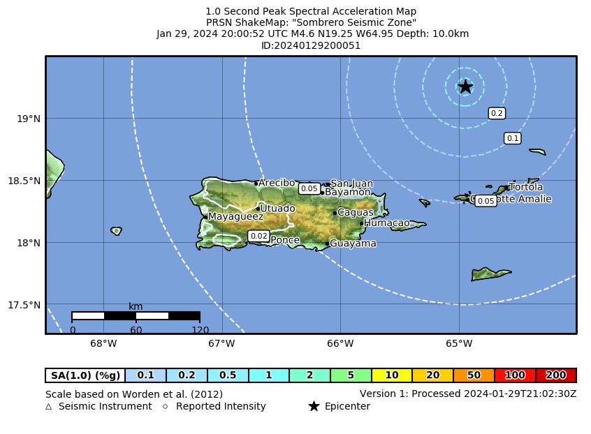 Spectral Acceleration |
 Intensity Map |
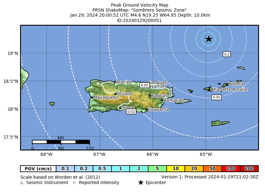 Peak Ground Velocity |
 Peak Ground Acceleration |
 DYFI Map |
Google Map for this Event |