
This information is Issued for Puerto Rico and the Virgin Islands.For more information visit your corresponding Seismological Institution or theTsunami Warning Centers
| Event Details | |
|---|---|
| Estimated Maximum Intensity: | II in Guayama, PR |
| Date: |
February 04, 2024 04:35:23 UTC February 04, 2024 00:35:23 Hora Local |
| Region: | South Region of Puerto Rico |
| Distances: |
11.13 Km South-Southeast of Salinas,PR 13.77 Km Southeast of Santa Isabel,PR 40.11 Km East-Southeast of Ponce,PR |
| Magnitude: | 2.53 Md |
| Location: | Latitude: 17.9238 Longitude: -66.2871 |
| Depth: | 13 Km |
| Tsunami Warning Level: | No Warning, Advisory or Watch is in effect for Puerto Rico and the Virgin Islands |
| Issued Date & Time | 2024-02-04 12:03:43 |
| ID: | 20240204043523 |
Epicentral Map
| BULLETIN 1 Seismic Event/Tsunami |
|
|---|---|
| DATE: | February 04, 2024 |
| LOCAL TIME: | 00:35:23 |
| LATITUDE: | 17.9238 N |
| LONGITUDE: | 66.2871 W |
| LOCATION: |
11.1 Km South-Southeast of Salinas,PR
40.1 Km East-Southeast of Ponce,PR |
| DEPTH: | 13 Km |
| MAGNITUDE: | 2.53 Md |
| ESTIMATED MAXIMUM INTENSITY: | II in Guayama, PR |
| TSUNAMI ALERT LEVEL: | No Warning, Advisory or Watch is in effect for Puerto Rico and the Virgin Islands |
| DATE & ISSUED TIME | 2024-02-04 12:03:53 |
|
The Puerto Rico Seismic Network (PRSN) received information that this
micro earthquake was reported as
felt in Guayama with a maximum
intensity of II (Modified Mercalli Scale, MM).
At the moment of generating this bulletin no damages has been reported and are not expected to occur Based on magnitude, location and historic records the earthquake was not sufficient to generate a destructive tsunami to Puerto Rico and Virgin Islands. |
|

|
|
Technical Information
YEAR MO DA  --ORIGIN--  --LAT N-  --LON W--  DEPTH   RMS   ERH   ERZ  XMAG  FMAG  PMAG  INT
2024-02-04  0435 23.47  17 55.43   66 17.23  13.53  0.16  0.68  0.46        2.53  2.53D   II
                                                                                         SOURCE
NSTA NPHS  DMIN MODEL GAP ITR NFM NWR NWS NVR REMRKS-AVH  N.XMG-XMMAD-T   N.FMG-FMMAD-T  L F X
   9   22  12.7  PR1  185   0  11  18  11  18     Q  A1               N       9 0.154 D  Y Y N

XMAG2-N.XMG2-XMMAD-T-S  FMAG2-N.FMG2-FMMAD-T-S  PREF.MAG-N.PMAG-PRMAD-T
                                                    2.53      9 0.154 D

Event_ID= 71439013
Region= South Region of Puerto Rico
Comment= Revision: 2024-02-04T05:01:57.41

 STA NET COM LOC CR DIST AZM  AN P/S WT  SEC  (TOBS -TCAL -DLY  =RES) WT  SR INFO  CAL DUR-W-FMAG-T -AMP-U-PER-W-XMAG-T
 ASPR PR HHZ 00   A 12.7  25 130 EPU 1  26.97  3.50  3.32    0  0.18 0.10  J   mr       34 1 2.45 Z
 ASPR PR HH1 00   A 12.7  25 130 ES? 1  29.58  6.11  5.92    0  0.19 0.10  J   mr
 IGPR PR HHZ 00   A 19.4  76 116 EPD 1  27.71  4.24  4.19    0  0.05 0.10  J   mr 0.55  30 1 2.38 Z
 IGPR PR HH2 00   A 19.4  76 116 ES? 1  30.63  7.16  7.46    0  -0.3 0.10  J   mr
  SJG IU BHZ 00   A 24.8  35 109 EPU 1  28.52  5.05  4.97    0  0.08 0.10  J   mr 0.00  28 1 2.35 Z
  SJG IU BH1 00   A 24.8  35 109 ES? 1  32.07  8.60  8.85    0 -0.25 0.10  J   mr
 ICMP PR HHZ 00   A 25.4 260 109 EPD 1  28.53  5.06  5.05    0  0.01 0.10  J   mr 0.55  27 1 2.32 Z
 ICMP PR HH2 00   A 25.4 260 109 ES? 1  32.35  8.88  8.99    0 -0.11 0.10  J   mr
 JND1 PR HNZ --   A 28.7 308 106 EPU 1  29.13  5.66  5.54    0  0.12 0.10  J   mr
 JND1 PR HNE --   A 28.7 308 106 ES? 1  33.22  9.75  9.86    0 -0.11 0.10  J   mr
 CELP PR HHZ 00   A 34.7 298  66 IPU 1  29.91  6.44  6.41    0  0.03 0.10  J   mr 0.55  32 1 2.53 Z
 CELP PR HH2 00   A 34.7 298  66 ES? 1  34.68 11.21 11.41    0  -0.2 0.10  J   mr
 GCPR PR HHZ 00   A 47.2  26  66 EPU 1  31.89  8.42  8.19    0  0.23 0.10  J   mr 0.55  43 1 2.84 Z
 GCPR PR HH1 00   A 47.2  26  66 ES? 1  38.11 14.64 14.58    0  0.06 0.10  J   mr
 HUMP PR HHZ 00   A 51.7  62  66 EPU 1  32.46  8.99  8.83    0  0.16 0.10  J   mr 0.55  35 1 2.66 Z
 HUMP PR HH1 00   A 51.7  62  66 ES? 1  38.94 15.47 15.72    0 -0.25 0.10  J   mr
 UUPR PR HHZ 00   A 57.9 308  66 EPU 1  33.33  9.86  9.71    0  0.15 0.10  J   mr 0.55  35 1 2.67 Z
 UUPR PR HH1 00   A 57.9 308  66 ES? 1  40.65 17.18 17.28    0  -0.1 0.10  J   mr
 CRPR PR HHZ 00   A 86.6 276  55 EP? 2  38.07 14.60 13.56    0  1.04 0.00  J   mr 0.55  51 1 3.04 Z
 CRPR PR HH2 00   A 86.6 276  55 ES? 1  48.56 25.09 24.14    0  0.95 0.00  J   mr
 AGPR PR HHZ 00   A104.7 304  55 EP? 2  41.13 17.66 15.88    0  1.78 0.00  J   mr 0.55
 AGPR PR HH1 00   A104.7 304  55 ES? 2  53.53 30.06 28.27    0  1.79 0.00  J   mr
Event Maps
 Spectral Acceleration |
 Intensity Map |
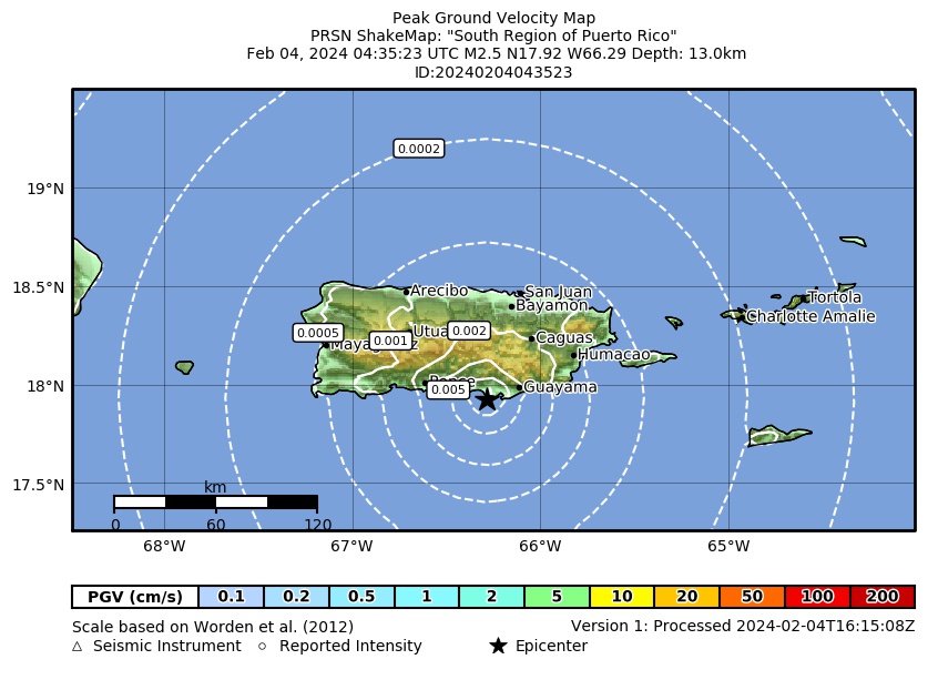 Peak Ground Velocity |
 Peak Ground Acceleration |
 DYFI Map |
Google Map for this Event |