
This information is Issued for Puerto Rico and the Virgin Islands.For more information visit your corresponding Seismological Institution or theTsunami Warning Centers
| Event Details | |
|---|---|
| Estimated Maximum Intensity: | III in Mayagüez, PR |
| Date: |
March 10, 2024 06:29:23 UTC March 10, 2024 02:29:23 Hora Local |
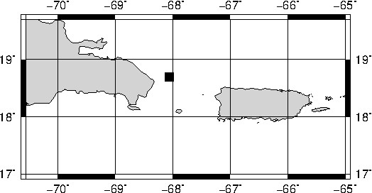
| Region: | Eastern Dominican Republic |
| Distances: |
56.83 Km East of Punta Cana,DR 67.45 Km East of Higüey,DR 118.36 Km West-Northwest of Mayagüez,PR |
| Magnitude: | 3.47 Md |
| Location: | Latitude: 18.6938 Longitude: -68.0623 |
| Depth: | 118 Km |
| Tsunami Warning Level: | No Warning, Advisory or Watch is in effect for Puerto Rico and the Virgin Islands |
| Issued Date & Time | 2024-03-10 03:10:53 |
| ID: | 20240310062923 |
Epicentral Map
| BULLETIN 1 Seismic Event/Tsunami |
|
|---|---|
| DATE: | March 10, 2024 |
| LOCAL TIME: | 02:29:23 |
| LATITUDE: | 18.6938 N |
| LONGITUDE: | 68.0623 W |
| LOCATION: |
56.8 Km East of Punta Cana,DR
118.4 Km West-Northwest of Mayagüez,PR |
| DEPTH: | 118 Km |
| MAGNITUDE: | 3.47 Md |
| ESTIMATED MAXIMUM INTENSITY: | III in Mayagüez, PR |
| TSUNAMI ALERT LEVEL: | No Warning, Advisory or Watch is in effect for Puerto Rico and the Virgin Islands |
| DATE & ISSUED TIME | 2024-03-10 03:10:58 |
|
The Puerto Rico Seismic Network (PRSN) received information that this
minor earthquake was reported as
felt in Mayaguez with a maximum
intensity of III (Modified Mercalli Scale, MM).
At the moment of generating this bulletin no damages has been reported and are not expected to occur Based on magnitude, location and historic records the earthquake was not sufficient to generate a destructive tsunami to Puerto Rico and Virgin Islands. |
|
|
|
Technical Information
YEAR MO DA  --ORIGIN--  --LAT N-  --LON W--  DEPTH   RMS   ERH   ERZ  XMAG  FMAG  PMAG  INT
2024-03-10  0629 23.49  18 41.63   68  3.74 118.45  0.23  3.57  1.85        3.47  3.47D
                                                                                         SOURCE
NSTA NPHS  DMIN MODEL GAP ITR NFM NWR NWS NVR REMRKS-AVH  N.XMG-XMMAD-T   N.FMG-FMMAD-T  L F X
  20   20 118.0  PR1  186  19  10  18   8  20     Q  PPK   0.00  0.00      7.00  0.08 D

XMAG2-N.XMG2-XMMAD-T-S  FMAG2-N.FMG2-FMMAD-T-S  PREF.MAG-N.PMAG-PRMAD-T
                         3.47   7.00  0.08 Z        3.47   7.00  0.08 D

REGION= Eastern Dominican Republic

STA NET COM CR DIST AZM  AN P/S WT   SEC (TOBS -TCAL -DLY  =RES)  WT   SR  INFO  CAL DUR-W-FMAG-T -AMP-U-PER-W-XMAG-T
LSP  PR HHZ  A118.0 118 133 EP+ 1  45.01 21.52 22.17 0.00 -0.65* 0.91     0.047
LSP  PR HH1  A118.0 118 133 ES  1  62.57 39.08 39.46 0.00 -0.38  1.06S    0.258
CRPR PR HHZ  A126.2 126 131 EP+ 1  46.39 22.90 22.93 0.00 -0.03  1.06     0.139 0.55  63   3.46 Z
CRPR PR HH1  A126.2 126 131 ES  1  64.25 40.76 40.82 0.00 -0.06  1.06S    0.284
MLPR PR HHZ  A134.2 126 129 EP+ 1  47.32 23.83 23.70 0.00  0.13  1.06     0.164 0.55  50   3.26 Z
MLPR PR HH1  A134.2 126 129 ES  1  65.85 42.36 42.19 0.00  0.17  1.06S    0.298
HMDR DR BHZ  A139.5 275 128 EP+ 1  47.90 24.41 24.22 0.00  0.19  1.06     0.322 0.00  63   2.62 Z
HMDR DR BHE  A139.5 275 128 ES  1  66.64 43.15 43.11 0.00  0.04  1.06S    0.742
GBPR PR HHZ  A148.2 122 126 EP- 1  48.87 25.38 25.09 0.00  0.29  1.06     0.146 0.58  69   3.55 Z
GBPR PR HH1  A148.2 122 126 ES  1  69.15 45.66 44.66 0.00  1.00* 0.00S    0.000
OBIP PR HHZ  A169.9 114 122 EP- 1  50.67 27.18 27.35 0.00 -0.17  1.06     0.107 0.44  54   3.47 Z
OBIP PR HH1  A169.9 114 122 ES  1  72.42 48.93 48.68 0.00  0.25  1.06S    0.126
CELP PR HHZ  A171.1 113 122 EP- 1  50.91 27.42 27.47 0.00 -0.05  1.06     0.103 0.55  60   3.47 Z
CELP PR HH1  A171.1 113 122 ES  1  72.39 48.90 48.90 0.00  0.00  1.06S    0.129
SJG  IU BHZ  A212.1 107 117 EP+ 1  55.16 31.67 31.98 0.00 -0.31  1.06     0.135
SJG  IU BH1  A212.1 107 117 ES  1  79.55 56.06 56.92 0.00 -0.86* 0.00S    0.000
GCPR PR HHZ  A213.3 101 117 EP- 1  55.54 32.05 32.11 0.00 -0.06  1.06     0.175
GCPR PR HH2  A213.3 101 117 ES  1  80.74 57.25 57.16 0.00  0.09  1.06S    0.424
HUMP PR HHZ  A241.8 104 114 EP+ 1  58.97 35.48 35.36 0.00  0.12  1.06     0.166 0.55  71   3.70 Z
HUMP PR HH1  A241.8 104 114 ES  1  86.75 63.26 62.94 0.00  0.32  1.06S    0.225
Event Maps
 Spectral Acceleration |
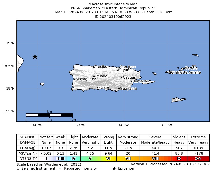 Intensity Map |
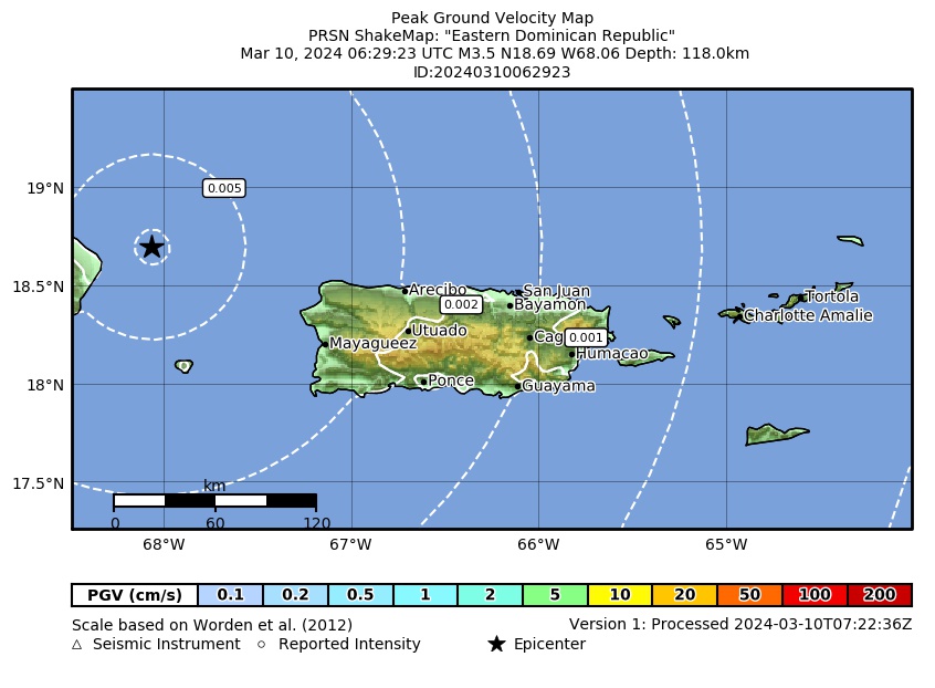 Peak Ground Velocity |
 Peak Ground Acceleration |
 DYFI Map |
Google Map for this Event |