
This information is Issued for Puerto Rico and the Virgin Islands.For more information visit your corresponding Seismological Institution or theTsunami Warning Centers
| Event Details | |
|---|---|
| Estimated Maximum Intensity: | II in San Juan, PR |
| Date: |
May 11, 2025 06:05:37 UTC May 11, 2025 02:05:37 Hora Local |
| Region: | Sombrero Seismic Zone |
| Distances: |
73.14 Km North-Northeast of Culebra,PR 73.21 Km North-Northwest of Charlotte Amalie, St. Thomas,USVI 118.14 Km East-Northeast of San Juan,PR |
| Magnitude: | 2.95 Md |
| Location: | Latitude: 18.9731 Longitude: -65.1586 |
| Depth: | 26 Km |
| Tsunami Warning Level: | No Warning, Advisory or Watch is in effect for Puerto Rico and the Virgin Islands |
| Issued Date & Time | 2025-05-11 03:48:13 |
| ID: | 20250511060537 |
Epicentral Map
| BULLETIN 1 Seismic Event/Tsunami |
|
|---|---|
| DATE: | May 11, 2025 |
| LOCAL TIME: | 02:05:37 |
| LATITUDE: | 18.9731 N |
| LONGITUDE: | 65.1586 W |
| LOCATION: |
73.1 Km North-Northeast of Culebra,PR
118.1 Km East-Northeast of San Juan,PR |
| DEPTH: | 26 Km |
| MAGNITUDE: | 2.95 Md |
| ESTIMATED MAXIMUM INTENSITY: | II in San Juan, PR |
| TSUNAMI ALERT LEVEL: | No Warning, Advisory or Watch is in effect for Puerto Rico and the Virgin Islands |
| DATE & ISSUED TIME | 2025-05-11 03:48:21 |
|
The Puerto Rico Seismic Network (PRSN) received information that this
micro earthquake was reported as
felt in San Juan with a maximum
intensity of II (Modified Mercalli Scale, MM).
At the moment of generating this bulletin no damages has been reported and are not expected to occur Based on magnitude, location and historic records the earthquake was not sufficient to generate a destructive tsunami to Puerto Rico and Virgin Islands. |
|

|
|
Technical Information
YEAR MO DA  --ORIGIN--  --LAT N-  --LON W--  DEPTH   RMS   ERH   ERZ  XMAG  FMAG  PMAG  INT
2025-05-11  0605 37.54  18 58.39   65  9.52  26.57  0.27  2.31 19.99        2.95  2.95D
                                                                                         SOURCE
NSTA NPHS  DMIN MODEL GAP ITR NFM NWR NWS NVR REMRKS-AVH  N.XMG-XMMAD-T   N.FMG-FMMAD-T  L F X
  10   10  72.0  PR1  256  13   5  10   5  10     Q- PP0   0.00  0.00      4.00  0.16 D

XMAG2-N.XMG2-XMMAD-T-S  FMAG2-N.FMG2-FMMAD-T-S  PREF.MAG-N.PMAG-PRMAD-T
                         2.95   4.00  0.16 Z        2.95   4.00  0.16 D

REGION= Sombrero Seismic Zone

STA NET COM CR DIST AZM  AN P/S WT   SEC (TOBS -TCAL -DLY  =RES)  WT   SR  INFO  CAL DUR-W-FMAG-T -AMP-U-PER-W-XMAG-T
STVI PR HHZ  A 72.0 162  98 EP+ 1  49.26 11.72 11.24 0.00  0.48  1.00     0.182 0.55  41   2.83 Z
STVI PR HH1  A 72.0 162  98 ES  1  57.62 20.08 20.01 0.00  0.07  1.00S    0.644
TBVI PR HHZ  A 83.5 137  96 EP- 1  49.88 12.34 12.69 0.00 -0.35  1.00     0.375 0.00  48   2.13 Z
TBVI PR HH2  A 83.5 137  96 ES  1  59.89 22.35 22.59 0.00 -0.24  1.00S    0.405
MTP  PR HHZ  A105.5 204  94 EP+ 1  53.48 15.94 15.46 0.00  0.48  1.00     0.277
MTP  PR HH1  A105.5 204  94 ES  1  65.11 27.57 27.52 0.00  0.05  1.00S    0.574
HUMP PR HHZ  A117.4 219  94 EP+ 1  54.47 16.93 16.96 0.00 -0.03  1.00     0.214 0.55  50   3.06 Z
HUMP PR HH2  A117.4 219  94 ES  1  67.46 29.92 30.19 0.00 -0.27  1.00S    0.326
ECPR PR HHZ  A146.3 241  93 EP- 1  58.07 20.53 20.61 0.00 -0.08  1.00     0.372 0.55  53   3.14 Z
ECPR PR HH2  A146.3 241  93 ES  1  74.13 36.59 36.69 0.00 -0.10  1.00S    0.626
Event Maps
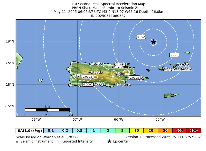 Spectral Acceleration |
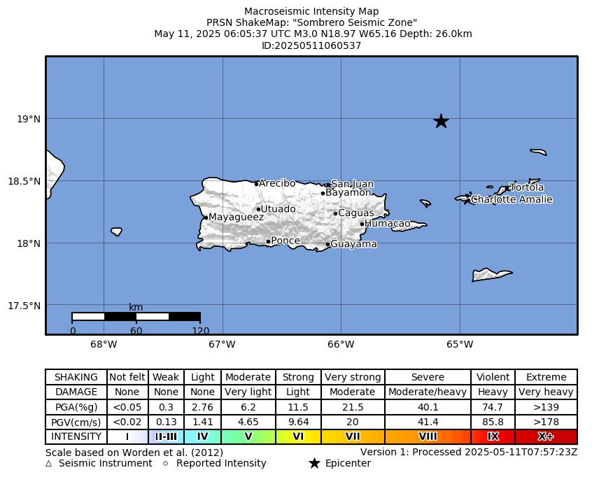 Intensity Map |
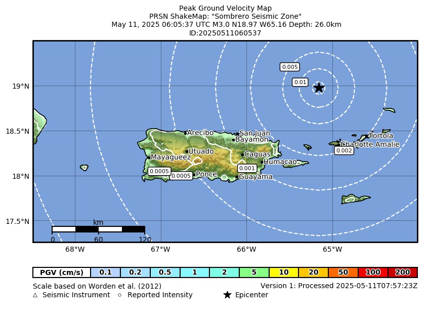 Peak Ground Velocity |
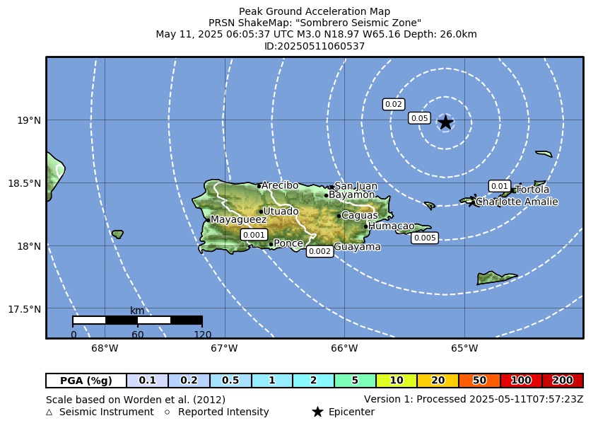 Peak Ground Acceleration |
 DYFI Map |
Google Map for this Event |