
This information is Issued for Puerto Rico and the Virgin Islands.For more information visit your corresponding Seismological Institution or theTsunami Warning Centers
| Event Details | |
|---|---|
| Estimated Maximum Intensity: | I |
| Date: |
September 25, 2025 03:51:39 UTC September 24, 2025 23:51:39 Hora Local |
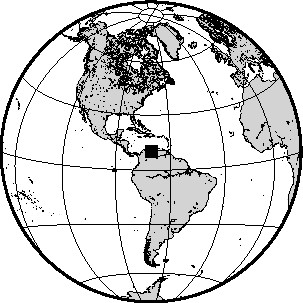
| Region: | VENEZUELA |
| Distances: |
897.53 Km South of Barahona,DR 942.42 Km South of Sto. Domingo,DR 990.03 Km South-Southeast of Mayagüez,PR |
| Magnitude: | 6.3 Mww |
| Location: | Latitude: 9.952 Longitude: -70.689 |
| Depth: | 10.0 Km |
| Tsunami Warning Level: | No Warning, Advisory or Watch is in effect for Puerto Rico and the Virgin Islands |
| Issued Date & Time | 2025-09-25 00:04:08 |
| ID: | 20250925035139 |
Epicentral Map
| BULLETIN 1 Seismic Event/Tsunami |
|
|---|---|
| DATE: | September 24, 2025 |
| LOCAL TIME: | 23:51:39 |
| LATITUDE: | 9.952 N |
| LONGITUDE: | 70.689 W |
| LOCATION: |
897.5 Km South of Barahona,DR
990 Km South-Southeast of Mayagüez,PR |
| DEPTH: | 10.0 Km |
| MAGNITUDE: | 6.3 Mww |
| ESTIMATED MAXIMUM INTENSITY: | I |
| TSUNAMI ALERT LEVEL: | No Warning, Advisory or Watch is in effect for Puerto Rico and the Virgin Islands |
| DATE & ISSUED TIME | 2025-09-25 00:04:17 |
| Based on magnitude, location and historic records the earthquake was not sufficient to generate a destructive tsunami to Puerto Rico and Virgin Islands. | |
|
|
Technical Information
There is no technical information available for this event.