
This information is Issued for Puerto Rico and the Virgin Islands.For more information visit your corresponding Seismological Institution or theTsunami Warning Centers
| Event Details | |
|---|---|
| Estimated Maximum Intensity: | II in Guánica, PR |
| Date: |
April 23, 2022 17:44:56 UTC April 23, 2022 13:44:56 Hora Local |
| Region: | South Region of Puerto Rico |
| Distances: |
9.84 Km Southeast of Guánica,PR 13.99 Km South-Southeast of Guayanilla,PR 28.5 Km West-Southeast of Ponce,PR |
| Magnitude: | 3.46 Md |
| Location: | Latitude: 17.9388 Longitude: -66.8393 |
| Depth: | 10 Km |
| Tsunami Warning Level: | No Warning, Advisory or Watch is in effect for Puerto Rico and the Virgin Islands |
| Issued Date & Time | 2022-04-23 14:07:14 |
| ID: | 20220423174457 |
Epicentral Map
| BULLETIN 2 Seismic Event/Tsunami |
|
|---|---|
| DATE: | April 23, 2022 |
| LOCAL TIME: | 13:44:56 |
| LATITUDE: | 17.9388 N |
| LONGITUDE: | 66.8393 W |
| LOCATION: |
9.8 Km Southeast of Guánica,PR
28.5 Km West-Southeast of Ponce,PR |
| DEPTH: | 10 Km |
| MAGNITUDE: | 3.46 Md |
| ESTIMATED MAXIMUM INTENSITY: | II in Guánica, PR |
| TSUNAMI ALERT LEVEL: | No Warning, Advisory or Watch is in effect for Puerto Rico and the Virgin Islands |
| DATE & ISSUED TIME | 2022-04-23 14:07:20 |
|
The Puerto Rico Seismic Network (PRSN) received information that this
minor earthquake was reported as
felt in Guánica with a maximum
intensity of II (Modified Mercalli Scale, MM).
At the moment of generating this bulletin no damages has been reported, but given the size and location this can not be ruled out Based on magnitude, location and historic records the earthquake was not sufficient to generate a destructive tsunami to Puerto Rico and Virgin Islands. |
|

|
|
Technical Information
YEAR MO DA  --ORIGIN--  --LAT N-  --LON W--  DEPTH   RMS   ERH   ERZ  XMAG  FMAG  PMAG  INT
2022-04-23  1744 56.61  17 56.33   66 50.36  10.88  0.23  0.51  0.58        3.46  3.46D II
                                                                                         SOURCE
NSTA NPHS  DMIN MODEL GAP ITR NFM NWR NWS NVR REMRKS-AVH  N.XMG-XMMAD-T   N.FMG-FMMAD-T  L F X
  44   44   5.8  PR1  180  14  22  36  18  44     Q  PPP   0.00  0.00     15.00  0.24 D

XMAG2-N.XMG2-XMMAD-T-S  FMAG2-N.FMG2-FMMAD-T-S  PREF.MAG-N.PMAG-PRMAD-T
                         3.46  15.00  0.24 Z        3.46  15.00  0.24 D

REGION= Southern Puerto Rico

STA NET COM CR DIST AZM  AN P/S WT   SEC (TOBS -TCAL -DLY  =RES)  WT   SR  INFO  CAL DUR-W-FMAG-T -AMP-U-PER-W-XMAG-T
GBPR PR HHZ  A  5.8 314 146 EP+ 1  59.07  2.46  2.26 0.00  0.20  1.04     0.095 0.58  77   3.13 Z
GBPR PR HH1  A  5.8 314 146 ES  1  61.04  4.43  4.02 0.00  0.41  1.04S    0.267
PR05 GS HHZ  A 12.1 350 121 EP+ 1  59.71  3.10  2.97 0.00  0.13  1.04     0.047 0.55  48   2.76 Z
PR05 GS HH2  A 12.1 350 121 ES  1  62.38  5.77  5.29 0.00  0.48  0.98S    0.178
PR03 GS HHZ  A 17.6 324 109 IPU    60.25  3.64  3.72 0.00 -0.08  2.07     0.132 0.55  59   2.98 Z
PR03 GS HH1  A 17.6 324 109 ES  1  63.29  6.68  6.62 0.00  0.06  1.04S    0.117
MLPR PR HHZ  A 22.0 279 103 EP+ 1  60.89  4.28  4.37 0.00 -0.09  1.04     0.081 0.55  95   3.44 Z
MLPR PR HH1  A 22.0 279 103 ES  1  64.21  7.60  7.78 0.00 -0.18  1.04S    0.120
PR01 GS HHZ  A 26.4 294 100 EP+ 1  61.52  4.91  5.04 0.00 -0.13  1.04     0.054
PR01 GS HH1  A 26.4 294 100 ES  1  65.27  8.66  8.97 0.00 -0.31  1.04S    0.086
OBIP PR BHZ  A 27.3  64  99 IPD    61.64  5.03  5.17 0.00 -0.14  2.07     0.203 0.87  87   3.20 Z
OBIP PR BHE  A 27.3  64  99 ES  1  65.66  9.05  9.20 0.00 -0.15  1.04S    0.110
CRPR PR HHZ  A 29.6 285  98 IPU    61.99  5.38  5.52 0.00 -0.14  2.07     0.285 0.55  71   3.22 Z
CRPR PR HH2  A 29.6 285  98 ES  1  66.08  9.47  9.83 0.00 -0.36  1.04S    0.104
CELP PR HHZ  A 31.4  61  97 IPD    62.26  5.65  5.80 0.00 -0.15  2.07     0.188 0.55  60   3.08 Z
CELP PR HH1  A 31.4  61  97 ES  1  66.68 10.07 10.32 0.00 -0.25  1.04S    0.105
ICMP PR HHZ  A 33.6  99  97 EP+ 1  62.77  6.16  6.14 0.00  0.02  1.04     0.122
ICMP PR HH2  A 33.6  99  97 ES  1  68.00 11.39 10.93 0.00  0.46  1.03S    0.202
UUPR PR HHZ  A 37.0  19  96 EP+ 1  63.35  6.74  6.65 0.00  0.09  1.04     0.035
UUPR PR HH1  A 37.0  19  96 ES  1  68.03 11.42 11.84 0.00 -0.42  1.04S    0.162
PRSN PR HHZ  A 44.7 314  94 EP+ 1  64.39  7.78  7.83 0.00 -0.05  1.04     0.038
PRSN PR HH2  A 44.7 314  94 ES  1  70.99 14.38 13.94 0.00  0.44  1.04S    0.096
AOPR PR HHZ  A 46.0  11  94 EP+ 1  64.59  7.98  8.04 0.00 -0.06  1.04     0.036 0.55  85   3.46 Z
AOPR PR HH2  A 46.0  11  94 ES  1  70.69 14.08 14.31 0.00 -0.23  1.04S    0.168
AGPR PR HHZ  A 65.2 334  66 IPU    67.62 11.01 10.81 0.00  0.20  1.79     0.235 0.55  89   3.52 Z
AGPR PR HH1  A 65.2 334  66 ES  1  76.08 19.47 19.24 0.00  0.23  0.89S    0.167
ECPR PR HHZ  A 65.7  50  66 EP+ 1  67.45 10.84 10.88 0.00 -0.04  0.88     0.049
ECPR PR HH1  A 65.7  50  66 ES  1  75.74 19.13 19.37 0.00 -0.24  0.88S    0.112
EMPR PR HHZ  A 68.0  28  66 EP+ 1  68.27 11.66 11.20 0.00  0.46  0.83     0.041 0.55  86   3.49 Z
EMPR PR HH1  A 68.0  28  66 ES  1  76.79 20.18 19.94 0.00  0.24  0.83S    0.122
SJG  IU BHZ  A 75.5  75  66 EP+ 1  69.01 12.40 12.26 0.00  0.14  0.62     0.033
SJG  IU BH2  A 75.5  75  66 ES  1  78.57 21.96 21.82 0.00  0.14  0.62S    0.057
IGPR PR HHZ  A 77.7  87  55 EP- 1  69.55 12.94 12.54 0.00  0.40  0.55     0.040 0.55  82   3.46 Z
IGPR PR HH1  A 77.7  87  55 ES  1  79.40 22.79 22.32 0.00  0.47  0.55S    0.073
IDE  PR EHZ  A 82.7 307  55 EP+ 1  70.43 13.82 13.19 0.00  0.63* 0.01     0.000 0.58  88   3.51 Z
IDE  PR EHN  A 82.7 307  55 ES  1  80.69 24.08 23.48 0.00  0.60* 0.04S    0.000
GCPR PR HHZ  A 89.9  62  55 IPD    70.92 14.31 14.09 0.00  0.22  0.40     0.015
GCPR PR HH2  A 89.9  62  55 ES  1  81.67 25.06 25.08 0.00 -0.02  0.20S    0.007
HUMP PR HHZ  A107.3  77  55 EP+ 2  73.48 16.87 16.29 0.00  0.58* 0.00     0.000 0.55 102   3.69 Z
HUMP PR HH2  A107.3  77  55 ES  2  86.16 29.55 29.00 0.00  0.55* 0.00S    0.000
MTP  PR HHZ  A137.4  82  55 EP+ 2  78.26 21.65 20.10 0.00  1.55* 0.00     0.000 0.55 108   3.78 Z
MTP  PR HH1  A137.4  82  55 ES  2  93.57 36.96 35.78 0.00  1.18* 0.00S    0.000
CUPR PR HHZ  A169.7  75  55 EP- 2  83.06 26.45 24.20 0.00  2.25* 0.00     0.000 0.55 107   3.80 Z
CUPR PR HH2  A169.7  75  55 ES  2 102.84 46.23 43.08 0.00  3.15* 0.00S    0.000
Event Maps
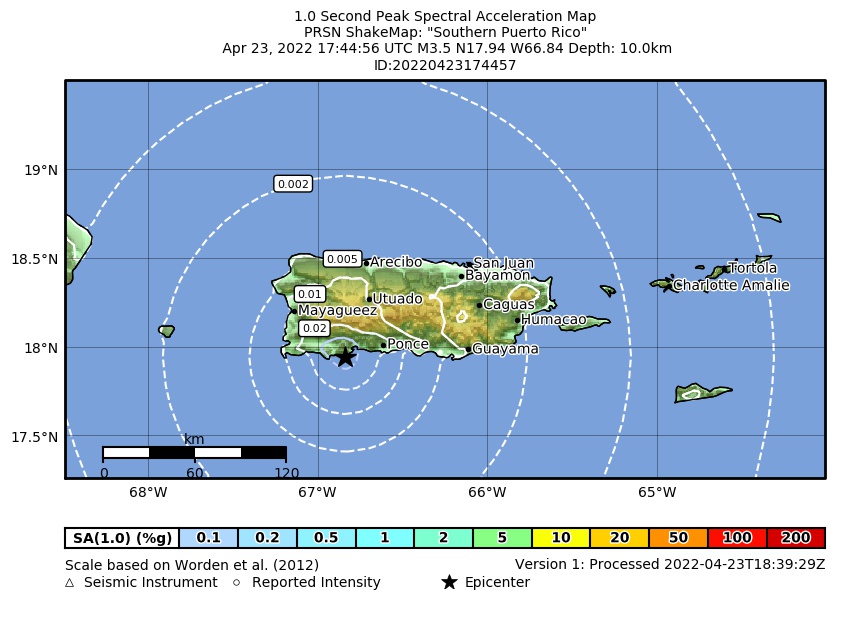 Spectral Acceleration |
 Intensity Map |
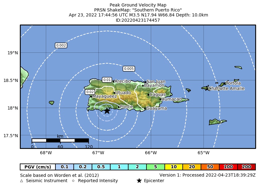 Peak Ground Velocity |
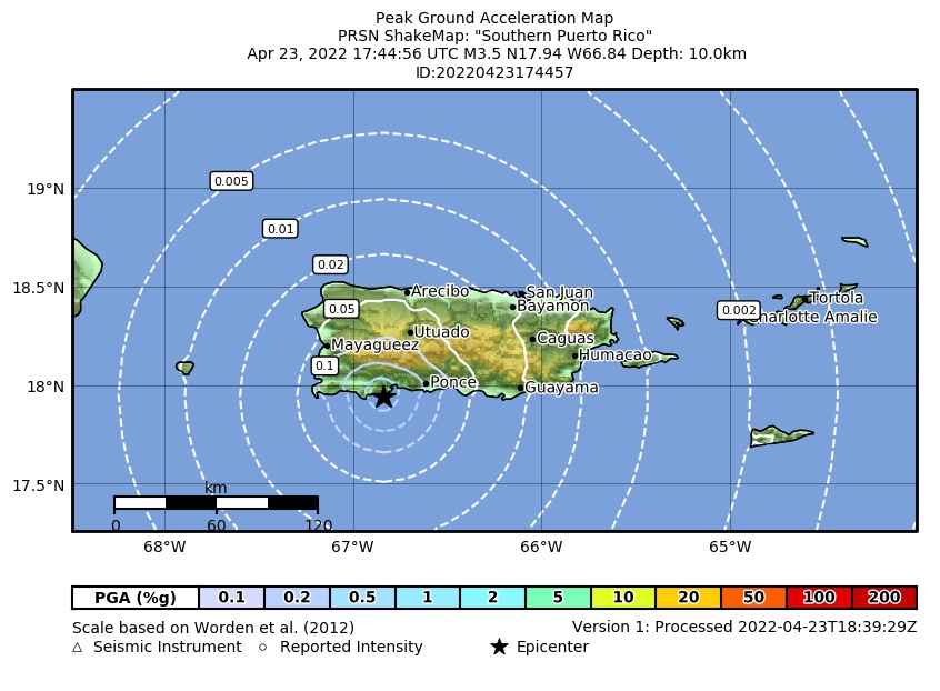 Peak Ground Acceleration |
 DYFI Map |
Google Map for this Event |