
This information is Issued for Puerto Rico and the Virgin Islands.For more information visit your corresponding Seismological Institution or theTsunami Warning Centers
| Event Details | |
|---|---|
| Estimated Maximum Intensity: | IV in Aguada, PR |
| Date: |
October 23, 2022 05:05:39 UTC October 23, 2022 01:05:39 Hora Local |
| Region: | Eastern Dominican Republic |
| Distances: |
17.55 Km West of Punta Cana,DR 20.12 Km North-Northwest of Higüey,DR 189.13 Km West-Northwest of Mayagüez,PR |
| Magnitude: | 4.66 Md |
| Location: | Latitude: 18.7546 Longitude: -68.7326 |
| Depth: | 119 Km |
| Tsunami Warning Level: | No Warning, Advisory or Watch is in effect for Puerto Rico and the Virgin Islands |
| Issued Date & Time | 2022-10-23 02:42:07 |
| ID: | 20221023050541 |
Epicentral Map
| BULLETIN 2 Seismic Event/Tsunami |
|
|---|---|
| DATE: | October 23, 2022 |
| LOCAL TIME: | 01:05:39 |
| LATITUDE: | 18.7546 N |
| LONGITUDE: | 68.7326 W |
| LOCATION: |
17.6 Km West of Punta Cana,DR
189.1 Km West-Northwest of Mayagüez,PR |
| DEPTH: | 119 Km |
| MAGNITUDE: | 4.66 Md |
| ESTIMATED MAXIMUM INTENSITY: | IV in Aguada, PR |
| TSUNAMI ALERT LEVEL: | No Warning, Advisory or Watch is in effect for Puerto Rico and the Virgin Islands |
| DATE & ISSUED TIME | 2022-10-23 02:42:13 |
|
The Puerto Rico Seismic Network (PRSN) received information that this
light earthquake was reported as
felt in the Western region of Puerto Rico with a maximum
intensity of IV (Modified Mercalli Scale, MM).
At the moment of generating this bulletin no damages has been reported, but given the size and location this can not be ruled out Based on magnitude, location and historic records the earthquake was not sufficient to generate a destructive tsunami to Puerto Rico and Virgin Islands. |
|

|
|
Technical Information
YEAR MO DA  --ORIGIN--  --LAT N-  --LON W--  DEPTH   RMS   ERH   ERZ  XMAG  FMAG  PMAG  INT
2022-10-23  0505 39.61  18 45.28   68 43.96 119.83  0.65  5.85  2.26        4.66  4.66D IV
                                                                                         SOURCE
NSTA NPHS  DMIN MODEL GAP ITR NFM NWR NWS NVR REMRKS-AVH  N.XMG-XMMAD-T   N.FMG-FMMAD-T  L F X
  61   61  18.1  PR1  179  21  34  61  27  61     Q# PPW   0.00  0.00     29.00  0.08 D

XMAG2-N.XMG2-XMMAD-T-S  FMAG2-N.FMG2-FMMAD-T-S  PREF.MAG-N.PMAG-PRMAD-T
                         4.66  29.00  0.08 Z        4.66  29.00  0.08 D

REGION= Eastern Dominican Republic

NEW COMMENT: 4.4 Mb (NEIC), 4.8 Ml (PTWC), 5.1 Ml (NEB)

STA NET COM CR DIST AZM  AN P/S WT   SEC (TOBS -TCAL -DLY  =RES)  WT   SR  INFO  CAL DUR-W-FMAG-T -AMP-U-PER-W-XMAG-T
HIDR DR BHZ  A 18.1 174 171 IPD    55.89 16.28 16.14 0.00  0.14  1.55     0.215
HIDR DR BHN  A 18.1 174 171 ES  1  68.02 28.41 28.73 0.00 -0.32  0.77S    0.222
PCDR PR BHZ  A 45.6 125 158 IPD    56.56 16.95 17.06 0.00 -0.11  1.55     0.144 0.55 233   4.57 Z
PCDR PR BHN  A 45.6 125 158 ES  1  70.96 31.35 30.37 0.00  0.98* 0.77S    0.175
SDD  DR BHZ  A129.1 256 131 IPU    62.30 22.69 23.32 0.00 -0.63* 1.55     0.345 0.73 200   4.40 Z
IDE  PR EHZ  A139.8 106 128 IPD    63.49 23.88 24.35 0.00 -0.47  1.55     0.046 0.58 204   4.53 Z
AGPR PR HHZ  A174.1 100 122 IPD    68.39 28.78 27.88 0.00  0.90* 1.55     0.074 0.55 223   4.67 Z
AGPR PR HH2  A174.1 100 122 ES  1  89.45 49.84 49.63 0.00  0.21  0.77S    0.077
PRSN PR HHZ  A178.0 109 122 EP- 2  69.01 29.40 28.30 0.00  1.10* 0.31     0.001 0.55 159   4.36 Z
PRSN PR HH1  A178.0 109 122 ES  1  90.38 50.77 50.37 0.00  0.40  0.77S    0.046
CRPR PR HHZ  A190.5 115 120 IPD    68.38 28.77 29.66 0.00 -0.89* 1.55     0.073 0.55 224   4.69 Z
CRPR PR HH2  A190.5 115 120 ES  2  91.95 52.34 52.79 0.00 -0.45  0.31S    0.012
PR01 GS HHZ  A193.1 114 119 IPD    68.82 29.21 29.95 0.00 -0.74* 1.55     0.064 0.55 204   4.61 Z
PR01 GS HH2  A193.1 114 119 ES  1  92.49 52.88 53.31 0.00 -0.43  0.77S    0.068
MLPR PR HHZ  A198.5 115 119 IPU    69.27 29.66 30.54 0.00 -0.88* 1.55     0.078 0.55 226   4.71 Z
MLPR PR HH1  A198.5 115 119 ES  1  93.58 53.97 54.36 0.00 -0.39  0.77S    0.077
PR03 GS HHZ  A204.4 111 118 IPD    70.84 31.23 31.19 0.00  0.04  1.55     0.046 0.55 185   4.53 Z
PR03 GS HH1  A204.4 111 118 ES  1  95.01 55.40 55.52 0.00 -0.12  0.77S    0.049
PR05 GS HHZ  A212.8 111 117 IPD    71.81 32.20 32.14 0.00  0.06  1.55     0.049 0.55 208   4.65 Z
PR05 GS HH2  A212.8 111 117 ES  2  97.84 58.23 57.21 0.00  1.02* 0.31S    0.007
AOPR PR HHZ  A213.7 101 117 IPU    71.93 32.32 32.24 0.00  0.08  1.55     0.055 0.55 200   4.61 Z
AOPR PR HH1  A213.7 101 117 ES  1  97.35 57.74 57.39 0.00  0.35  0.77S    0.050
GBPR PR HHZ  A214.1 113 117 IPD    71.17 31.56 32.28 0.00 -0.72* 1.55     0.066 0.58 216   4.66 Z
GBPR PR HH2  A214.1 113 117 ES  1  97.55 57.94 57.46 0.00  0.48  0.77S    0.063
UUPR PR HHZ  A219.7 104 116 IPD    73.00 33.39 32.91 0.00  0.48  1.55     0.038 0.55 175   4.50 Z
UUPR PR HH2  A219.7 104 116 ES  1  97.69 58.08 58.58 0.00 -0.50  0.77S    0.036
PR02 GS HHZ  A223.1 111 116 IPD    73.26 33.65 33.30 0.00  0.35  1.55     0.053 0.55 203   4.64 Z
PR02 GS HH2  A223.1 111 116 ES  1  99.19 59.58 59.27 0.00  0.31  0.77S    0.050
PR06 GS HHZ  A225.9 109 115 EP+ 2  74.46 34.85 33.61 0.00  1.24* 0.31     0.001 0.55 138   4.29 Z
PR06 GS HH1  A225.9 109 115 ES  1  99.75 60.14 59.83 0.00  0.31  0.77S    0.040
EMPR PR HHZ  A234.6  97 115 IPD    74.07 34.46 34.61 0.00 -0.15  1.55     0.096 0.55 208   4.67 Z
EMPR PR HH2  A234.6  97 115 ES  1 100.98 61.37 61.61 0.00 -0.24  0.77S    0.075
OBIP PR BHZ  A238.1 108 114 IPU    74.50 34.89 35.02 0.00 -0.13  1.55     0.042 0.87 219   4.52 Z
OBIP PR BHE  A238.1 108 114 ES  1 102.23 62.62 62.34 0.00  0.28  0.77S    0.036
CELP PR HHZ  A239.7 107 114 IPU    74.41 34.80 35.20 0.00 -0.40  1.55     0.039 0.55 205   4.66 Z
CELP PR HH1  A239.7 107 114 ES  1 102.34 62.73 62.66 0.00  0.07  0.77S    0.033
ICMP PR HHZ  A252.3 112 113 IPD    75.29 35.68 36.65 0.00 -0.97* 1.55     0.075 0.55 206   4.68 Z
ICMP PR HH2  A252.3 112 113 ES  1 104.04 64.43 65.24 0.00 -0.81* 0.77S    0.060
ECPR PR HHZ  A254.9 100 113 IPU    76.25 36.64 36.95 0.00 -0.31  1.55     0.062 0.55 210   4.70 Z
ECPR PR HH1  A254.9 100 113 ES  2 104.50 64.89 65.77 0.00 -0.88* 0.31S    0.007
SDDR CU BHZ  A270.5 276 111 IPU    79.56 39.95 38.78 0.00  1.17* 1.55     0.398 0.00 210   3.86 Z
SJG  IU BHZ  A282.0 104 111 EP- 2  81.07 41.46 40.14 0.00  1.32* 0.31     0.001 0.73 211   4.61 Z
SJG  IU BH2  A282.0 104 111 ES  2 110.15 70.54 71.45 0.00 -0.91* 0.31S    0.004
GCPR PR HHZ  A284.1  99 110 IPD    79.58 39.97 40.38 0.00 -0.41  1.55     0.072 0.55 208   4.73 Z
GCPR PR HH1  A284.1  99 110 ES  1 110.90 71.29 71.88 0.00 -0.59* 0.77S    0.047
IGPR PR HHZ  A291.0 107 110 IPD    80.06 40.45 41.20 0.00 -0.75* 1.55     0.053 0.55 211   4.75 Z
IGPR PR HH1  A291.0 107 110 ES  2 113.13 73.52 73.34 0.00  0.18  0.31S    0.005
HUMP PR HHZ  A312.2 102 109 IPU    83.30 43.69 43.73 0.00 -0.04  1.55     0.056 0.55 203   4.74 Z
HUMP PR HH2  A312.2 102 109 ES  2 116.56 76.95 77.84 0.00 -0.89* 0.31S    0.004
MTP  PR HHZ  A343.9 101 107 EP- 2  87.93 48.32 47.54 0.00  0.78* 0.31     0.002 0.55 204   4.77 Z
MTP  PR HH2  A343.9 101 107 ES  2 123.05 83.44 84.62 0.00 -1.18* 0.31S    0.005
CUPR PR HHZ  A367.8  97 106 IPU    88.81 49.20 50.44 0.00 -1.24* 1.55     0.099 0.55 199   4.79 Z
STVI PR HHZ  A401.4  95 104 IPU    94.04 54.43 54.53 0.00 -0.10  1.55     0.127 0.55 186   4.78 Z
STVI PR HH1  A401.4  95 104 ES  1 134.94 95.33 97.06 0.00 -1.73* 0.77S    0.071
CDVI PR HHZ  A434.3 104 103 EP- 1  97.33 57.72 58.58 0.00 -0.86* 0.77     0.018 0.55 198   4.90 Z
CDVI PR HH1  A434.3 104 103 ES  2 143.89104.28104.27 0.00  0.01  0.31S    0.005
SABA NA BHZ  A595.0 101  99 EP+ 1 118.76 79.15 78.49 0.00  0.66* 0.77     0.024
SABA NA BHN  A595.0 101  99 ES  1 177.35137.74139.71 0.00 -1.97* 0.77S    0.035
SMRT NA BHZ  A603.8  96  99 EP- 1 118.36 78.75 79.58 0.00 -0.83* 0.77     0.032
ABD  WI BHZ  A811.1 107  97 EP+ 1 144.36104.75105.55 0.00 -0.80* 0.77     0.035
DSD  WI BHZ  A860.0 107  96 EP- 1 150.22110.61111.69 0.00 -1.08* 0.77     0.036
Event Maps
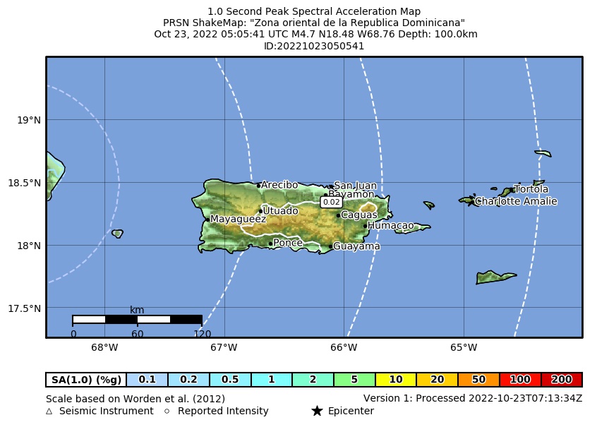 Spectral Acceleration |
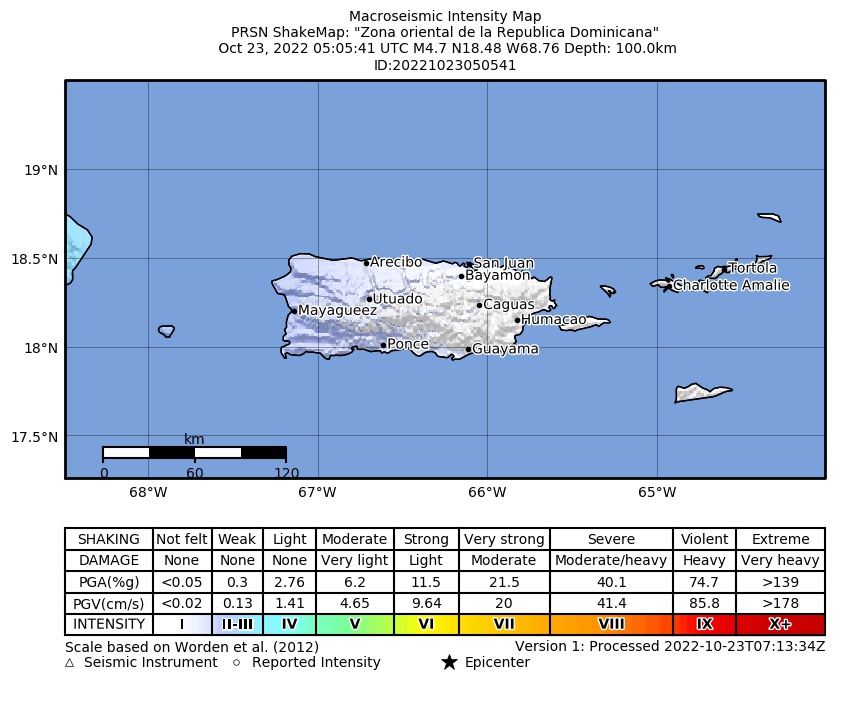 Intensity Map |
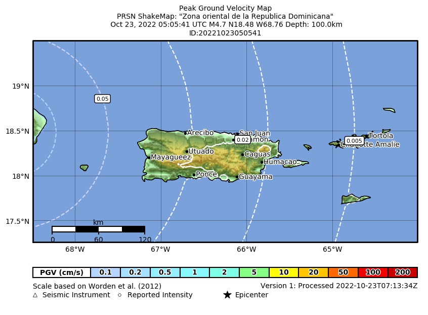 Peak Ground Velocity |
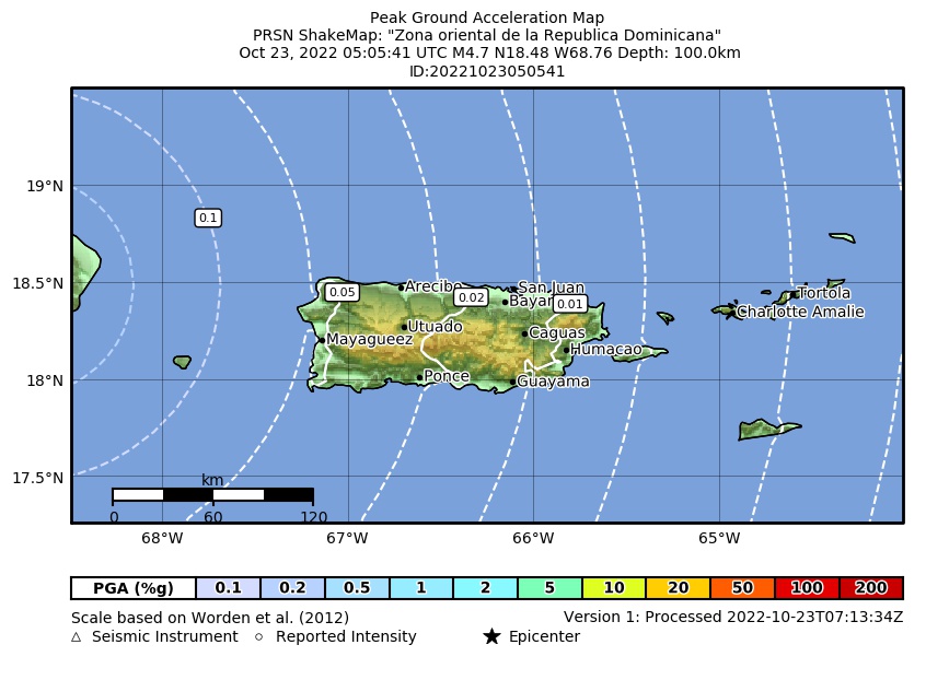 Peak Ground Acceleration |
 DYFI Map |
Google Map for this Event |